Alaska leads the way for ADS-B
It's the toughest proving ground in the world. And Alaska has proven that ADS-B (automatic dependent surveillance-broadcast) is the affordable technology of the future, making general aviation safer and the FAA more efficient.
"So much technology works its way up here from the Lower 48," AOPA President Phil Boyer said this weekend at the Alaska State Aviation Trade Show and Conference in Anchorage. "You are to be congratulated for being the first to show the world that ADS-B is the ground-breaking technology for aviation of the twenty-first century."
Alaska uncovers the glitches
It's called Capstone in Alaska, where ADS-B has progressed from an idea, to a proof-of-concept, to a full "beta version" that is already saving lives.
But like any development project, there have been some setbacks, including most recently when the ADS-B targets were taken off controllers' scopes because the procedures for using that information haven't been fully defined.
"The Alaskan proving ground has helped uncover the glitches — both technical and regulatory — and now we're getting close to version 1.0 to deploy throughout the nation," Boyer said.
ADS-B for the world
In fact, deployed around the world. Delegations from China, Ethiopia, and South Africa will be visiting AOPA headquarters in the near future to see ADS-B in action. "If you were building a system from scratch, this is what you would do today. It can be deployed in the most remote areas; it's affordable for third-world countries," Boyer said.
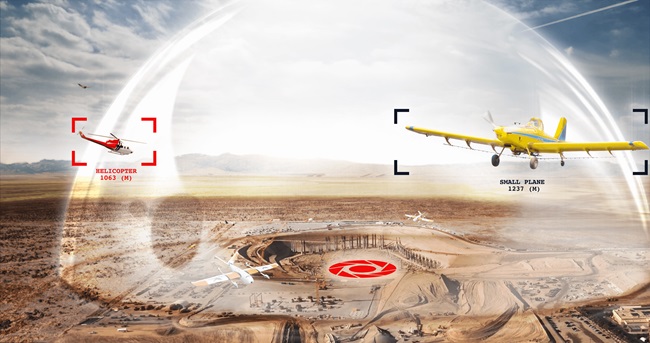
But even in Alaska, many pilots still have a hard time understanding exactly how the system can replace radar and send weather data to the cockpit, and provide collision avoidance.
 Illustration by John Macneil |
Like an airborne Internet
"With GPS, a pilot knows his exact position in space," Boyer explained. "Now what if you could tell everybody else where you are, by using a wireless Internet connection? And what if you could send more data through that connection, just like the Internet works in both directions?"
That's ADS-B.
A GPS receiver sends the aircraft's position to the "Internet connection" — called a universal access transceiver (UAT). A simple two-way radio broadcasts the plane's position and altitude information every second.
Other aircraft can listen in on that transmission and plot every transmitting aircraft's position on a display screen.
Better than radar?
Air traffic control is on that party line as well and can receive the automatic position reports through simple, remote ground receivers. Those receivers can be installed in places where radar would be too costly or impractical, meaning ATC surveillance can be extended to places where it's never been available before.
ADS-B is not subject to radar's "line of sight" limits, and it updates more frequently. Because radar sweeps in a circle, it only "knows" where an aircraft is for certain once every six seconds (12 seconds for en route radar), while ADS-B updates every second.
A better ELT
But more important for the average GA pilot, ADS-B makes a much better ELT — emergency locator transmitter. Whether or not you're talking to ATC, the ATC computers are recording the position of your aircraft — every second. If search and rescue needs to find you, they'll know the exact track of your flight, probably up to the last few seconds. That data-recording feature has already saved the life of at least one Alaskan pilot.
Traffic and weather together
For GA, the greatest benefit of ADS-B lies in its two-way transmission capability. While an aircraft is transmitting its position to other aircraft and the ground, the ground can be transmitting weather graphics and text back to the aircraft. (It's called FIS-B, flight information service-broadcast.)
AOPA has insisted that this basic weather information be available for free. That means pilots in any ADS-B equipped aircraft anywhere in the country will have the same weather resources in the cockpit that they now have on the ground for flight planning — NEXRAD weather radar images no more than six minutes old, current area and terminal weather forecasts (TAFs), and current weather reports (METARs).
And not just weather, but traffic information as well, including the position of other non-ADS-B equipped aircraft. (Yet another acronym — TIS-B, for traffic information service-broadcast.) That's because current tracon radar systems can transmit the position of every aircraft they're "painting" up the two-way datalink.
Free FIS-B and TIS-B are already available in Alaska and some of the East Coast. The FAA has announced that it will be installing ADS-B ground stations throughout the rest of the nation, making FIS-B and TIS-B available elsewhere. The agency says the full transition to ADS-B will likely take 20 years.
Traffic and weather together, for free. Not a bad deal at all. And we can thank our fellow pilots in Alaska for proving that it will work.
For more information, see " President's Position: ADS-B" and AOPA's issue brief.
May 10, 2006