Custom content for the Nov. 18, 2011, issue of 'AOPA ePilot' newsletter
| The following stories from the Nov. 18, 2011, edition of AOPA ePilot were provided to AOPA members who expressed an interest in the particular subject areas. Any AOPA member can receive information tailored to their areas of interest by updating their preferences online |
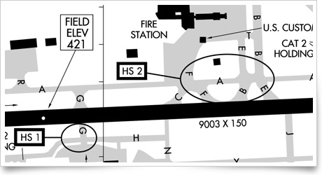
training tipsKnow the ‘hot spots’ From making sure to avoid a prohibited area close to the route, to safely overflying rapidly rising terrain starting about 100 miles along the course (vividly depicted graphically by the profile view in the AOPA Internet Flight Planner), to noting airports that could serve as emergency fields, there were many details to consider. The destination airport’s location within Class C airspace prompted the pilot to review communications procedures and equipment requirements. To be even better prepared, the pilot went online and listened to some air traffic control broadcasts to get a feel for local arrival and departure operations. Studying the diagram of Syracuse’s two-runway airport with its network of parallel and intersecting taxiways, the pilot did not know what to make of two areas designated on the diagram as HS 1 and HS 2. What did those symbols mean? Checking sources of airport information, the pilot found out that the symbols refer to hot spots on the airport—as explained in the FAA’s airport/facility directory, which contains a section with legend, supplemental, and airport hot spot information. Hot spots are also shown on airport listings in AOPA Airports. A hot spot is “a runway safety related problem area on an airport that presents increased risk during surface operations,” explains the airport/facility directory. “Typically it is a complex or confusing taxiway/taxiway or taxiway/runway intersection. The area of increased risk has either a history of or potential for runway incursions or surface incidents.” Hot spots “are depicted on airport diagrams as open circles or polygons designated as ‘HS 1,’ ‘HS 2,’ etc.” This report of a collision of two taxiing aircraft in Syracuse on March 31, 1989, is a good example of the kinds of problems known to occur in hot spots. Asking for progressive taxi instructions can help you avoid trouble at an unfamiliar towered airport, or under conditions of limited visibility. Staying alert and taxiing at a safe speed should offer safe passage until you are ready to take off again on your way home. training productsLittle Pilot Logbook helps to capture flying memoriesIf you have a young aviator in the family or know of a youngster who’s interested in aviation, how do you help to nurture that enthusiasm? AOPA member Asavri Gupte designed a flying keepsake journal specifically for children. The Little Pilot Logbook is an 8.75-by-5.75-inch spiral-bound book with flight log pages, but it also features places to record memorable stories and display photos, including on the front cover. The Little Pilot Logbook sells for $24.95. For product and purchasing information, see the website.
Note: Products listed have not been evaluated by ePilot editors unless otherwise noted. AOPA assumes no responsibility for products or services listed or for claims or actions by manufacturers or vendors. final exam
Question: What is a TRSA?
Answer: TRSA stands for terminal radar service area and is depicted on VFR charts with a solid black line (see Wilmington International Airport and Harrisburg International Airport for examples) with altitudes for different segments. The airspace works similarly to Class C airspace; however, from a regulatory standpoint it is not considered controlled airspace because it was not subject to the rulemaking process. Because of that, TRSAs do not really fit into any of the U.S. airspace classes. That is also why you will not find any operating rules for them in Part 91. You will likely find a TRSA around a Class D airport that has relatively high traffic yet does not qualify for Class C or Class B airspace. TRSA service provides radar sequencing and separation between all participating VFR aircraft and all IFR aircraft operating within the airspace defined by the TRSA. Although participation is voluntary, VFR pilots are encouraged to use the services provided by the TRSA. For more, check out the Air Safety Institute’s Know Before You Go: Navigating Today’s Airspace online course.
Got a question for our technical services staff? E-mail [email protected] or call the Pilot Information Center, 800/872-2672. Don’t forget the online archive of “Final Exam” questions and answers, searchable by keyword or topic. |