You’ve asked for it, and now it’s here. AOPA now offers members a free, full-function airport information and flight-planning iPhone application, which also works on the iPad.
FlyQ features airport information, weather briefings and graphics, a robust flight-planning engine, and the ability to file flight plans. The app was designed with readability, flexibility, and speed as three key elements. 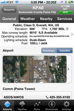
Main navigation of the application is done through five tabs at the bottom—Airports, Weather, Plans, Downloads, and Settings. The application first opens to the airport page—loading info for the airport nearest you thanks to the phone’s onboard GPS receiver. Data for other nearby airports is presented on the same page. Weather is quick and easy to assess, thanks to a color-coded bar right below the airport symbol, which looks just like you’d find it on the sectional. If it’s green, you can go VFR, yellow is for marginal VFR, and red means IFR. The symbol and weather bar sit left of primary information, including distance and direction from current location, the traffic pattern altitude, class of airspace, main frequency, and longest runway. From the airport page you can choose to search airports anywhere in the country, or look at recent selections.
Click on any airport and you’re rewarded with all the necessary airport information, including a satellite photo, nearby navaids, and detailed runway information. All of AOPA’s extensive airport information you can currently find in the printed airport directory or on AOPA Airports online is included here, including FBOs, restaurants, and more. Tabs at the top deep-dive into the weather, such as METARs and TAFs—raw or translated, thank you—maps, winds aloft, and a DTC DUAT briefing. The final tab, Nearby, links to other airports. The care that went into development is on display on any weather page with a simple click. Each report and map has a box that will extend it out and make it bigger, and thereby easier to read on a phone.
 The main Weather button on the bottom menu bar includes much of the same information, but is not necessarily location-based. Dozens of weather maps are in the gallery for easy viewing, including animated radar and other popular products.
The Plans tab is where the app really shines. The biggest downfall of most electronic flight bag (EFB) apps is their total lack of flight planning ability. Sure you can go direct, but there are many parts of the country where that simply isn’t possible. In those cases, you must manually key in a route waypoint by waypoint. The flight-planning engine in FlyQ is beyond anything else out there, thanks to a partnership with Seattle Avionics. You can plan direct, no wind, airways, and more. And since the user’s information lives in the cloud, an upcoming feature will allow you to plan with AOPA’s online flight planner, and it will sync to your phone or iPad.
Because of its simplicity, and use of many functions in the cloud, the app is fast to use, even over a wireless 3G network. Although only iOS is supported now, AOPA members have asked for Android applications, and the association is committed to supporting those members. That’s why they should expect full Android capabilities sometime this summer.
FlyQ is free and exclusively for AOPA members, and is available now in the Apple App Store. AOPA Airports for iPhone is now AOPA FlyQ and requires a new app download from the App Store. Learn more about the app online.