 With the release of its WAAS-equipped flight decks and stand-alone navigation units, Garmin introduced advisory vertical navigation capability for nearly all RNAV approaches, not just those that have published WAAS minimums. Even plain-vanilla GPS approaches could now be flown like an ILS approach—albeit one with the relatively high minimums that a lack of WAAS imposes. Given that nearly all airports have either an ILS, WAAS-GPS, or basic GPS approach, light-jet pilots flying behind a Garmin panel quickly become accustomed to having fully coupled vertical guidance on nearly all approaches.
What sometimes is not understood is that the ability to create the advisory glidepath (GP) during an approach is dependent upon good WAAS reception. Only vertical position information corrected by WAAS is accurate enough, and of sufficiently high integrity, to allow vertical navigation of any sort on an approach—even if only advisory.
Early this year, at a type club regional event held in Puerto Rico, two different pilots commented that they didn’t receive expected vertical guidance during the RNAV approach into San Juan’s main GA airport, Fernando Luis Ribas Dominicci Airport (TJIG) also called Isla Grande. The notes box at the top of the TJIG RNAV 9 approach plate unfortunately provides no clue that something might be amiss.
A pilot would need to look at an RNAV approach at San Juan’s larger airport (TJSJ) for a subtle clue that the expected “+V” (indicating presence of advisory GP) may not be available at TJIG. The TJSJ RNAV 10 note box includes the statement “WAAS VNAV NA.” This is printed on the TJSJ approach because, unlike the TJIG RNAV 9, this approach does feature a line of minimums which is associated with WAAS: LNAV/VNAV.
Not to be confused with LNAV+V, LNAV/VNAV minimums require either WAAS or a flight management system (FMS) capable of barometric approach vertical navigation (VNAV). Rather than comparing the aircraft’s GPS-derived and WAAS-enhanced vertical position to desired vertical position, “baro” VNAV compares the aircraft’s barometric altitude to a reference altitude for each given position on the approach.
On the TJSJ RNAV 10, baro VNAV is the only way to use the LNAV/VNAV minimums; the note makes clear that use of WAAS-dependent VNAV is not authorized for the approach.
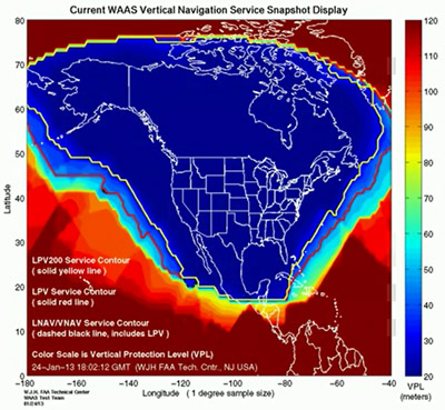
Garmin’s “+V” is WAAS dependent, and so is explicitly not authorized at TJIG. Why? Even though Puerto Rico hosts a wide area reference station (WRS) to upload corrected GPS position information, and lies well inside the reception “footprint” of WAAS satellites, the critical vertical protection limit (VPL) value over Puerto Rico is often far above the maximum acceptable.
VPL, a measurement of how far above or below the actual aircraft position the GPS receiver could think that it is—using the WAAS correction information available—is a primary determination of whether WAAS approaches are possible at a given moment.
For large parts of the day during the San Juan fly-in, the VPL across all of Puerto Rico was greater than 400 feet—more than double the allowable VPL for even the lowest minimum WAAS approach category of LNAV/VNAV.
Pilots will do well to remember that operations on the edges of the WAAS service areas can be very different from the day-to-day operations in the Lower 48, and should expect some differences in the way even non-WAAS GPS approaches are flown as a result.
Neil Singer is a Master CFI with more than 8,400 hours and 15 years of instructing.