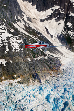
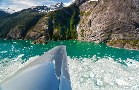
Jagged peaks—some of them more than a mile high—line both sides of Alaska’s Stikine River as we follow the winding waterway up a deep glacial valley. Torrents of opaque, robin’s-egg-blue meltwater mark our path through what looks like an impossibly vivid, three-dimensional video game. Shimmering fields of massive ice blocks on the Le Conte Glacier carve deep trenches along the rocky valley floor as the irresistible force bulls its way to the sea. On the valley’s nearly vertical rock walls, pine trees with branches stunted by hurricane-force winter winds defiantly cling to their footholds, and cascading waterfalls many hundreds of feet high pass by in a blur.
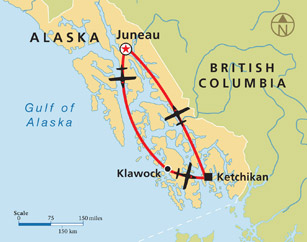
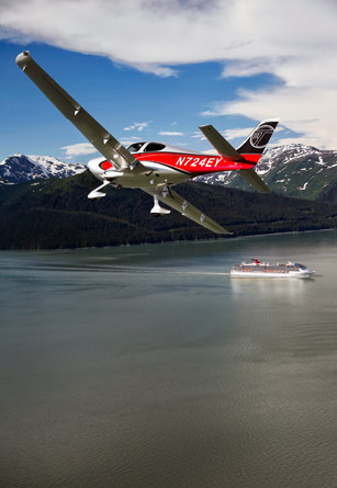
I’m flying with Jill “Ivy” McIver, Cirrus Aircraft sales director for the Pacific Northwest, and Chris Rose, AOPA photographer, in an urbane, technologically advanced Cirrus SR22 Generation 5 that seems like an out-of-place city slicker in this vast wilderness. But the turbocharged, 185-knot G5 is proving more than a match for the demanding trip. This morning, it carried us nonstop 620 nm from Seattle to Ketchikan, Alaska, covering the “inside passage” in four hours with the safety and situational awareness that come from synthetic vision, ADS-B weather and traffic, ice protection, and an airframe parachute. And on this second leg of the trip—a 60-minute jaunt to Juneau with a sightseeing detour over a formidable ring of glaciers—the airplane provides a remarkable, highly maneuverable perch from which to take in this string of natural wonders.
Our airplane is among a group of six Cirrus SR22s and SR20s that launched together from Boeing Field for a five-day tour of southeast Alaska organized by The Flight Academy, a Seattle firm that specializes in Cirrus training. Several instructors from The Flight Academy are taking part in the company’s tenth Alaska tour, and they are starting to hear questions that seldom arise in the flatter parts of the lower 48 states.
“Is there any way to turn off this lady’s voice?” Jay Klein of Amarillo, Texas, asks from another G5 on the air-to-air radio frequency, referring to the aural warnings in the Garmin Perspective avionics suite. “She just keeps saying the same things over and over again.” (Terrain ahead! Pull up! Terrain! ) McIver relays instructions on how to silence the constant warnings (“Go to the Terrain page and hit the ‘Inhibit’ soft key.”)
This panhandle portion of Alaska is a rain forest and the mountains are shrouded in low clouds more than 300 days a year. But on this June afternoon a week before the summer solstice, the sky is brilliantly clear and reveals details of the dramatic landscape with exceptional clarity. Our circular path through the mountains and over the glaciers leads us back to the coast, and when we get there we turn northwest again and follow the Stephens Passage, as well as the cruise ships plying it, to Juneau International Airport (PAJN). We have covered about 750 nm in five flight hours since leaving Seattle. But the flight conditions are too perfect, and too rare, to stay on the ground.
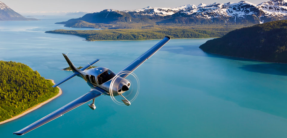
After refueling ($6.70 per gallon), the two G5s fly northwest together for a photography mission over Glacier Bay, a broad expanse of tranquil water just 40 nm away renowned for whales and abundant sea life. We take off together and cross the Lynn Canal and scenic Chilkat Range with its ragged, snow-capped 6,000-foot peaks, then descend over the bay.
Countless rivers, streams, and waterfalls flow into this wide expanse that mixes with the Pacific Ocean less than 30 nm to the west. The surrounding peaks are so tall, however; the distances are so vast; and the air is so clear that any sense of scale is elusive. To the west, ironically named Mount Fairweather rises 15,300 feet from its base at sea level. To the north, the glacier-topped St. Elias Mountains exceed 9,000 feet. And to the east, the cliffs of the Chilkat Range rise almost vertically from the bay’s pristine water. A pod of humpback whales feeds on candlefish or krill a mere 50 feet from the rocky shoreline.
It’s a few minutes after 9 p.m., and the sun is still well above the horizon at this latitude of 58 degrees. The nearly constant daylight, and the fact that our compass swings leisurely with errors of 30 degrees or more, adds to a vague but persistent feeling of disorientation. We fly parallel, and at eye level, to a series of towering palisades and then circle the mirror-smooth waters at the foot of the fragmented Casement Glacier.
This is the first day of my first-ever trip to Alaska, and I can’t imagine a more wondrous place to fly.
The fun part
This annual trip to southeast Alaska is the inspiration of Luke Lysen, founder of The Flight Academy, who spent six summers here during his late teens and twenties working on commercial fishing boats. The tall, easygoing, unflappable pilot/instructor/business owner thought he had left the place behind. But he was drawn back a decade ago when he and two brothers returned to the region for a flying/fishing trip. And it became obvious to Lysen that clients at his then-new aviation business would enjoy flying there in their own airplanes—and the experience would make them better, more confident pilots.


“I love Alaska’s natural beauty and its wildness,” says Lysen, who also has ferried SR22s across the Pacific to China, Australia, and New Zealand. “I’m always looking for interesting and challenging places to take students and fellow pilots. So I decided to put together this flying trip to southeast Alaska, which is my favorite part of the entire state. This trip has become the highlight of the year for me and something everybody at The Flight Academy looks forward to.”
Flight planning for the Alaska trip isn’t particularly complex, but it can be daunting. It involves crossing into Canada and returning to U.S. airspace, and distances between airports along the route can be huge. The flight can be made VFR or IFR, but the coastal region is known for almost constant clouds. And since the mountains throughout British Columbia and southeast Alaska come right to the coast, minimum altitudes for IFR airways can reach 10,000 feet, so icing can be a hazard even in summer.
The Flight Academy keeps participants informed about the routes and weather as the departure date nears, provides charts and approach plates for Alaska and Canada, and files flight plans for the entire group. Four highly experienced Cirrus instructors who have flown internationally many times—Lysen, Helen Cirnik, Jason Reinke, and Chase Friesen—are there to fly right seat and help with planning and logistics during the five-day journey. (They also provide comic relief with their barbed banter, cryptic radio commentary, and flying tales from oceanic Cirrus ferry flights.)
“The information for planning and making a trip like this is readily available, but putting it all together can be complex, quite time-consuming, and intimidating,” Lysen says. “Most of our clients are busy people with businesses to run, families, and lots of pressing obligations. When they come along with our group, they can leave the planning to us and not worry about logistics. All they have to think about is the actual flying—and that’s the fun part.”
For McIver, the flying itself is the attraction. “The benefit of flying with this group is that you have people with vast experience and local knowledge, but at the same time, you get to fly your own airplane and learn for yourself,” McIver said. “For me, coming to Alaska is all about the flying. It’s not the magical scenery or the fishing. It’s the challenge of flying in a place where the weather and winds can change quickly. It’s flying IFR in a nonradar environment and doing all that in a place where distances between airports can be vast.”
Alaska sunshine
Leaving Seattle, each airplane takes off about 10 minutes apart. Our route north takes us over the Space Needle downtown as well as Paine Field, where dozens of new Boing airliners cover the pavement, and the sparkling San Juan Islands. There, we check in with Vancouver Approach for a transponder code before crossing the Canadian border and continue VFR up the coast. Each pilot listens on an air-to-air frequency for wind, weather, and position reports from the other Cirrus pilots. And even though several of the airplanes are turbocharged and can travel faster at high altitude, most of us stay relatively low to take in the magnificent scenery (and lighter headwinds).
McIver jokes that the only thing different about flying in Canada is that controllers say “decimal” instead of “point” when assigning radio frequencies. There are many more differences in airspace, regulations, and radio phraseology, of course—but for our group those matters are academic, since we are only transiting Canadian airspace and avoiding the busy terminal area at Vancouver.
Still, one verbal exchange between Canadian ATC and Klein, a drawling Texan, provides a few chuckles and a motto for our group. When instructed to “squawk ident” by a particularly fast-talking Canadian, Klein asks for a clarification: “Did you say ‘Squawk it in?’”
For the rest of the week, “squawk it in” becomes a catchall for our group, covering everything from ordering off a lunch menu to sending a text. Just squawk it in.
The SR22 G5 we are flying carries more fuel (92 gallons) than most of the other airplanes on the trip, and its higher gross weight allows full fuel tanks, three adults, and all of our bulky photo and video gear. The extra fuel and lean-of-peak engine management lets us cover most of the westward trip between 4,500 and 6,500 feet at 75 percent power, flying 182 KTAS while burning 16.5 gph. Even with a 10-knot headwind, we land at Ketchikan (PAKT) with more than 90 minutes of avgas in our tanks.
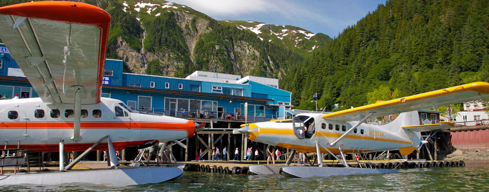
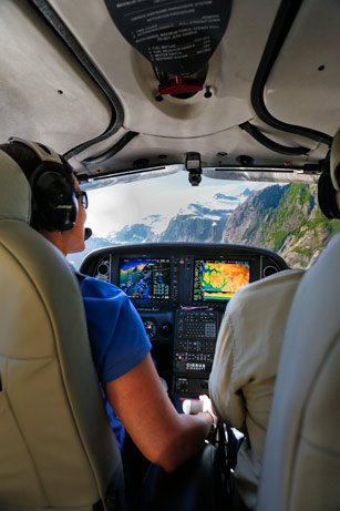
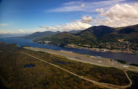
Approaching Ketchikan from the southeast also provides a glimpse of the improved situational awareness many U.S. pilots could experience beginning in 2020, when ADS-B will be required in airspace where a transponder suffices today. The G5 we’re flying already has ADS-B In and Out, and hundreds of other airplanes in this region are similarly equipped. Other ADS-B aircraft show up on our multifunction display with identifying N-numbers or airline flight codes as well as their distances, headings, and relative altitudes. I also use an iPad with a Garmin GDL39 ADS-B receiver, and it displays much of the same information.
At Ketchikan, our traffic system shows multiple ADS-B-equipped seaplanes over the busy Tongass Narrows and wheeled aircraft using the hard-surface runway.
Since the late 1990s, southeast Alaska has been a testing ground for the pioneering Capstone project that first demonstrated the utility and safety enhancements of the ADS-B system, and a high percentage of the commercial floatplanes, air charters, and regional airliners here are ADS-B-equipped. Even though the geography of the towering mountains and coastal canals means there can be little or no radar coverage at the low altitudes we’re flying, airplane-to-airplane ADS-B signals let us know each other’s whereabouts.
ADS-B ground stations have long been in place throughout southeast Alaska, so in airspace with radar coverage, aircraft with Mode C transponders also show up with relative altitudes, headings, and distances—but not N-numbers or flight codes. Commercial operators here also use an as-yet-unpublished network of IFR low-level GPS airways that allow them to navigate in the clouds through high-walled canals on cloudy days that otherwise would ground them. Since many of the towns and settlements in this region can only be reached by air or water, the ability to fly safely in inclement weather is a major plus.
The rare Alaska sunshine holds out during our flight to Klawock, a fishing village at the southern tip of the imposing Prince of Wales Island, and a day of fishing turns out to be my favorite part of the trip. The fishing is incredible, and our group lands what seems like enough salmon, halibut, ling cod, and snapper to stock the Pike’s Place Market in Seattle. But the amount and variety of wildlife around us is far more impressive.
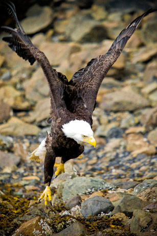
Otters and sea lions seem as curious about us as we are about them; clusters of eagles (a.k.a. “Alaska pigeons”) swoop low over schooling fish, and humpback whales gorge themselves near the shoreline. At times, the majestic, submarine-sized mammals cruise directly under our 24-foot boat and spout near enough for us to hear the roar of their hardworking lungs.
The weather forecast calls for low ceilings and rain on our departure day, and I’m secretly looking forward to an introduction to nonradar IFR flying in Alaska. From Klawock, we’re flying just 20 minutes east to Ketchikan to refuel before starting the long leg to Seattle. The procedure calls for a climb to 6,000 feet over the ocean, then intercepting the airway that leads to the final approach fix for the ILS approach to Runway 11. But as we drive to the airport, the ceiling and visibility improve to what Lysen describes as “VFRish” (about 800 feet), and it’s VFR by the time we take off. More sunshine awaits in Ketchikan.
A cooler of fish in our baggage compartment puts our airplane right at its maximum gross weight. The airplane seems not to mind, however, as we lift off the ground in 1,500 feet and climb 2,000 fpm. Our VFR border crossing goes smoothly just north of the San Juan Islands, and after 3.5 hours of flying, we’re back at Boeing Field in Seattle where this trip of a lifetime began.
“One of the most surprising things about Alaska is how accessible it is,” says McIver, whose sales territory includes the entire state. “Ketchikan is within easy nonstop range for an SR22. And Anchorage is only one tank of avgas beyond that. It may feel like the end of the Earth, but it’s within reach.”
Email [email protected]