Mention inversions and most pilots will get the general idea that these represent situations where temperatures rise with altitude rather than fall. That’s at odds with “standard” conditions, where the temperature lapse rate is pegged at two degrees Celsius/3.5 degrees Fahrenheit per thousand feet. But in nature things are seldom standard. Temperature inversions prove that.
In fact, inversions are fairly common. There’s nearly always an inversion at about 5,000 feet agl (850 millibars on a constant pressure chart) when good visual meteorological conditions exist—especially in the morning hours. Ditto for another inversion just above the surface. Why? Because radiational cooling dissipates heat near the surface on clear nights, while the air immediately aloft remains warmer. As the day warms up, the air aloft mixes with the cooler air below and the inversion disappears. Want to know a trick that forecasters sometimes use to predict daytime high temperatures? Use the temperature just above an inversion, because it will make its way to the surface during the mixing process.
Inversions promote stability in the atmosphere during the convective season because if any warm air rises, it will stop when it hits the warm air at the inversion altitude, which acts like a cap. That sounds like good news, but again, it’s not that simple. There are ways that rising air can break through this cap. For example, low-level air parcels can be so warm and buoyant that they can power their way through. That’s bad, because once the cap is “broken,” that parcel is free to keep on rising into cooler air and create thunderstorms. If you see rapidly building cumulus or towering cumulus clouds by early afternoon on a warm day, then you know that any cap has been broken and that fireworks may ensue.
But let’s say that the air in the inversion isn’t that dynamic. Instead, it stays trapped beneath the warm air aloft. Sure, there will be smooth air down there, but there can be visibility-robbing haze, smog, and low clouds. Better be current and proficient in instrument flying if you plan on flying in this soupy, low-level mess.
Winter brings more inversion-related issues. Imagine rain or drizzle falling from the warm air of an inversion layer into a layer of subfreezing temperatures below it. This is a recipe for freezing drizzle, ice pellets (sleet), or freezing rain—in other words, some of the most dangerous aviation weather. A shallow subfreezing layer is the worst. The falling rain doesn’t have enough time to freeze solid, so the rain becomes supercooled—subfreezing, yet still liquid—until it strikes airfoils and airframes and flash-freezes as clear ice. Turbulence also can come with inversions. The tops of inversion layers can act as boundary lines between turbulent layers, so climbs and descents through them can prove annoying, especially if you’re on the gauges.
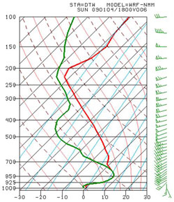
Apart from mentions by flight service briefers, the best way to identify inversions is to become familiar with websites that show Skew-T Log P charts, such as The Forecast Model Sounding Machine online. Pick the model you want (the RUC updates are more frequent), plug in the forecast time (Zulu/UTC) you’re interested in, enter the station identifier, and click on “Go make the sounding!” to see if any models foresee inversions. The plotted lines on the right are temperature; the lines to the left represent dew points.


