Recreational users of unmanned aircraft, particularly those without aviation training or knowledge of airport operations, have long faced a challenge when it comes to complying with the 2012 federal law requiring hobbyists to notify airports in advance before flying a drone within five miles of an airport. A California company has now come up with what is at least a partial solution.
AirMap, which released an online tool in 2015 that helps drone pilots determine their proximity to airports, has added new functionality that allows those same pilots to notify participating airports electronically, by a variety of electronic means.
AirMap’s Digital Notice and Awareness System (D-NAS) has so far been implemented by more than 50 airports across the country, a number likely to grow as word spreads. It will be demonstrated at the American Association of Airport Executives conference in May; AAAE includes among its members the staff of more than 850 airports, and collaborated with AirMap and leading drone makers DJI and 3D Robotics (with Yuneec expected to join soon) to develop the electronic notification tool.
AirMap CEO Ben Marcus, who is also a pilot and flight instructor, said the tool is available to operators of homebuilt drones, or those made by other brands, through the company website and a forthcoming AirMap app, the company’s first, expected to be released soon for iOS devices.
“We’ve been hearing for quite some time that it was really a hassle for people to call the airport to give notice over the phone,” Marcus explained, noting that his own experience flying drones near airports has proved compliance can be complicated. He recalled a flight made near one airport that led to several different phone calls to and from the airport management office, control tower, and staff at the local flight standards district office. All concerned congratulated him, Marcus said, on doing the right thing by notifying them of his intentions, but it struck the AirMap CEO that, after several phone calls connected to a single flight, there must be a more efficient way.
“I realized that this was just not a scalable process for anybody in this ecosystem,” Marcus said in a telephone interview. “Density and sophistication of drone operations is just going to grow massively.”
Getting the word to those who need it most, particularly pilots flying with drones nearby, is the core purpose of the notification system Marcus and his team created.
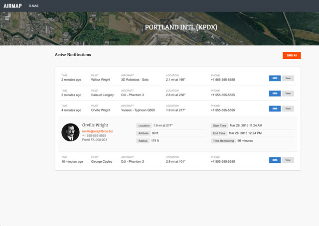
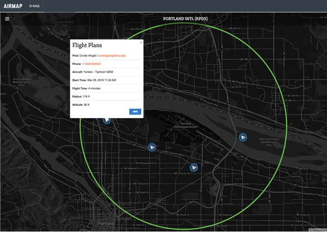
“We need to make that easy to do across the National Airspace System,” Marcus said. The D-NAS dashboard allows airport management and air traffic control to view nearby recreational drone operational plans in real time through an electronic dashboard. (Commercial operators are required to file notams in advance of their operations.) Marcus takes pride in having forged partnerships with leading manufacturers (the three companies that have adopted or agreed to implement D-NAS to date account for the vast majority of consumer and recreational drone sales) that will integrate the digital notification system into manufacturer-produced apps already used by operators to control their drones.
“Through those connections really millions of people will soon be using our services,” Marcus said. “That’s really the important metric.”
The FAA continues to receive roughly 100 reports each month of drone sightings, including many from flight crews or others who report unmanned aircraft (or suspected unmanned aircraft) operating very close to (or directly over) airports. Some stray into the most dangerous areas, approach and departure paths.
D-NAS allows users with connected devices (via cellular or Wi-Fi) to announce their intentions, and also asks for their mobile phone number to facilitate contact from ATC or airport staff in case of need.
The tool is the latest addition to a coordinated effort by the FAA and industry to educate drone pilots, particularly hobbyists, many of whom have little or no flight training or aeronautical experience. AirMap has also released a software development kit that allows makers of drone-related apps to add the notification system functionality to their own software.
“Participation in the D-NAS pilot was a no-brainer for us. In the face of growing concerns over UAS operations near airports, AirMap has developed an effective and unique solution,” said Steve Runge, division manager for the Houston Airport System, in a news release. “D-NAS is a game changer for how we will manage low altitude air safety.”