Blown away
Reading wind, the old-fashioned way

 Windsockology—reading the wind in cloth
Of course, if my stupid windsock hadn’t blown away, it would have been my best source of low-tech wind info. But it’s really not so low-tech as it seems. The simple sock can tell us not only direction, but wind speed. If you know how to read it.
FAA-approved windsocks come in both 8-foot and 12-foot models, and Advisory Circular 150/5345-27E specifies how they must respond to the wind. The FAA says that approved socks must spin freely when subjected to a wind of 3 knots, and be fully extended at 15 knots. Oddly, the FAA offers no specific guideless for the position of the sock between 3 and 15 knots, but most pilots presume a half extended windsock indicates wind around 7 knots. These numbers are for the approved airport windsock sizes, so the miniature one on your back porch may not be the same.
Meanwhile wind cone assemblies, per the FAA, must be able to withstand wind speeds of 75 knots. So if you witness the windsock and pole blow away, you might want to go land somewhere else.
Transport Canada, on the other hand, specifies the windsock’s position for winds between 3 and 15 knots. At 10 knots the sock should be 5 degrees below the horizontal, and a 6-knot wind must cause the sock to be 30 degrees below the horizontal—not too far off from our common wisdom.
Striped socks, more common in marine applications, but seen at some airports, indicate 3-knot increments at each stripe, allowing you to simply count how many stripes are “blowing” in the wind. —WED
JARGON: WIND SHEAR
Wind speed and direction often differ between the surface and at altitude. If the winds aloft are dramatically different from surface winds, however, that’s a sign you may encounter wind shear. The Pilot’s Handbook of Aeronautical Knowledge describes wind shear as “a sudden, drastic change in wind speed and/or direction over a very small area.” Low-level wind shear is especially dangerous.
Santa Rosa Route 66 Airport,automated weather observation,one five zero three Zulu.
Wind: Missing.
Visibility: Missing.
Sky conditions: Missing.
Temperature: Missing.
Dew point: Missing.
Altimeter: Missing.
Now what? I guess I’ll have to use the ol’ wind sock. Oh. Wait. We don’t have one. A storm shredded it almost a week ago, and the replacement isn’t up yet. So how to decide which of the four runways to choose?
Luckily for me, determining wind direction and speed in the absence of technology old or new isn’t rocket science. The ground below is riddled with clues telling us about the wind that’s stroking its face.
Direction
A distant ancestor of my missing wind sock is the flag. Any decent sized flag is large enough to be easily seen from the air. Many are actually larger than official airport windsocks, which are either 8 feet or 12 feet in length. The size of a typical public flag depends on the height of the pole, but ranges from 3 feet by 5 feet to 10 feet by 15 feet for most buildings—although some malls, shopping centers, and truck stops fly flags as large as 30 feet by 60 feet. For what it’s worth, the largest flag in the country is 70 feet by 140 feet, and flies atop a 400-foot navigational hazard of a flag pole in Sheboygan, Wisconsin.
That’s taller than the Statue of Liberty. But I digress.
Like a wind sock, a flag points in the direction that the wind is blowing—downwind in pilot parlance. But it’s not just flags we can use to determine the direction of the wind. Anything that floats in the wind provides clues to its direction: smoke or steam from industrial sites, dust from cars driving on country roads or farmers plowing their fields, ribbons of snow blown loose from the ground in winter. Likewise, the flow of wind can be seen in fields of tall grass and grain, in the motion of trees, and even across the face of water.
Cows generally face away from the wind, although horses tend to face into it, so be sure which critters you’re looking at. Wind farms, which are popping up across the middle of the country like mushrooms after the rain, point their spinners into the wind, their boxy generator housings pointing downwind.
And, of course, when flying cross-country, taking note of any crab angle needed to keep on course gives you a sense of wind direction.
So that’s all good and fine, but wind direction is only half the information you need, right? Knowing that the wind is more or less from the east doesn’t help all that much on a north/south runway if you don’t have some clue how strong that wind is, right? So how do we determine the velocity of the wind?
Speed
Let’s go back to the flag. Like a windsock, a flag can indicate wind velocity as well as direction, and there are two ways to read them: one that requires some math, and one that doesn’t. The math-free way is called the Beaufort Method, after Francis Beaufort, who standardized wind observations for the Royal Navy in the 1800s. His original concept, naturally called the Beaufort Scale, dealt with wind on cloth sails, but over time it’s been modified for a variety of surface observations—including flags, foliage, and wind effects on water.
In regard to flags, the accepted wind effect is that flags start flapping at 10 knots. So a limp flag doesn’t even signal a wind that could have an effect on a Light Sport GA aircraft. “Light and sporadic” flapping indicates wind 10 to 16 knots. If the entire length of the flag is in movement the wind is 17 to 21 knots. A partially extended, rapidly flapping flag indicates wind 22 to 27 knots. If the flag looks like it’s been ironed onto the sky, fully extended, the wind is in the 28- to 32-knot range.
If the flag is missing, you probably should’ve stayed home.
The Beaufort Method is intended for use on heavier flags, like the kind that historically flew over military posts, not the little polyester jobs on a patriot’s front porch. And, no, I have no idea if the Beaufort Method works on that 340-pound monster flag in Sheboygan, but if it’s missing, you definitely should’ve stayed home.
The more mathematical method may not be practical from the air, but military marksmen estimate wind (for windage in shooting) by dividing the angle between the bottom of a flag and the flag pole by four to get the wind speed in miles per hour.

Illustration by Kevin Hand
Tech tip
At your fingertips
Understanding cockpit weather information
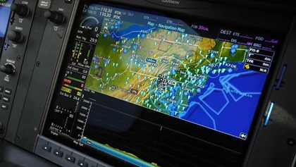 Weather information on electronic flight bag apps or panel displays can help improve yoursituational awareness and understand changing weather—but it’s important to understand when you’ll have access to that information. Most popular flight planning apps will download the latest wind when you’re connected to the internet, but you may not have cell reception at altitude. Subscription-free Flight Information Services-Broadcast (FIS-B) weather data is available in flight to those equipped with Automatic Dependent Surveillance-Broadcast In (ADS-B In), and more robust weather data is available via a subscription service such as SiriusXM.
No flag? No problem. Lots of natural anemometers on the ground can be spied from the air. The National Weather Service’s guide to estimating wind speeds includes these items, usually shown in miles per hour but converted to knots to be pilot-friendly:
- 0.5 to 2.5 knots: Smoke drifts, but flags are becalmed.
- 7 to 10 knots: Flags ruffle and extend.
- 11 to 15 knots: Dust becomes airborne.
- 16 to 21 knots: Large branches and small trees begin to sway, crested wavelets form on inland lakes and large rivers.
- 22 to 27 knots: Large branches are in continuous motion.
- 28 to 33 knots: Whole trees are in motion.
Waves on the ocean or large bodies of water allow for the most accurate estimation of wind speed:
- 1 to 2.5 knots: Lightly rippled surface.
- 3.5 to 6 knots: Small wavelets or scale waves.
- 7 to 10 knots: Long unbreaking waves.
- 11 to 16 knots: Waves with some whitecaps.
- 17 to 21 knots: Moderate waves with many whitecaps.
- 22 to 27 knots: Larger waves with regular whitecaps.
- 28 to 33 knots: Large waves, “heaving sea.”
- 34 to 40 knots: Blowing foam.
There isn’t any scientific way to estimate wind speed by the movement of grasses in fields, other than the obvious observation that if an entire field is moving in a way that makes it look like it’s being invaded by an army of giant snakes, you know the wind is high.
Then there’s the barnstormer method: Use any method to determine the wind direction, point the nose of your airplane that way, and compare your groundspeed to your airspeed to estimate the wind velocity. Caveat: This only gives you the wind speed at your altitude, not its speed at the surface, which is often quite different, so the lower—within the FARs—that you check the wind using the barnstormer method, the better for your landing.
But looking down at the ground isn’t the only way to determine the wind direction and velocity. Inside our cockpits we can leverage a range of technology to learn more about the wind.
Cockpit Tech
Of course, at one point in your aviation life you had to prove that with groundspeed, course, heading, and airspeed you could figure out wind direction and velocity using a good old-fashioned E6B flight computer. But if you’ve forgotten how, or you sold your E6B on eBay, there are still other options in the cockpit.
Looking at our portable electronics, most popular flight planning apps report wind data, and if the local AWOS is out, you’ll still be able to look up nearby airports that are otherwise out of radio range. Alternatively, if you’ve got cell service at your altitude, you can simply look up local wind speeds reported by personal weather stations near the airport on websites or apps such as Weather Underground.
Many modern glass cockpit displays calculate wind speed and direction for you, but you still have options if your GPS doesn’t. There’s a ton of talk in pilot chat rooms about how to use GPS to determine wind speed and direction. On the complex side is the Horseshoe Heading Technique of David F. Rogers that involves some serious math, 10 steps worth; a simpler technique involves flying a 360-degree turn while monitoring groundspeed, noting the slowest point as the direction the wind is coming from, then applying some straightforward mathematics to the minimum and maximum ground speeds to determine the wind speed.
But the point being missed in all these online discussion boards is that the wind at cruise and wind at the surface are rarely the same.
Coming in to land
Failing all else, make a low pass over the runway. The crab angle necessary to keep on the runway centerline is a good predictor of the crosswind, and thus the effort needed to land in it.
Flags, cows, dust, wind on the water, a smartphone: There’s no shortage of ways to weigh the wind in the absence of the AWOS and the windsock.
William E. Dubois is an aviation writer, world speed record holder, and two-time National Champion air racer.www.PlaneTales.net.


