Get extra lift from AOPA. Start your free membership trial today! Click here

All-winter backcountry access

Hells Canyon airstrips in Oregon, Idaho

The greatest concentration of backcountry airstrips in the Continental United States is found in the Northwest. Idaho has by far the largest number, mostly due to the diligence of Idaho pilots who have banded together to work with state and federal agencies and land owners to keep airstrips open on public and private lands. Unfortunately, most Northwest backcountry airstrips are inaccessible for at least half the year, due to a combination of high latitudes and mountain altitudes. But savvy backcountry pilots who enjoy winter flights know where the snow-free strips are—in Hells Canyon.

  • A beautiful Super Cub sits near the north, or downstream, end of Runway 13/31 at Dug Bar, on the Oregon side of Hells Canyon. Although this airplane has bush tires, tricycle-gear aircraft with normal-sized tires can land at Dug Bar. Inside Hells Canyon, the Snake River flows north toward Lewiston. Always monitor and make position reports on 122.9 when in the Idaho backcountry. It is imperative to note and use extreme caution for two power transmission lines that cross the canyon three miles downstream (north) of Dug Bar. They cross the canyon at mid-level and are marked with balls but difficult to see. Do not fly under them! If arriving from the north, many local pilots fly over the power line tower on the canyon’s west side to be confident of safe clearance. Photo courtesy Bill Miller.
  • A gorgeous Cessna 170 at Dug Bar in December 2016. Even when it snows at the bottom of Hells Canyon, it’s often light enough that the strips are still useable. Do not fly into Hells Canyon except in VMC. If clouds are hanging on, or just above, the mountaintops and it is clear below, you will have thousands of feet of clearance to fly in the canyon, but this is not advisable unless you are familiar with the area. Winds can cause turbulence inside the canyon: if winds aloft at 9,000 feet exceed 25 knots, it’s best to scrap a canyon flight. Photo by Bill Ables.
  • Big Bar airstrip, looking south, or upstream, on January 1, 2012. Members of the Idaho Aviation Association used to hold a New Year’s Day fly-in here each year, but it’s been moved to Dug Bar, 20 miles downstream (north), a less-challenging airstrip. Only three roads reach the river inside Hells Canyon: Hells Canyon Road at the dam, Deer Creek Road at Pittsburgh Landing across from Pittsburgh airstrip, and Imnaha Road, which leads down to Dug Bar. Photo by Crista Worthy.
  • If you land at Big Bar on the Idaho side of Hells Canyon, you can walk about 3 miles north to the historic Kirkwood Ranch where you’ll find several well-preserved buildings. One is a small museum that features artifacts and photographs illustrating the area's history, flora, and fauna; another is a well-outfitted blacksmith shop. If the resident hosts are there they might show you the unusual bathtub in the house, mentioned by Grace Jordan in her book, “Home Below Hells Canyon.” The Jordan family raised three children at the ranch during the Depression-era early 1930s; Len Jordan later became Idaho’s governor and then a U.S. Senator. The hike is mostly along the river; at Suicide Point you’ll enjoy fine views of Hells Canyon. Note the snow on the peaks; this photo was taken in mid-March. Photo by Bill Ables.
  • Starting the takeoff roll down Runway 31 at Cache Creek, on the Oregon side of Hells Canyon near the Washington border. With a 10.26-percent slope, landings are made upstream and uphill on Runway 13. Volunteers recently installed a new windsock. Use caution not to snag a wingtip on the uphill bank. Currently an administrative site for river permits, the visitor’s center is staffed year-round. Plus, there are beautiful views from the front lawn, picnic tables, and hiking. Even though they have a dock, seaplane landings are not allowed within the Hells Canyon corridor. Photo by Bill Ables.
  • These seaplanes are docked in front of the popular Rooster’s Landing restaurant in Clarkston, Washington, on the Columbia River immediately downstream (west) from its convergence with the Snake, where seaplanes are allowed to land. It’s the most-westerly of three adjacent docks in front of a golf course. Photo by Alan Bobo.
  • Aerial view of Dug Bar, just after volunteers installed a new windsock and mowed a new Runway 13/31 (with white-painted end markers) that is generally safer than the old Runway 14/32 (which can still be used). Photo was taken in April, when Hells Canyon was a verdant green. Complete runway, historical, and recreational information on all the airstrips in this article can be found in the two-volume set, “Fly Idaho! 3rd Edition.” Photo by Crista Worthy.
  • Bill Miller lands his Cessna 182 at Dug Bar. There are two schools of thought when flying Hells Canyon. Some pilots prefer to stay high, leaving an escape route until over the destination airstrip, and then spiral down. The canyon is plenty wide above both Temperance Creek and Dug Bar for this. However, we have always let down gradually into the canyon; a 500 fpm letdown is comfortable for most passengers. You aren’t the requested 2,000 feet agl inside a National Recreation Area, but you’re descending so that’s allowed. When using this technique, plan on being at about 7,000 feet msl 20 nm from your destination airstrip. A forced landing will likely be in the river; most backcountry pilots carry a PLB. Speed control is important too; flying slower allows you and your passengers to look around for the numerous mountain goats and elk inside the canyon; often you’ll see waterfalls cascading hundreds of feet down the rocks. It also provides more reaction time, is safer in turbulence, and decreases your turning radius if you decide to turn around. Photo by Crista Worthy.
  • Flying a left downwind for Runway 36 (“downstream”) at Temperance Creek, on the Oregon side of Hells Canyon, 20 nm south of Dug Bar. A right downwind might be a better option, to allow more space for turning around. Note the shorter Big Bar airstrip across the river on the Idaho side. The close of the last Ice Age brought a series of great floods in Hells Canyon. Rock slides and ice dams had created large natural reservoirs, backing up water and sediment. Each time an ice dam gave way, the Snake River cut a fresh path through the sediment, leaving huge bars above the river’s flow, where the airstrips sit today. Photo by Crista Worthy.
  • Short final for Runway 36 (“landing downstream”) at Temperance Creek. Email the ranch for prior permission to land. Pilots usually fly over the airstrip to check for hazards and wind direction at about 500 feet agl. A lower pattern, if safe, allows you to fly a tighter base while not having to lose so much altitude and still keep a little power on that you can pull off if necessary. Most pilots announce their landing direction on 122.9 as upstream or downstream, rather than the runway numbers. Photo by Crista Worthy.
  • At Temperance Creek, park on either side of the runway, near the north end. At any backcountry airstrip, always push your airplane well away from the runway. Pilots who fly in here can enjoy meals, lodging, and hiking. Hells Canyon Packers can arrange guided fishing, hiking, hunting, rafting, or jet boating trips. Photo by Alan Bobo.
  • Temperance Creek Ranch. The lodge has a kitchen, comfy living room, dining room, covered outdoor dining, outdoor soaking tubs, plus two rustic bunkhouses (red buildings). The shower house is the red building shown farthest to the left. Ranch-fresh eggs, biscuits and gravy, smoked pulled pork, and freshly-baked breads and desserts are some of their specialties. Photo by Shelly Tippets.
  • This little black bear is stealing a pear from the Temperance Creek orchard. The lovely creek flows just behind the ranch house. Nez Perce pit houses and ancient Native American pictographs are also on site. Photo by Shelly Tippets.
  • A big tom wild turkey shows off his feathers near Temperance Creek Ranch; these are seen almost daily. Fishing for steelhead, sturgeon, salmon, rainbow trout, and smallmouth bass is excellent at Temperance Creek, but you need an Oregon fishing license. Photo by Shelly Tippets.
  • These female elk are bickering right outside the Temperance Creek Lodge. Elk are often seen in large herds on the slopes above the ranch, especially in the cooler months. Other wildlife to look for, both on foot and as you fly in and out of the canyon include bighorn sheep, mule deer, and mountain goats, which are easy to spot in their bright white coats. Photo by Shelly Tippets.

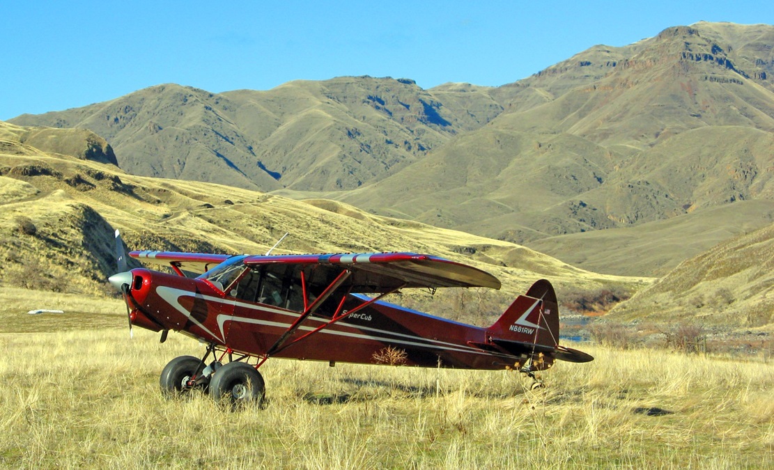
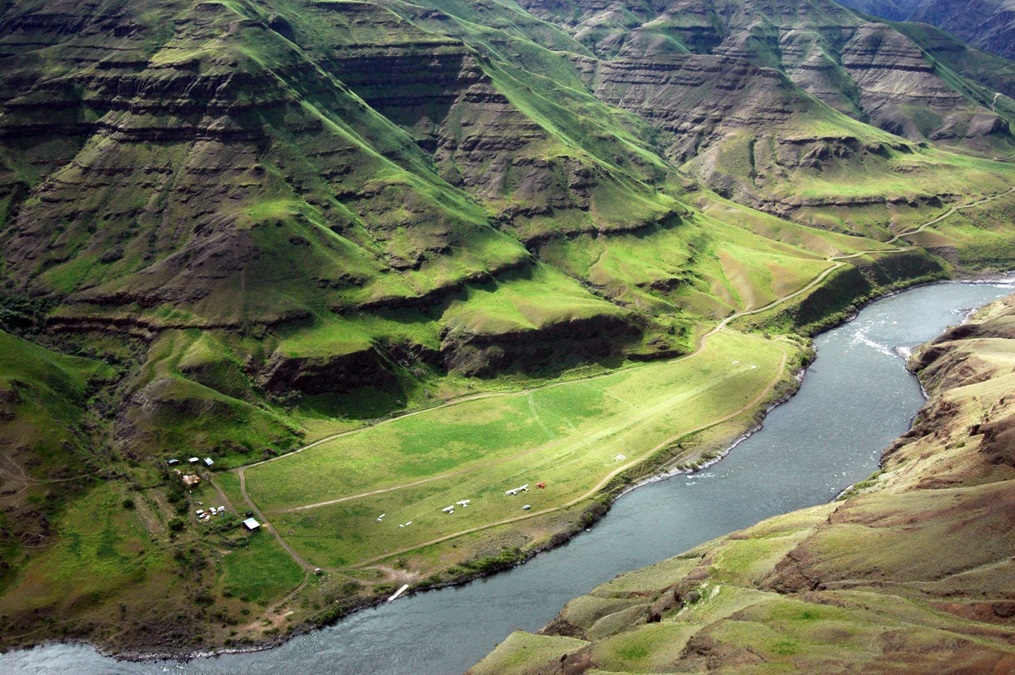
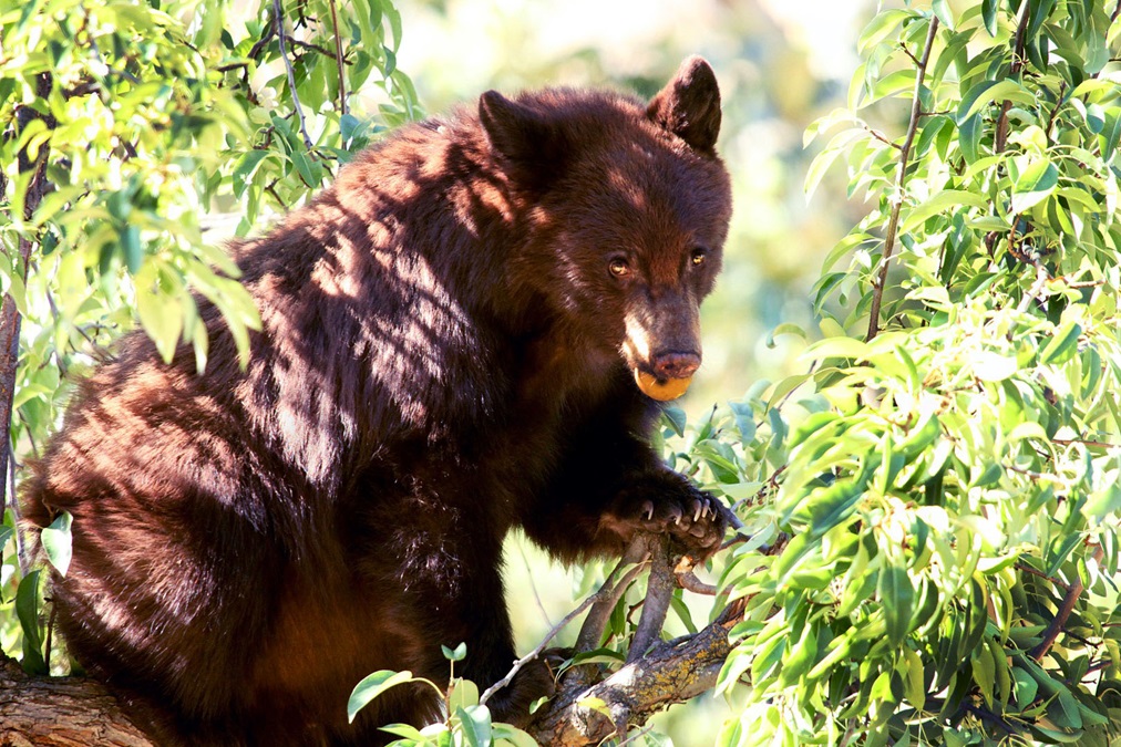
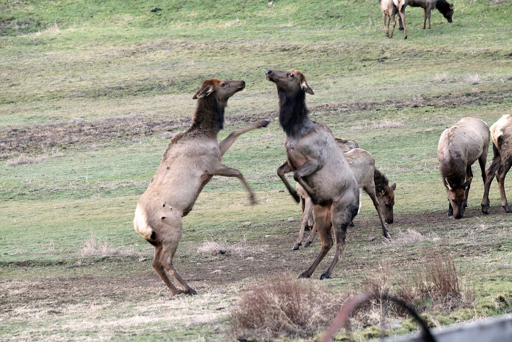
Carved by the Snake River, Hells Canyon forms part of the border between Idaho and Oregon, and is North America’s deepest river gorge: 7,993 feet from He Devil Peak to the river. The Memaloose and Lord Flat airstrips, perched precariously near the rim’s edge on the Oregon side, can be snow-covered well into June, but airstrips inside the canyon, which sit on sandbars above the river, are usually available all year. Land on a Hells Canyon airstrip and you can enjoy excellent hikes and wildlife viewing; fish for steelhead, sturgeon, or bass; or simply revel in the rugged beauty and solitude.

In an agreement with local authorities, Idaho Aviation Association (IAA) volunteers install an outhouse at Big Bar, on the Idaho side, each fall, removing it again in spring when Hells Canyon is generally too hot to visit. That airstrip, however, is short (1,471 feet) and requires high skill levels and the right type of aircraft. Other Hells Canyon strips are also short: Salmon Bar is only 700 feet; Pittsburgh has two runways, 1,050 feet and the other just 850 feet. Cache Creek is 1,433 feet but steep and bumpy with doglegs; Rogersburg is closed Nov. 15 to March 1 each year to protect nesting eagles; Sluice Creek is for emergency use only.

A section of the Idaho Aeronautical Chart shows all the airstrips mentioned in this article, all of which lie near the Oregon/Idaho border except Rogersburg, on the Washington/Idaho border. Note the location of the cable crossing between Dug Bar and Salmon Bar. Courtesy Galen Hanselman, Q.E.I. Publishing.

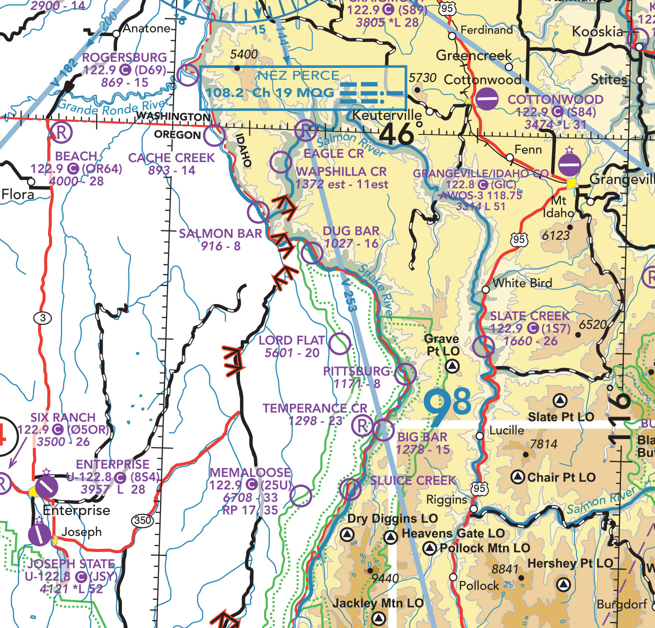
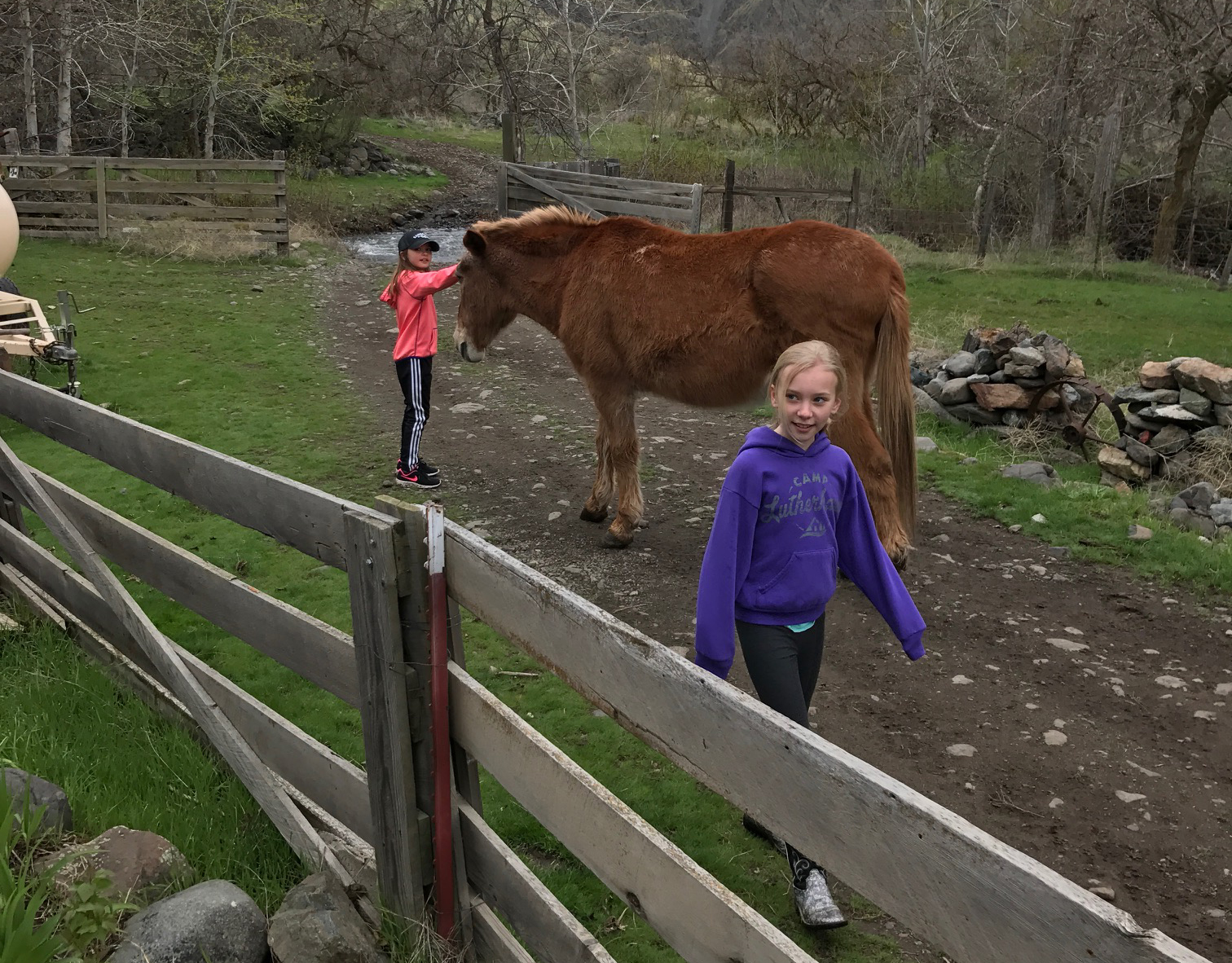
Two Hells Canyon airstrips, however, offer longer runways and safer approaches. Dug Bar is 20 nautical miles north of Big Bar on the Oregon side of the Snake, with a 1,645-foot runway that allows approaches or departures to be made from either end. You don’t need a “bush plane” to operate here. Meanwhile, Temperance Creek, directly across the river from Big Bar, is the Cadillac of Hells Canyon airstrips, with a 2,350-foot runway that can be approached from either direction and a wonderful guest lodge with great down-home cooking. You can even go for a guided hunting, fishing, hiking, or photography trip with Hells Canyon Packers, based at the Temperance Creek Lodge.

Before you go, buy the book almost every Idaho backcountry pilot carries in the cockpit: Fly Idaho! 3rd Edition. Inside, you’ll find complete information and photos of Idaho’s airstrips, plus those across the Oregon border, like Dug Bar and Temperance Creek. Order a copy of the Idaho Aeronautical Chart too, because it shows the locations of many strips not shown on FAA sectionals. Study the photo captions in this article for important flight, safety, and seaplane information.

Alanis and Emma know that Festus, the 30+-year-old mule at Temperance Creek Ranch, loves to have his head scratched. Festus and the ranch’s other friendly mule can usually be found hanging out near the lodge. Photo by Alan Bobo.

At Dug Bar, camping is free and you can fish from shore, though you need an Oregon fishing license. In January, steelhead frequent a large rapid downstream from the strip. Bass and salmon are also caught; in summer during slow water, people fish for sturgeon and carp. Hiking is excellent from Dug Bar; try the Nez Perce (Nee-Me-Poo) National Historic Trail up to Lone Pine Saddle for great views, or follow the river upstream on the Oregon Snake River Trail.

Temperance Creek is a private runway requiring prior permission; email Sarah or Abby. (Note the Big Bar airstrip directly across the river on the Idaho side.) Fly-in meals, especially breakfasts, are popular at Temperance Creek because the food is so good—but please email first, don’t just drop in. Spend the night at Temperance Creek Lodge and you’ll enjoy an isolated, rugged natural setting without giving up the comforts of home. Strike out on your own or hunt or just explore with Brice or Barry Barnes of Hells Canyon Packers, who know this area intimately.

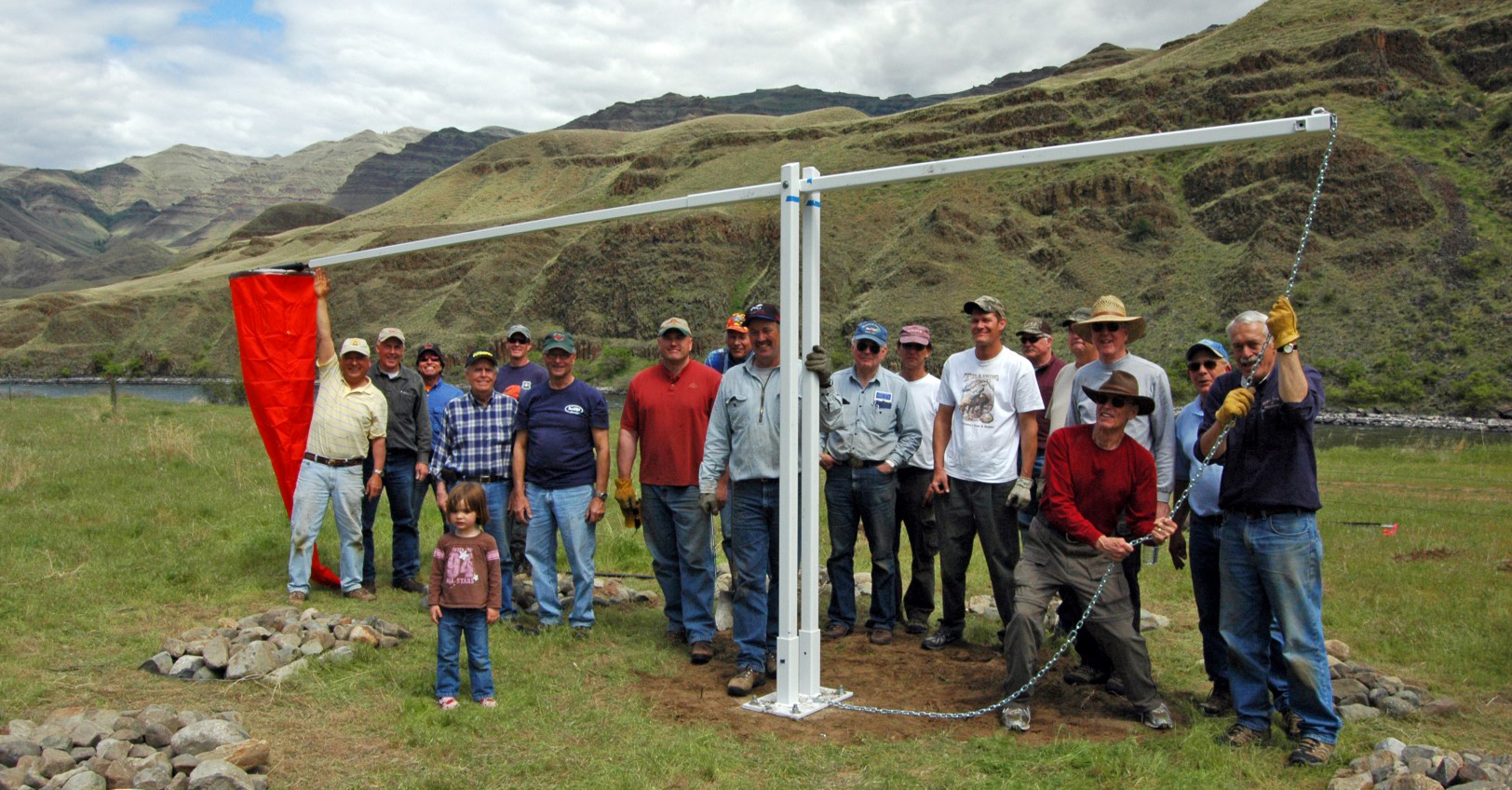
If you have even a little interest in backcountry or recreational aviation, then you’ll want to know about the IAA, which recently fought and won the right for pilots to continue use of the “Big Creek 4” airstrips in central Idaho (full disclosure–I edit their newsletter, The Flyline). The IAA website also provides a list of flight instructors who specialize in mountain and canyon flying. Enjoy Hells Canyon—see you around the backcountry!

Much of the work to maintain the Hells Canyon airstrips is done by volunteers like these from the Idaho and Oregon pilot’s associations, who, in cooperation with the Idaho Division of Aeronautics, U.S. Forest Service, and others, installed a new windsock at Dug Bar in April of 2012. Photo by Crista Worthy.

Share your favorite destination in the AOPA Hangar: Places to fly, things to do, where to eat!

Crista Worthy

Crista V. Worthy

Crista V. Worthy has been flying around the United States with her pilot-husband Fred and their children since 1995, and writing about fun places to fly since 2006. She has single-engine land and sea ratings. Her favorite places to explore are the backcountry strips of Idaho and Utah's red rock country. She currently lives in Idaho and serves as editor of The Flyline, the monthly publication of the Idaho Aviation Association.
Topics: Travel, U.S. Travel

Related Articles