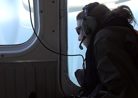
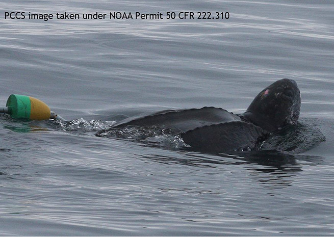
Eyes strained to spot a tiny dot among ocean swells stretching to the horizon. Somewhere below, quite possibly within view, a sea turtle was tangled in fishing gear, a fatal condition more often than not. A latitude and longitude of unknown accuracy and age were used as the starting point, the DHC-6 Twin Otter flying concentric circles from it in a long-shot effort to find the turtle and guide a rescue.
A phone call to fisheries biologist Christin Khan had prompted a change in plan, though the planned mission remained essentially the same: a short out and back from Barnstable Municipal Airport in Hyannis, Mass., to demonstrate what the Twin Otter can do. Khan, having just returned from an hours-long orbit over offshore waters in search of whales, was preparing to drive home when the call came in. She consulted with Lt. j.g. Mike Hirsch (an ensign at the time), the aircraft commander and a member of the National Oceanic and Atmospheric Administration’s small corps of commissioned “environmental intelligence” officers, to use an apt if unofficial term. Hirsch agreed that finding the stricken Leatherback was worth an attempt, though the odds were slim. Though large as turtles go, the distressed animal—called in by boaters—was significantly smaller than the Right Whales being tracked out of Hyannis and a building offshore wind was whipping up waves and white caps that made the already difficult task of finding anything smaller than a steamship next to impossible.
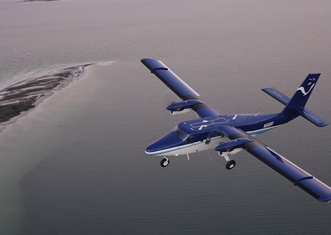
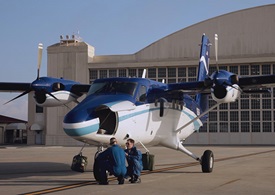
This Twin Otter, one of four in the NOAA Corps fleet, was well suited to the attempt. Windows in the passenger cabin were fitted with clear domes bulging from the fuselage, large enough for an observer’s head and shoulders, allowing a wide field of view. On other missions, an even larger dome in the belly can be fitted with survey cameras. NOAA has found many applications for the Twin Otter’s low-and-slow abilities, observing and photographing a range of marine animals, surveying coastlines, documenting mountain snowpack to support flood forecasting, and conducting damage assessments in the wake of storms like Hurricane Sandy.
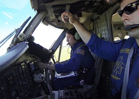
Ensign Kerryn Schneider deployed 10 degrees of flaps at Hirsch’s request, and confirmed there was adequate speed to begin a steep turn, one of many such cross-checks.
“Flaps set at 10,” Scheider reported crisply.
“Thank you.”
Her head and shoulders scrunched into a spot that would be blasted by slipstream in other aircraft, Khan spoke up, a spark of curiosity in her voice over the intercom:
“Hey, can we go to the right? It’s probably just a small vessel at 2 o’clock. I don’t know … can we head that way for a minute?”
A glum tone of voice would return as the smaller of two vessels below came into clearer view. “Yeah, it’s probably a boat. It’s some kind of boat. Never mind. Caught my eye.”
“No problem-o,” Hirsch said, returning to a previous task: demonstrating for a reporter how the Otter can turn tight circles over objects of interest, a buoy, in this case, for lack of anything else.
‘The flying trapeze’
If the hurricane-hunting P-3 Orions are the darlings of television networks, as the alphabet soup of bumper stickers inside attests, the Twin Otters remain the first love of many NOAA Corps pilots. They decorate the cockpits with pairs of stuffed (toy) otters perched inside the windshields, facing the pilots. They speak fondly of the airplane’s predictable and steady habits.
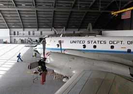
“None of us really ever want to get away from the Twin Otter because it is that much fun to fly,” said Lt. David Cowan, echoing the sentiments of many pilots interviewed at the NOAA Aircraft Operations Center, housed in a hangar at MacDill Air Force Base in Tampa, Fla. “We jokingly call it the flying trapeze, because it literally is so stable at slow speeds.”

That is not to say the missions offer the greatest of ease: Cowan has flown the length of Alaska’s Aleutian Islands, surveying marine mammals like the Steller sea lion, which has a penchant for narrow beaches flanked by steep volcanic cliffs. Pilots must carefully maneuver for an overhead shot, banking to get the right angle for the belly-mounted camera while taking care to avoid the rocks.
“You fly within about a wingspan or two distance from the edge of the mountain,” Cowan said, and then paused to reconsider. “Maybe it's a little further than that, but that's what it seems like in the plane.”
Over the Alaskan islands, Cowan and other pilots must learn to cope with williwaws, ferocious winds created when air cooled by snow and ice descends a steep slope. Those katabatic winds have been known to exceed 100 mph, and make flying close to cliff faces arguably just as dangerous a proposition as penetrating the heart of a hurricane. Despite such risks, NOAA has maintained a near-spotless safety record by carefully assessing such risks through a collaborative approach. Each mission is planned in exhaustive detail, with a systematic, written analysis of risk factors and mitigation strategies that is reviewed throughout the chain of command. The collective knowledge and experience of the group is applied to imagining what can possibly go wrong, and what can be done to avoid trouble.
This process, known as “operational risk management,” is used throughout the organization, according to Capt. Randy TeBeest, now retired, who was preparing to hand over command of the aircraft fleet to Capt. Harris Halverson during a visit earlier this year.
“We use ORM at every level in this center as a decision-support tool,” TeBeest said. “What we’ve learned here is that formalizing that process, verbalizing it, using teams to look at various missions (as opposed to) one person, really raises the value of that tool.”
Pilots develop spreadsheets that stretch for pages, noting each risk factor and a strategy to address it. Long-endurance missions call for auxiliary fuel tanks, and a plan for alternate airports in case of need. Weather and aircraft limitations are considered, along with options available in case things don’t go according to plan. Each mission plan is then circulated among the pilots, boiling down to one final question that must be answered in the affirmative by the overall commander, a task TeBeest has since passed to Capt. Harris Halverson to continue the tradition based on a simple question:
“Do we feel like we can do this responsibly and safely?”
TeBeest began his NOAA career in 1992, and could recall only one fatal accident—involving a helicopter operating in the Arctic—which predated his tenure. There have been no NOAA aircraft or crews lost since, despite logging many hours penetrating hurricanes, avoiding cliffs, and stretching the legs of their aircraft on hours-long missions far out over hostile seas.
“The one thing we keep in mind is that we’re never safe enough. It’s not something we ever want to become complacent with,” TeBeest said. “That’s a maturation of the organization that I’ve seen over the years.”
A busy airplane
Their eyes may glint a bit when describing the more challenging missions, though NOAA pilots—several of whom were interviewed at length in Tampa, and in Hyannis, where the Northeast Right Whale Project is based—do not come across as risk-takers.
“What I’m looking for is, can that pilot know his limitations in the plane, and make sure that they can circle, in our case, at a safe airspeed, and know when it’s not a safe situation,” said Lt. j.g. Robert Mitchell, who serves as a Twin Otter instructor and the lead point of contact for its various operations. While the Twin Otter is ideally suited for the steep, slow turns at low altitude that are a common denominator of wildlife surveys and coastline photography, Mitchell said there is still a thin margin “between flying and not flying.”
Crews are trained to “back each other up,” Mitchell said, describing a culture of collaboration that extends from the evaluation of weather and a consensus decision to launch, into the cockpit. It is everyone’s job to speak up if danger or an unsafe condition is spotted, and the collaborative approach is illustrated during each takeoff, when both pilots take hold of the power levers, each ready—and empowered—to react instantly to the unexpected.
It is a disciplined approach to safety similar to the crew resource management and risk management techniques used by many professional and military aviators. NOAA Corps draws many of its pilots from military ranks, though not all. Some have been trained in civilian settings, earning college degrees with a healthy dose of math and science. Some served for two years or more on NOAA ships at sea before being selected for flight training.
Cowan, who studied meteorology and aviation at Embry-Riddle Aeronautical University, joined the corps four years ago, having heard about the little-known opportunity from a professor. He said competition is increasing, the applicant pool roughly doubling in size to 100 or more since he was selected.
Cowan is transitioning to the Gulfstream IV used for high-altitude hurricane study (the P-3s probe the low-level winds), but looks forward to staying with the aircraft where nearly every NOAA aviation career is launched.
“You never really get away from the Otter … it does fly all year round. It's a very busy airframe,” Cowan said. “I wouldn't want to give it up, either.”
In January, NOAA officer candidates began training at the U.S. Coast Guard Academy, where future generations will learn military discipline, seamanship, and other mission-critical skills such as cold water survival and rescue.
This was a point driven home during a lengthy safety briefing conducted by Lt. j.g. Kevin Doremus, an ensign at the time who prepared a reporter to ride along on a January whale survey out of Hyannis. Though that mission would be scrubbed by an offshore sea state not conducive to observation, Doremus and Lt. j.g. Sandor Silagi were happy to show how to don the survival suit worn at all times during cold-weather operations. If something goes wrong at 700 feet above the waves and the aircraft is forced to ditch, there will be no time to struggle into such a suit before swimming in the frigid North Atlantic. Unlikely, to be sure—both the Twin Otter and its Pratt & Whitney PT-6 turboprop engines are renowned for reliability—but survival suits are mandatory.
A reporter struggled to zip up the tight-fitting hood, pondering the potential loss of body weight from sweat during a mission that typically lasts many hours, an auxiliary fuel tank taking up the space of three seats inside the cabin. Both pilots applauded as the stubborn zipper finally pulled closed leaving only the eyes and nose exposed.
“That’s a good look for you,” Doremus said, grinning.
‘A wonderful opportunity’
NOAA Corps Twin Otter pilots quickly get used to hotels, spending months at a time on the road. Aircraft and crews rotate through assignments that can last up to two months in one location, then move on to follow a migrating population, sample air quality, photograph storm damage, or update a vast geographical database.
Hirsch, for one, embraces that lifestyle.
“My personal apartment that I am renting is just a storage locker, because I don’t want to see it at all,” Hirsch said. “I asked them to put me on the road 365 days a year if possible.”
Not every pilot is quite that enthusiastic, though all adapt to trading the comforts of a fixed home base for the adventure of flying for science.
“It's a wonderful opportunity for aviators who are interested in an environmental application,” Cowan said.
Over the ocean waters south of Cape Cod in July, the search for the turtle ended with no joy, though the turtle would be found, and rescued, the following day.
The NOAA Commissioned Corps uses a risk assessment tool called “operational risk management,” a systematic evaluation of conditions and potential risks detailed in lengthy spreadsheets.
AOPA’s Air Safety Institute offers general aviation pilots a similar tool, if not quite so exhaustively detailed: Check out the online Air Safety Institute Flight Risk Evaluator to take advantage of a similar preflight check—it’s free to AOPA members and registered users.


