Pilot Briefing: Chart Challenge
Passing the mountain’s saddles, conquering its peaks
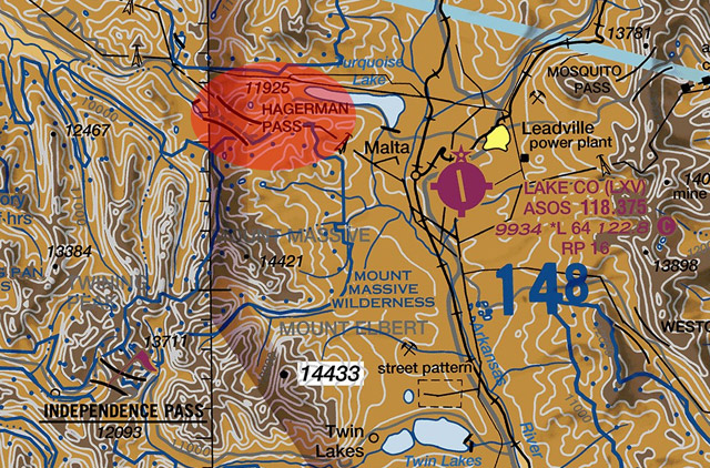
If flying in the mountains—even visiting Lake County Airport (LXV) in Leadville, Colorado (highest elevation airport in the United States)—is on your bucket list, consider some key points. First, schedule a local mountain flying checkout.Second, learn to decipher the chart.
For example, the Denver sectional chart shows several small venturi-like funnel symbols sporadically sprinkled along the ridges surrounding LXV. These identify mountain passes by name and include their elevation figures: They allow passage at a lower altitude than the higher nearby terrain and mountain peaks. Terrain contour lines join points of equal elevation. Shaded relief shows how terrain may appear from the air; shadows depict light coming from the northwest to accommodate our visual perception, which has been conditioned to this view. Pay special attention to the blue maximum elevation figure (in this example 14,800 feet) for the quadrant you’ll traverse and seriously consider whether your aircraft is up to the challenge. Visit the website before you go. —Machteld Smith
 Reserve your AOPA Foundation Calendar today
Reserve your copy of the 2016 AOPA Foundation calendar by making a donation to support the future of general aviation. The 16-month calendar is filled with spectacular aviation images to remind you of the fun you’ve had flying, the places you’ve been, and the friends you’ve made along the way. It’s our gift to you to recognize the personal impact you’re having on GA’s future. Visit the website (http://foundation.aopa.org/wall-calendar.aspx) to reserve your calendar today.

Machteld Smith
Related Articles