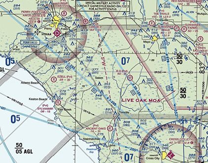
 You’d probably expect military training flights inside military operations areas (MOAs). But don’t forget about military training routes (MTRs) established below 10,000 feet msl for low-altitude, high-speed (in excess of 250 knots) operations. Depicted by gray lines (light brown on en route low-altitude IFR charts), “IR” routes are flown under instrument flight rules and “VR” routes are flown in accordance with visual flight rules.
Take a closer look at the chart: You’ll notice that these routes have numbers—four digits indicate no segment is above 1,500 feet agl; three or fewer specify one or more are above 1,500 agl. MTRs can vary in width from four to 16 miles. Flight direction is indicated by a small arrowhead. Contact flight service to find out about scheduled activity, altitudes, and actual route width before flying within an MTR.
Some MTRs traverse special military activity route (SMAR) corridors defined by gray hashed borders. Ceilings and floors are shown in hundreds of feet msl and agl, respectively. SMARs have a boxed note with a radio frequency to obtain area activity status.
Email [email protected]