FAA Information Effective: Jul 10, 2025
All information is provided from the FAA unless otherwise noted.
(2V6) Yuma Municipal Airport
1 rating | 1 review
Yuma, CO
(970) 848-3878
Overview
Attendance:
Attended
Year-round,Mon-Sat/Daylight
FAA
Elevation:
4,138 ft (Surveyed)
Tower:
No
Airspace:
Unknown
Fees:
None
Timezone:
MDT (UTC-06:00)
Sunrise-Sunset:
5:38 am - 8:17 pm
Evening-Morning Civil Twilight:
8:49 pm
(Today)
(Today)
-
5:08 am
(Tomorrow)
(Tomorrow)
Runway
Satellite
Sectional
FBOs and Other Businesses
Submit New FBO
AOPA Travel Discounts 
FlightBridge is the ultimate all-in-one travel booking platform built for the general aviation community. AOPA Members receive free access to FlightBridge with AOPA discounted rates automatically applied. Members save an average of 30% on hotel bookings! Learn more about FlightBridge HERE.
Local Food/Lodging/Activities
Local Attractions
Local Activities
Restaurants
Hotels and Lodging
Travel Discounts
Pizza Hut
848-5471
2V6
Pizza Hut
Flying Clubs
Submit New Flying Club
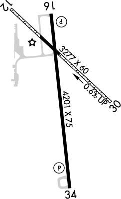
Runway 16/34
Dimensions:
4,201 × 75 ft
(1,280 × 23 m)
(1,280 × 23 m)
Weight Bearing Cap:
Single wheel: 13,000 lbs
Surface:
asphalt, no surface treatment, in excellent condition
Runway Edge Lights:
Medium
Comments:
n/a
| Designator: | 16 | 34 |
| Elevation: | 4,131.5 ft | 4,133.2 ft |
| Heading: | 166° magnetic 173° true | 346° magnetic 353° true |
| Gradient: | 0.04% up | 0.04% down |
| Traffic Pattern: | Not provided. Assume LEFT traffic pattern | Right Pattern |
| Markings: | precision, in Good condition | precision, in Good condition |
| Approach Lighting: |
|
|
| Displaced Threshold: | n/a | n/a |
| ILS/LOC: | n/a | n/a |
| Obstructions: | Tree, 85 ft Left ft of center, 15 ft high, 740 ft from end, 36:1 clearance slope | Other, 124 ft Left ft of center, 13 ft high, 632 ft from end, 33:1 clearance slope |
| Comments: | Intermittent +12 Ft Irrigation Pivot FAA Papi Unusbl Byd 8 Deg Right of Cntrln. FAA | n/a |
Runway 12/30
Dimensions:
3,277 × 60 ft
(999 × 18 m)
(999 × 18 m)
Weight Bearing Cap:
n/a
Surface:
asphalt, gravel, no surface treatment, in good condition
Runway Edge Lights:
n/a
Comments:
Rwy 12/30 Cntr 650 Ft Asph, Rmndr Grvl.
FAA
| Designator: | 12 | 30 |
| Elevation: | 4,137.7 ft | 4,117.9 ft |
| Heading: | 126° magnetic 133° true | 306° magnetic 313° true |
| Gradient: | 0.6% down | 0.6% up |
| Traffic Pattern: | Right Pattern | Left Pattern |
| Markings: | basic, in Good condition | basic, in Good condition |
| Approach Lighting: | n/a | n/a |
| Displaced Threshold: | n/a | n/a |
| ILS/LOC: | n/a | n/a |
| Obstructions: | Road, 16 ft Right ft of center, 18 ft high, 78 ft from end, 4:1 clearance slope | Road, Both-Sides, 13 ft high, 194 ft from end, 14:1 clearance slope |
| Comments: | n/a | n/a |
TFRs
Location: 2V6
Please verify all content below using the FAA TFR Search Site or with a flight briefer.
TFR count: 0
NOTAMs
Location: 2V6
Please verify all content below using the FAA NOTAM Search Site or with a flight briefer.
NOTAM count: 3
| Number: | Start Date: (UTC) | End Date: (UTC) | Condition: |
|---|---|---|---|
| 04/654 | 04/21/2025 1547 | 12/31/2025 2359 | AD AP JET A FUEL NOT AVBL |
| 05/987 | 05/30/2025 2225 | 07/30/2025 2359 | OBST TOWER LGT (ASR 1242632) 400744.10N1024428.60W (1.9NM NW 2V6) 4348.8FT (194.9FT AGL) U/S |
| 4/8468 | 11/25/2024 1542 | IAP YUMA MUNI, YUMA, CO.
RNAV (GPS) RWY 34, ORIG...
LNAV MDA 4640/HAT 507 ALL CATS.
CIRCLING CAT A MDA 4640/… | |
Additional Remarks
Be Alert, Intensive USAF Student Trng In vicinity of Colorado Springs & Pueblo.
Source:
FAA
Federal Aviation Administration
For Clearance Delivery Contact Denver ARTCC at 303-651-4257.
Source:
FAA
Federal Aviation Administration
Rwy 12/30 Soft When Wet.
Source:
FAA
Federal Aviation Administration
Rwy 30 Has 2 Ft Ditch At Thld 0B; 4 Ft Fence 50 Ft Fm Thld 0B.
Source:
FAA
Federal Aviation Administration
Twys Mkd with Blue & Yellow Reflectors.
Source:
FAA
Federal Aviation Administration
Noise Abatement
Instrument Procedures
Data Cycle:
Operations & More Information
Lat/Long:
- 40.10571, -102.71444
- 40° 6′ 20.6″ N, 102° 42′ 52.0″ W
- 40° 6.343′ N, 102° 42.866′ W
ARTCC:
Denver (ZDV)
App/Depart Control Facility:
Unknown
Chart:
NACO: Cheyenne Sectional
FSS:
Denver (DEN)
1-800-WX-BRIEF
1-800-WX-BRIEF
Wind Indicator:
Lighted
Mag Var:
07E (2020)
NOTAM Facility:
Seg Circle:
Yes
Beacon:
Present
Lighting:
Mirl Rwy 16/34 Preset Med Ints Dusk-Dawn. Actvt REIL Rwy 16/34 - CTAF. Pcl not Avbl for PAPI Sys.
FAA
Pattern Altitude:
Light Aircraft 4936 MSL
AM
Special Operations:
Communications Card
| Type: | Frequency / Phone: | Sector / Comments: | Call Sign: |
|---|---|---|---|
| AWOS-3 | 135.375T (970) 848-3007 | ||
| Clearance Delivery Phone | (303) 651-4257 | Denver ARTCC | |
| CTAF | 122.8 | ||
| UNICOM | 122.8 |
Navaids
Services
Fuel:
100LL Low-Lead
AM
Engine Repair:
None
Airframe Repair:
None
Bottled Oxygen:
None
Bulk Oxygen:
None
Customs:
None
Transportation:
None Reported
AM
Activities:
None Reported
Camping On Field:
None Reported
Aircraft & Activity
Webcams
METARs
TAFs
Contact Addresses
Airport Manager
Robert Moore
Yuma, CO 80759
(970) 848-3878 (Office)
Owner
City of Yuma
Yuma, CO 80759
(970) 848-3878 (Office)
Remarks:
City Manager.
FAA
