FAA Information Effective: Jul 10, 2025
All information is provided from the FAA unless otherwise noted.
(KGNV) Gainesville Regional Airport
No ratings | No reviews
Overview
Attendance:
Attended
Year-round, 7 Days a Week,All
FAA
Elevation:
151 ft (Surveyed)
Tower:
Tower Hrs: 0645-2230
FAA
Airspace:
CLASS D SVC 0645-2230; OTHER TIMES CLASS E
FAA
Fees:
Handling, Hangar, Overnight, Other
Click FBO link(s) below for details:
Click FBO link(s) below for details:
FBO Fee Details:
University Air CenterTimezone:
EDT (UTC-04:00)
Sunrise-Sunset:
6:42 am - 8:30 pm
Evening-Morning Civil Twilight:
8:56 pm
(Today)
(Today)
-
6:16 am
(Tomorrow)
(Tomorrow)
Minimum Fuel Prices:
$6.01
100LL (full)
$5.36
100LL (self)
$5.52
Jet-A (full)
$5.62
Jet-A-Premix/Prist (full)
Runway
Satellite
Sectional
FBOs
Submit New FBO
University Air Center
1 rating | 1 review
Services Offered:
Maintenance
Plane Rental
Rotorcraft Rental
Car Rental
Sales
Flight Training
$6.01 | 100LL | full
$5.36 | 100LL | self
$5.52 | Jet-A | full
$5.62 | Jet-A-Premix/Prist | full
Location:
On field: N
Phone:
(352) 335-4681
Freq. Monitored:
UNICOM: 122.95
Fees:
Handling, Hangar, Overnight, Other
Flight Training
Submit New Flight School
University Air Center
1 rating | 1 review
Services Offered:
Maintenance
Plane Rental
Rotorcraft Rental
Car Rental
Sales
Flight Training
$6.01 | 100LL | full
$5.36 | 100LL | self
$5.52 | Jet-A | full
$5.62 | Jet-A-Premix/Prist | full
Location:
On field: N
Phone:
(352) 335-4681
Freq. Monitored:
UNICOM: 122.95
Fees:
Handling, Hangar, Overnight, Other
Other businesses
Submit New Business
AOPA Travel Discounts 
FlightBridge is the ultimate all-in-one travel booking platform built for the general aviation community. AOPA Members receive free access to FlightBridge with AOPA discounted rates automatically applied. Members save an average of 30% on hotel bookings! Learn more about FlightBridge HERE.
Local Food/Lodging/Activities
Local Attractions
Local Activities
Restaurants
Hotels and Lodging
Travel Discounts
(352) 745-7898
(352) 378-7881
(352) 405-1516
(352) 335-7272
(855) 374-8484
GNV
Auto Plus (Gainesville) Raceway
Santa Fe Community College
Gator Skeet & Trap Club
Ironwood Golf Club
Alachua County Fair (Seasonal)
A Perfect Pie
Sonny's BBQ
Heavenly Touched
Satchel's Pizza
Cabs 24HR
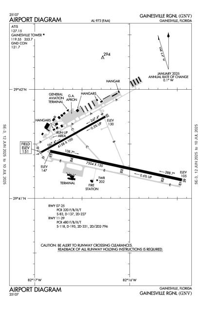
Runway 11/29
Dimensions:
7,504 × 150 ft
(2,287 × 46 m)
(2,287 × 46 m)
Weight Bearing Cap:
Single wheel: 118,000 lbs
Double wheel: 195,000 lbs
Double tandem: 331,000 lbs
Dual double tandem: 796,000 lbs
Double wheel: 195,000 lbs
Double tandem: 331,000 lbs
Dual double tandem: 796,000 lbs
Surface:
asphalt, grooved, in good condition
Runway Edge Lights:
High
Comments:
Pcr Value: 480/F/B/X/T
FAA
Std Grooving Full Length and 130 Ft Wide Center Portion.
FAA
| Designator: | 11 | 29 |
| Elevation: | 147.4 ft | 105.1 ft |
| Heading: | 106° magnetic 102° true | 286° magnetic 282° true |
| Gradient: | 0.56% down | 0.56% up |
| Traffic Pattern: | Not provided. Assume LEFT traffic pattern | Not provided. Assume LEFT traffic pattern |
| Markings: | precision, in Good condition | precision, in Good condition |
| Approach Lighting: |
|
|
| Displaced Threshold: | n/a | n/a |
| ILS/LOC: | n/a | ILS |
| Obstructions: | Trees, 626 ft Right ft of center, 81 ft high, 2,783 ft from end, 31:1 clearance slope | Trees, 458 ft Left ft of center, 68 ft high, 3,535 ft from end, 49:1 clearance slope |
| Comments: | n/a | n/a |
Runway 07/25
Dimensions:
4,158 × 100 ft
(1,267 × 30 m)
(1,267 × 30 m)
Weight Bearing Cap:
Single wheel: 83,000 lbs
Double wheel: 137,000 lbs
Double tandem: 227,000 lbs
Double wheel: 137,000 lbs
Double tandem: 227,000 lbs
Surface:
asphalt, grooved, in fair condition
Runway Edge Lights:
Medium
Comments:
Acr Na.
FAA
Pcr Value: 320/F/B/X/T
FAA
| Designator: | 07 | 25 |
| Elevation: | 151.4 ft | 130.2 ft |
| Heading: | 065° magnetic 061° true | 245° magnetic 241° true |
| Gradient: | 0.51% down | 0.51% up |
| Traffic Pattern: | Left Pattern | Left Pattern |
| Markings: | non-precision, in Good condition | non-precision, in Good condition |
| Approach Lighting: |
|
|
| Displaced Threshold: | n/a | n/a |
| ILS/LOC: | n/a | n/a |
| Obstructions: | Trees, 432 ft Left ft of center, 70 ft high, 2,006 ft from end, 25:1 clearance slope | Trees, 423 ft Left ft of center, 34 ft high, 1,389 ft from end, 34:1 clearance slope |
| Comments: | n/a | n/a |
TFRs
Location: GNV
Please verify all content below using the FAA TFR Search Site or with a flight briefer.
TFR count: 0
NOTAMs
Location: GNV
Please verify all content below using the FAA NOTAM Search Site or with a flight briefer.
NOTAM count: 16 (Partial list shown. Expand to see full list HERE.)
| Number: | Start Date: (UTC) | End Date: (UTC) | Condition: |
|---|---|---|---|
| 06/212 | 06/16/2025 0453 | 10/14/2025 0453 | OBST TOWER LGT (ASR 1045009) 293943.00N0821809.70W (2.4NM SW GNV) 432.1FT (266.1FT AGL) U/S |
| 07/255 | 07/21/2025 1300 | 07/21/2025 1900 | SVC PCL RWY 29 ALS U/S |
| 07/015 | 07/02/2025 1727 | 07/23/2025 2359 | OBST STACK (ASN UNKNOWN) 294531N0822318W (6.9NM NW GNV) 452FT (350FT AGL) NOT LGTD |
| 07/254 | 07/21/2025 1300 | 07/21/2025 1900 | RWY 29 ALS U/S |
| 06/073 | 06/09/2025 1100 | 08/08/2025 2200 | TWY A BTN GA APN SOUTHWEST ACCESS AND TWY A RUNUP PAD FOR RWY 07 CLSD |
| 07/229 | 07/16/2025 1816 | 08/30/2025 1816 | OBST TOWER LGT (ASR 1307233) 293222.13N0820136.87W (15.4NM SE GNV) 366FT (260FT AGL) U/S |
| 06/071 | 06/09/2025 1100 | 08/08/2025 2200 | TWY D BTN APCH END RWY 07 AND TWY A CLSD EXC 1HR PPR 352-262-6691 |
| 07/259 | 07/23/2025 1100 | 07/23/2025 1900 | RWY 07/25 CLSD |
Additional Remarks
Airport Sfc Cond not Mntd Btw 2330 - 0400 Dly.
Source:
FAA
Federal Aviation Administration
Banner Towing Na Exc 72 Hr Prior Permission Required - Amgr.
Source:
FAA
Federal Aviation Administration
For Cd If Una to CTC on FSS Freq, CTC Jacksonville Approach at 904-741-0284.
Source:
FAA
Federal Aviation Administration
Ga Ramp Lmtd to Acft 110,000 Lb or Blw; Others Ppr.
Source:
FAA
Federal Aviation Administration
Portions of Rwy 07/25 & Northeast 1000 Ft of Twy A not Vsb Fm Atct; Blocked by Vortac Bldg.
Source:
FAA
Federal Aviation Administration
Rwy 11-29 Mrkgs on W End are not Std Due to Mrkgs not Fully Removed/Ghosting.
Source:
FAA
Federal Aviation Administration
Twy B Lmtd to 75,000 Lb or Blw; Others Prior Permission Required
Source:
FAA
Federal Aviation Administration
Twy C Lmtd to 120,000 Lb or Blw; Others Prior Permission Required
Source:
FAA
Federal Aviation Administration
When Air Traffic Control Tower Clsd Acft More Than 12500 Lbs CTC FBO for Prkg Instr Prior to Exiting Twy A Due to Ireg Pavement Strengths - 352-335-4681.
Source:
FAA
Federal Aviation Administration
Wildlife on & In vicinity of Arpt.
Source:
FAA
Federal Aviation Administration
Rwy 7/25 not Avbl for Sked Acr Operations with More Than 9 Pax Seats or Unsked Acr At Least 31 Pax Seats.
Source:
FAA
Federal Aviation Administration
Noise Abatement
Instrument Procedures
Data Cycle:
Operations & More Information
Lat/Long:
- 29.69006, -82.27178
- 29° 41′ 24.2″ N, 82° 16′ 18.4″ W
- 29° 41.403′ N, 82° 16.307′ W
ARTCC:
Jacksonville (ZJX)
App/Depart Control Facility:
JAX
Chart:
NACO: Jacksonville Sectional
FSS:
Gainesville (GNV)
1-800-WX-BRIEF
1-800-WX-BRIEF
Wind Indicator:
Lighted
Mag Var:
04W (2005)
NOTAM Facility:
Seg Circle:
Yes
Beacon:
Present
Lighting:
When Air Traffic Control Tower Clsd Actvt MALSR Rwy 29; MIRL Rwy 07/25; HIRL Rwy 11/29 - CTAF.
FAA
Pattern Altitude:
No data provided. Assume 1000 AGL.
Special Operations:
Communications Card
| Type: | Frequency / Phone: | Sector / Comments: | Call Sign: |
|---|---|---|---|
| Approach/Departure | 118.175 | 10000 FT & BLW | Jacksonville |
| ASOS | 127.15T (352) 335-8672 | Gainesville | |
| ATIS | 127.15 | Gainesville | |
| CTAF | 119.55 | Gainesville | |
| Ground Control | 121.7 | Gainesville | |
| Tower | 119.55 | Gainesville | |
| UNICOM | 122.95 | Gainesville |
Navaids
Services
Fuel:
100 Octane, Jet A
AM
Engine Repair:
Major
AM
Airframe Repair:
Major
AM
Bottled Oxygen:
High
AM
Bulk Oxygen:
High
AM
Customs:
None
Transportation:
Courtesy Transportation, Limousine, Shuttle Service, Van
AM
Activities:
Airline Services, Intensive Flight Training
AM
Camping On Field:
None Reported
Aircraft & Activity
Webcams
| Name: | Operated by: | Site: | Facing: |
|---|---|---|---|
| University Air Center Live Stream | University Air Center | FBO | Varies |
METARs
TAFs
Contact Addresses
Airport Manager
Allan Penksa
Gainesville, FL 32609
(352) 373-0249 (Office)
Owner
Gainesville-Alachua County Authority
Gainesville, FL 32609
(352) 373-0249 (Office)
Remarks:
Gainesville-Alachua County Regional Airport Authority
FAA