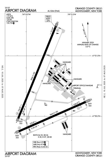
FAA Information Effective: Jul 10, 2025
All information is provided from the FAA unless otherwise noted.
(KMGJ) Orange County Airport
No ratings | 4 reviews
Overview
Attendance:
Attended
May-Oct/Mon-Sat/0700-1900
FAA
Nov--Apr/Mon-Sat/0700-1700
FAA
Year-round,Sun/0830-1630
FAA
Elevation:
370 ft (Surveyed)
Tower:
No
Airspace:
Unknown
Fees:
Landing, Overnight, Parking, Ramp, Other
Click FBO link(s) below for details:
Click FBO link(s) below for details:
FBO Fee Details:
Orange County AirportTimezone:
EDT (UTC-04:00)
Sunrise-Sunset:
5:42 am - 8:26 pm
Evening-Morning Civil Twilight:
8:58 pm
(Today)
(Today)
-
5:11 am
(Tomorrow)
(Tomorrow)
Minimum Fuel Prices:
$6.15
100LL (full)
$5.75
100LL (self)
$6.40
Jet-A-Premix/Prist (full)
$5.99
Jet-A-Premix/Prist (self)
Runway
Satellite
Sectional
FBOs
Submit New FBO
Orange County Airport
No ratings | Be the first to review this business
Services Offered:
Car Rental
$6.15 | 100LL | full
$5.75 | 100LL | self
$6.40 | Jet-A-Premix/Prist | full
$5.99 | Jet-A-Premix/Prist | self
Location:
On field: NE
Phone:
(845) 457-4925
Freq. Monitored:
UNICOM: 122.725
Fees:
Landing, Overnight, Parking, Ramp, Other
Flight Training
Submit New Flight School
Other businesses
Submit New Business
AOPA Travel Discounts 
FlightBridge is the ultimate all-in-one travel booking platform built for the general aviation community. AOPA Members receive free access to FlightBridge with AOPA discounted rates automatically applied. Members save an average of 30% on hotel bookings! Learn more about FlightBridge HERE.
Local Food/Lodging/Activities
Local Attractions
Local Activities
Restaurants
Hotels and Lodging
Travel Discounts
(845) 457-9850
(845) 457-5257
(845) 457-1485
Mike's Deli & Pizza
(845) 457-5411
Syndicated Taxi
(845) 343-7777
900 Route 33 East, Freehold, NJ 07728
(732) 577-0023
MGJ
Winding Hills Golf Club
Scott's Corners Golf Course
Brotherhood Winery
African-American Cemetery (historical site)
88 Charles St Cafe
Copperfields Cafe
Garrison's Tavern
Mike's Deli & Pizza
Syndicated Taxi
Concorde Worldwide Transportation
Flying Clubs
Submit New Flying Club
Runway 04/22
Dimensions:
5,006 × 100 ft
(1,526 × 30 m)
(1,526 × 30 m)
Weight Bearing Cap:
Single wheel: 30,000 lbs
Double wheel: 57,000 lbs
Double tandem: 85,000 lbs
Double wheel: 57,000 lbs
Double tandem: 85,000 lbs
Surface:
asphalt, grooved, in excellent condition
Runway Edge Lights:
High
Comments:
n/a
| Designator: | 04 | 22 |
| Elevation: | 355 ft | 369.9 ft |
| Heading: | 036° magnetic 022° true | 216° magnetic 202° true |
| Gradient: | 0.3% up | 0.3% down |
| Traffic Pattern: | Left Pattern | Right Pattern |
| Markings: | precision, in Good condition | precision, in Good condition |
| Approach Lighting: |
|
|
| Displaced Threshold: | n/a | n/a |
| ILS/LOC: | ILS | n/a |
| Obstructions: | Trees, 489 ft Left ft of center, 54 ft high, 555 ft from end, 6:1 clearance slope | Trees, 523 ft Right ft of center, 65 ft high, 1,272 ft from end, 16:1 clearance slope |
| Comments: | n/a | n/a |
Runway 08/26
Dimensions:
3,664 × 100 ft
(1,117 × 30 m)
(1,117 × 30 m)
Weight Bearing Cap:
Single wheel: 30,000 lbs
Double wheel: 57,000 lbs
Double tandem: 85,000 lbs
Double wheel: 57,000 lbs
Double tandem: 85,000 lbs
Surface:
asphalt, no surface treatment, in good condition
Runway Edge Lights:
Medium
Comments:
n/a
| Designator: | 08 | 26 |
| Elevation: | 352 ft | 364.1 ft |
| Heading: | 080° magnetic 066° true | 260° magnetic 246° true |
| Gradient: | 0.33% up | 0.33% down |
| Traffic Pattern: | Left Pattern | Right Pattern |
| Markings: | non-precision, in Good condition | precision, in Good condition |
| Approach Lighting: |
|
|
| Displaced Threshold: | n/a | 315 ft |
| ILS/LOC: | n/a | n/a |
| Obstructions: | Trees, 28 ft Right ft of center, 69 ft high, 1,788 ft from end, 23:1 clearance slope | Fence, 250 ft Left ft of center, 15 ft high, 200 ft from end |
| Comments: | n/a | Rwy 26 Approach Slope 11:1 Due to 56 Ft Tree 644 Ft Fm Dthr. FAA |
TFRs
Location: MGJ
Please verify all content below using the FAA TFR Search Site or with a flight briefer.
TFR count: 0
NOTAMs
Location: MGJ
Please verify all content below using the FAA NOTAM Search Site or with a flight briefer.
NOTAM count: 5
| Number: | Start Date: (UTC) | End Date: (UTC) | Condition: |
|---|---|---|---|
| 5/1262 | 05/15/2025 1056 | IAP ORANGE COUNTY, MONTGOMERY, NY.
RNAV (GPS) RWY 26, AMDT 1D...
PLANVIEW NOTE: PROCEDURE NA FOR ARRIVALS AT… | |
| 3/1793 | 09/19/2023 1210 | IAP ORANGE COUNTY, MONTGOMERY, NY.
VOR RWY 8, AMDT 9A...
S-8 MDA 1260/HAT 901 ALL CATS.
CIRCLING MDA 1260/HA… | |
| 3/8302 | 12/21/2023 0029 | IAP ORANGE COUNTY, MONTGOMERY, NY.
VOR RWY 8, AMDT 9A...
PROCEDURE NA.
2312210029-2612200029EST | |
| 5/6926 | 07/11/2025 1513 | IAP ORANGE COUNTY, MONTGOMERY, NY.
VOR RWY 8, AMDT 9A...
DME REQUIRED EXCEPT FOR AIRCRAFT EQUIPPED WITH SUIT… | |
| 01/019 | 01/18/2025 2013 | 12/31/2025 2359 | TWY C EDGE LGT U/S |
Additional Remarks
Wind Ind on Rwys 04, 22, 26.
Source:
FAA
Federal Aviation Administration
9 Ft Stabilized Shoulder Each Side of Rwy 8/26.
Source:
FAA
Federal Aviation Administration
Be Aware of Lrg Tbjt Acft In vicinity of Stewart Airport Lctd 7 Nm Ese. 800 Ft Hill 1/2 Mile Northwest of Airport on Downwind/Base Leg for Rwy 22.
Source:
FAA
Federal Aviation Administration
Deer and Birds on and In vicinity of Arpt.
Source:
FAA
Federal Aviation Administration
For Clearance Delivery Contact New York Approach at 516-683-2448 or 123.85
Source:
FAA
Federal Aviation Administration
Fuel Avail. Aft Hrs by Credit Card Self-Svc Ramp.
Source:
FAA
Federal Aviation Administration
Noise Abatement Procedures in Efct; CTC Airport Manager 845-457-4925.
Source:
FAA
Federal Aviation Administration
Rwy 04 Desgnd Calm Wind Rwy.
Source:
FAA
Federal Aviation Administration
Rwy 04-22 Hirls on Photocell Drg Day, on Remote At Ngt.
Source:
FAA
Federal Aviation Administration
Sawrs
Source:
FAA
Federal Aviation Administration
SuperAWOS/Automated UNICOM avbl (AUNICOM) 3 clicks for WX 4 clicks for radio check
Source:
AM
Airport Manager
Huguenot RCO 122.1R 116.1T (NY Radio)
Source:
AM
Airport Manager
Noise Abatement
Instrument Procedures
Operations & More Information
Lat/Long:
- 41.51181, -74.26354
- 41° 30′ 42.5″ N, 74° 15′ 48.7″ W
- 41° 30.709′ N, 74° 15.812′ W
ARTCC:
New York (ZNY)
App/Depart Control Facility:
N90
Chart:
NACO: New York Sectional
FSS:
New York (ISP)
1-800-WX-BRIEF
1-800-WX-BRIEF
Wind Indicator:
Lighted
Mag Var:
14W (2000)
NOTAM Facility:
Seg Circle:
Yes
Beacon:
Present
Lighting:
Pilot Activated Lighting:
- low intensity: 3 clicks in 5 secs
- medium intensity: 5 clicks in 5 secs
- high intensity: 7 clicks in 5 secs
AM
Actvt HIRL Rwy 04/22; MIRL Rwy 08/26; Twy Lgts - CTAF. REIL Rwy 04 & 22; PAPI Rwys 04 & 22; 08 & 26 Opr Consly. Pcl Only Avbl Ss-Sr.
FAA
Pattern Altitude:
TPA: 1030 Ft AGL Singl Eng, 1330 Ft AGL Mult Eng/Turboprop/Jet.
FAA
Special Operations:
Communications Card
| Type: | Frequency / Phone: | Sector / Comments: | Call Sign: |
|---|---|---|---|
| Approach/Departure | 132.75 | New York | |
| ASOS | 119.275T (845) 457-1486 | ||
| Clearance Delivery | 123.85 | New York | |
| Clearance Delivery Phone | (516) 683-2448 | New York Approach | |
| CTAF | 122.725 | ||
| UNICOM | 122.725 |
Navaids
Services
Fuel:
100LL Low-Lead, Jet A
AM
Engine Repair:
Major
AM
Airframe Repair:
Major
AM
Bottled Oxygen:
High/Low
AM
Bulk Oxygen:
High/Low
AM
Customs:
None
Transportation:
Limousine
AM
Activities:
Intensive Flight Training
AM
Camping On Field:
None Reported
Aircraft & Activity
Webcams
METARs
TAFs
Contact Addresses
Airport Manager
Edward Magryta
Montgomery, NY 12549-2402
(845) 457-4925 (Office)
Owner
Orange County
Goshen, NY 10924
(845) 291-4000 (Office)
Airport Reviews
Overall:
No ratings | 4 reviews
Runways and Taxiways:No ratings
Markings and Signage:No ratings
Ground Transportation:No ratings
Sort By:
- 8/5/18Adolfo S.Airport under improvement. No problems. There has not been a restaurant on field for a while. Plenty though in Montgomery 3Km away .
- 10/8/16JOSEPH K.I wish I read the comment about the restaurant being closed sooner. Flew there today to find that its closed. The website for culinary creations is still up and running which led us to believe the same for the business. Joke was on us. I'll call ahea…
- 6/20/14GERARD O.great airport .Easy approach. Cheap gas.Good cafe
- 4/28/13COLIN M.Typo in my below review: I meant NW of the windsock, not NE.


