Forecasters credited with saving lives
Aircraft makers assess tornado damage
In the wake of devastation, there was gratitude. Lives had probably been saved by a team of expert meteorologists stationed, as it turned out, in the path of one of more than 120 tornadoes spawned from a powerful system that tore a swath through the Plains and Midwest beginning on April 14.
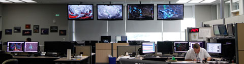
The National Weather Service Storm Prediction Center is the heart of the nation’s severe storm forecasting effort, staffed around the clock and equipped with a dazzling array of digital data feeds. Operations Chief Bill Bunting said the first signs of trouble were spotted a full week in advance, a perfect setup emerging to produce powerful storms—thunder, lightning, baseball-sized hail, and many, many twisters. One of those storms struck Wichita, Kan., tearing the roofs off of buildings where Boeing, Hawker Beechcraft, and Spirit AeroSystems build aircraft parts and systems. According to the Wichita Eagle , it was the worst hit the aviation industry in Wichita has ever taken from a tornado—but no lives were lost.
“THIS IS A LIFE THREATENING SITUATION,” the weather service warned in some locations, language chosen at individual forecasting centers based on briefings from the Storm Prediction Center. “YOU COULD BE KILLED IF NOT UNDERGROUND OR IN A TORNADO SHELTER.”
Kansas Gov. Sam Brownback told The New York Times those warnings proved both timely, and well-worded.
“I really think people took the warnings and they took them very seriously,” Brownback told the Times. “We had more notice on this system than you normally do. You normally are looking at a couple of hours’ notice. Well, this one had almost two days’ notice.”
Bunting said internal discussions had been under way a full week ahead of the developing weather pattern that promised to feed a strong low pressure trough, an extra-tropical cyclone. The rotation of the air mass drew warm, moist air from the Gulf of Mexico into a collision with hot, dry air from the desert and Plains. Strong vertical wind shear added another key ingredient to the recipe for disaster.
“That’s a setup that we frequently see: widespread severe thunderstorms, and, on occasion, long-track violent tornadoes,” Bunting said in an interview at the Storm Prediction Center April 12. On computer screens and hand-drawn charts (that forecasters still use to better analyze the massive flow of data), the trouble was spotted like a distant, oncoming train. “It’s going to interact with some very unstable air, and some very steep lapse rates in the middle part of the atmosphere.”
The center was aided by new radar systems coming on line that enhance the ability of forecasters to assess the precise type of precipitation within storms, such as the shape of raindrops, and wind patterns. Working with Oklahoma University researchers, the National Weather Service team has also refined its computer models in recent years, extending the ability to predict storms in the future. Still, Bunting said, there is no way to predict this kind of weather more than eight days out, and no useful predictions for the still-young tornado season can be offered.
Bunting, in a follow-up interview, said his team briefly took shelter from an oncoming twister that touched down within a few miles of the National Weather Center on the Oklahoma University campus where they work.
“We have shelter in the building,” Bunting said, noting this contingency plan is well-rehearsed, and forecasting and monitoring duties can be transferred to the U.S. Air Force. “They were in a position to help if needed.”
The six lives lost during the outbreak were all claimed by a tornado that struck Woodward, Okla., after local alert sirens malfunctioned—possibly because of a lightning strike.
Storm warning expert Mike Smith joined a chorus heaping praise on the Storm Prediction Center, the National Weather Service, and media outlets for sounding early and effective alarms. There were reports of people taking shelter who might otherwise not have; there also was plenty of luck involved: Most storms struck rural areas rather than densely populated cities.
The Kansas Aviation Museum lost a Vietnam-era Cessna O-2B spotter aircraft (a military version of the 337 Skymaster), one of four aircraft damaged as a twister tore them from their cable tiedowns and tossed them like toys. Museum Director Lon Smith told the Wichita Eagle that while the storm did upwards of $150,000 in damage, “it could have been much, much worse.”
“We dodged a bullet,” Smith told the Eagle. “If you look over at the Spirit, Boeing and the Kansas Air National Guard, our building could have been so quickly made into rubble. We had one broken pane of glass on the building.”
Hawker Beechcraft officials expected minimal interruption to their production, though Spirit and Boeing were still assessing damage Wednesday, and had announced no timetable for resuming production at Spirit AeroSystems.


