The sky can be more crowded than it seems
It seems like there is a never-ending series of issues to consider when you head out to fly your drone. You need to think about the basics like weather, battery health, and where you are going to fly. And airspace, which can be more challenging than you might think.

Drone pilots who have completed their FAA Part 107 certification will have heard the warnings about flying near airports and other limited or prohibited areas. Certificated remote pilots also will have had some familiarization with reading FAA aeronautical charts, a skill that dulls with the lack of use. (Every printed FAA map has a legend on it you can refer to when you forget what something means.)
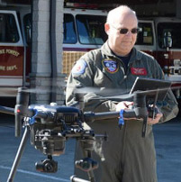
How did I find myself in this situation? I’m a faculty member at the North Carolina Public Safety Drone Academy, and I was asked to teach a class at their location in Montgomery County, North Carolina.
Most of that lovely rural county is cascading woodlands in a remote setting that seems perfectly out of the way and safe to fly.
But many of those out-of-the-way areas are not as far from the beaten path as you may assume. The airspace above can be an alert area like I ran into, a military operations area (MOA), warning area, prohibited area, restricted area, or even a controlled firing area (CFA). These types of special-use airspace are often found in places you might not expect.
MOAs are designated airspace used for military aircraft training and testing. It’s their box in the sky and theirs when they want to use it. And while the floor of some of those MOAs may end thousands of feet up, they can also extend down to the ground. While it may be legal to fly a manned aircraft in an MOA under visual flight rules, that doesn’t mean it’s smart. My rule is if I’m cleared into a MOA on an instrument flight plan, I’ll fly through, but if I’m flying the airplane VFR and an MOA is “hot,” then stay out.
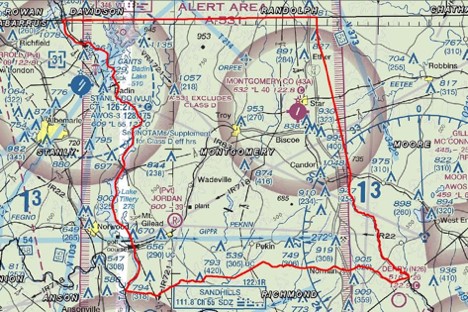
That Montgomery County alert area I mentioned is used for U.S. Army helicopter training from Fort Bragg, so it is no surprise how low to the ground it actually goes.
Apps like B4UFLYand AirMap are designed to give remote pilots some warning about areas to avoid flying in. The FAA says, “B4UFLY is an easy-to-use smartphone app that helps unmanned aircraft operators determine whether there are any restrictions or requirements in effect at the location where they want to fly.”
But these apps do not always depict special-use airspace you need to be aware of.
As an aircraft pilot I’m fortunate to have a number of aviation resources right on my smartphone. I love the ForeFlight app, and so in a couple of taps I can see the details on airspace issues over Montgomery County. Turns out it is Alert Area A-531, and ForeFlight tells me it extends down to 200 feet agl. The sky above my operations can be impacted when that alert area is in use. The last thing a training Army helicopter pilot needs is me flying in their practice area when they are using it.
Area A-531 is listed as being active between 200 feet and 1,500 feet agl, and intermittently between 6 a.m. and midnight, Monday through Friday, and occasionally on weekends. Even if you don’t have an app like ForeFlight, you can see a warning for that area on a printed FAA sectional chart. The sectional map chart notes: “CAUTION: Extensive Military Helicopter Training 200’ AGL to 1500’ AGL.” According to the FAA, “Only those activities that do not pose a hazard to other aircraft may be conducted in an alert area.”
The easiest way to check on many active operational special-use areas is to visit the FAA SUA website.
The FAA website will show you which special-use airspace areas are active at the moment. Unfortunately it does not give you details on all special-use airspace areas that may be in use, like the alert area I mentioned. But knowing that A-531 only extends down to 200 feet agl, at least I know I can safely operate under that altitude, and not fly higher unless I can positively confirm the alert area is “cold” (not in use).
There are a few free online sites where you can see special-use airspace in the area you plan to fly. You can look at at FAA.gov, vfrmap.com, or skyvector.com
Here is the bottom line: While your UAS flight may not be strictly prohibited, drone pilots should be certain they are not going to interfere with operations in those areas. If they are active, or “hot,” make sure the flight doesn’t end in an airspace violation, or worse.