‘Extremely active’ storm season makes waves with Hurricane Laura
For storm-savvy pilots, preparation is everything
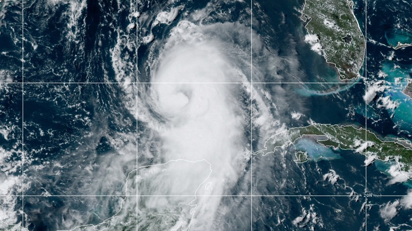
The powerful storm that rapidly intensified from a tropical storm to Category 4 Hurricane Laura on August 26 made landfall along the Louisiana and Texas coast early on August 27 and began to weaken as it moved inland on a track toward Arkansas, the mid-Mississippi Valley, and the mid-Atlantic states.
For aircraft owners, the rare threat of a one-two punch from the potentially catastrophic Hurricane Laura closely following diminishing Tropical Storm Marco highlighted the importance of having plans ready to go for escaping a storm-targeted area or sheltering your aircraft in place and hunkering down. In 2020, storm prep attained a higher-than-usual profile when government weather forecasters said in early August that conditions were “primed” to produce an “extremely active” season of storm development in the Atlantic Ocean.
Evacuations were ordered from coastal areas ahead of the storm with the National Hurricane Center warning of an "unsurvivable storm surge with large and destructive waves will cause catastrophic damage from Sea Rim State Park, Texas, to Intracoastal City, Louisiana, including Calcasieu and Sabine Lakes,” and a storm surge expected to reach up to 30 miles inland in southwestern Louisiana and southeastern Texas.
The National Hurricane Center said Laura’s maximum sustained winds were near 100 mph with higher gusts—making it a Category 2 hurricane on the Saffir-Simpson Hurricane Wind Scale. Hurricane-force winds extended to 60 miles from the center, with tropical-storm-force winds reaching to 175 miles. With the storm rapidly weakening, Laura’s track was expected to bring heavy rains to the mid-Mississippi Valley, portions of the Tennessee and Lower Ohio Valley, the central Appalachians, and the mid-Atlantic states with the risk of “flash and urban flooding and rapid rises on small streams,” the agency said in an August 27 morning bulletin.
Tips for relocating your aircraft in advance of storms
Indications of Laura's rapid intensification had become evident by August 25 when winds had already surpassed 75 mph over the warm waters of the Gulf of Mexico. Sustained winds reached 115 mph by the next day. Galveston, Texas—which sits on an island in the Gulf—was under a mandatory evacuation order, as were other coastal communities in the two states. Houston was also battening down.
AOPA hears from many members seeking advice at times like this, and offers an online “Hurricanes” resource page providing key information about how to make and carry out your storm-survival strategy safely.
For pilots, planning should include closely following predicted storm tracks and selecting suitable and available evacuation airports—perhaps coordinating your plans with other pilots who can move your aircraft to safety if you are not available at “go” time. But don’t forego setting up a local backup plan in case a safe evacuation cannot be made.
Weathering the storm
Planning to stay put—and by a stroke of good luck you were able to buy your way into a hangar?
Congratulations—with a caveat: As our “Hurricanes” page advises, it pays to look closely at the hangar building’s construction, because a poorly built structure could cause more damage to your aircraft if it collapses than your aircraft would have sustained if it were properly tied down.
If you must tie down the aircraft outside, consider applying a similarly strategic approach that takes into account some key features of the tiedown location (an ideal site lets you park facing upwind in an area free of objects that could be blown toward the aircraft). See the “Hurricanes” page for other strategic tiedown tips.
Storms or no, sloppily secured aircraft are an all-too-common sight around airports, so how’s your tiedown technique? If your work is “knot” any better than slipshod, here’s a resource that can show you the ropes.
Some aircraft insurance may reimburse storm-related evacuation or storage expenses, so check your policy and give it a glance for coverage of storm-related losses.
They who hesitate
A key point to grasp about planning is that when the time comes to act, you may feel that your information is still incomplete. Don’t let that idea bring on analysis paralysis.
If evacuation is your decision, it may also be wise to prepare for a long stay at your safe haven. When Hurricane Florence hammered North Carolina on September 14, 2018, pilot Mark Finkelstein flew his single-engine Columbia 400 to safety in Kentucky, where he waited—and waited—for high waters from the lingering storm to recede.
“Once I got there, it was agonizing to see how long the storm lingered over my area. It was literally moving at 2 MPH at one point and took days to move off,” he recalled.


