Bryant helo descended rapidly into terrain
Investigators probing the January 26 helicopter crash that killed basketball legend Kobe Bryant, his daughter Gianna, and seven others said there is no evidence that terrain awareness technology was available to the pilot as he attempted to negotiate rising terrain in poor visibility.
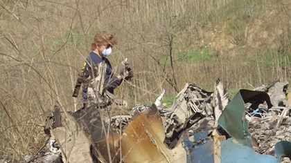
The NTSB dispatched a team to Los Angeles and the FAA established a temporary flight restriction over the scene within hours of the fatal accident that triggered mourning far beyond the world of professional basketball players and fans. Images of the burning wreckage of the Sikorsky S–76B operated under Part 135 by Island Express Holding and scattered on a hillside were broadcast live on cable news outlets that devoted days of programming to the loss of one of the National Basketball Association’s greatest players of all time. Bryant retired four years ago as one of the league’s top scorers, and was expected to be inducted into the Hall of Fame this year, his first year of eligibility. He was traveling with his 13-year-old daughter and others from John Wayne Airport in Orange County to Bryant’s basketball academy in Thousand Oaks, California, according to multiple media reports.
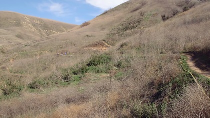
Visibility was limited by clouds and fog at the time of the ill-fated flight, and the pilot may have lost sight of the highways and other visual references he was attempting to follow to his destination.
“We know that the helicopter was at 2,300 feet when it lost communications with air traffic control,” Homendy said. “The descent rate for the helicopter was over 2,000 feet a minute, so we know that this was a high-energy impact crash, and the helicopter was in a descending left bank.”
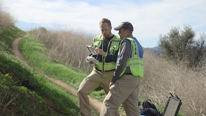
Homendy said investigators had concluded the recovery of the wreckage having found all critical parts of the helicopter in the impact area, so they believe the helicopter was intact when it hit the ground. Investigators confirmed the helicopter was not equipped with terrain awareness and warning system capability. Homendy noted that the board had recommended mandating such equipment for commercial helicopters following previous accidents, but the FAA had not implemented that recommendation. The absence of a cockpit voice recorder and flight data recorder, also recommended by the NTSB following previous accidents, was also noted.
Aviation International News analyzed publicly available radar data and recorded air traffic control audio to develop a detailed chronology of the ill-fated flight. Low ceilings and fog prevailed at the time of the accident, 9:47 a.m. Pacific Standard Time. The flight appeared to have wound its way through rising terrain in limited visibility. The final moments of recorded radar and ADS-B data indicate rapid changes in speed and altitude before the helicopter impacted terrain. There was no distress call.
Chuck Street, executive director of the Los Angeles Area Helicopter Operators Association (of which Island Express is a member) praised the company’s overall commitment to safety, as well as pilot Ara Zobayan, who was among the nine people killed in the accident, in an interview with the Los Angeles Times.
“He took what he did seriously,” Street said. “The words that come up in my mind when I think of him: professional and cheerful.”
Various media outlets noted that poor visibility conditions were widespread at the time of the accident, grounding police helicopter operations in Los Angeles County and elsewhere, including Fresno County. The New York Times chartered a helicopter to retrace the path of the ill-fated flight and glean additional insight on the pilot's struggle with deteriorating visibility.
Homendy said Zobayan had logged 8,200 hours by the time he applied for his most recent second class medical certificate in July 2019, and that included 1,250 hours in the S–76. While Zobayan was known to have owned an iPad with ForeFlight, investigators were still unsure whether the device found in the wreckage was his.
AOPA Air Safety Institute Executive Director Richard McSpadden fielded several calls from reporters following the crash, and took pains to point out that helicopters log about 3 million flight hours a year in the United States, and that tragedies like the loss of Bryant, his pilot, and fellow passengers can create a false perception about the risks involved in aviation. The Los Angeles Times, after its own analysis of safety data, noted that the Sikorsky S–76 has an enviable safety record overall, with just 0.2 fatal crashes per 100,000 flight hours from 2006 to 2016.
McSpadden said that it is always premature to draw conclusions about any accident, particularly including the safety implications, until the details of the investigation are known. “I’ve been reinforcing that message on several interviews this morning,” McSpadden said.
Likewise, the Helicopter Association International and Sikorsky, a Lockheed Martin company, expressed similar sentiments in the immediate aftermath.
“Helicopter Association International expresses our deepest sympathies to the families, friends, and coworkers of those lost in today’s crash. HAI’s official policy is to refrain from commenting on any accident until authorities complete their investigation,” the association said in a statement.
Sikorsky also issued a statement:
“We extend our sincerest condolences to all those affected by today’s Sikorsky S–76B accident in Calabasas, California. We have been in contact with the NTSB and stand ready to provide assistance and support to the investigative authorities and our customer. Safety is our top priority; if there are any actionable findings from the investigation, we will inform our S–76 customers.”


