Mapping the tallest volcano in North America
When our partners in Mexico were awarded the contract to map the entire state of Puebla, in Mexico, I celebrated with them, but little did I suspect it would become one of my most interesting and challenging flights.

A few months later, when the contract was underway, I received a call from the chief pilot in Mexico. The Piper PA–23 Aztec they were using for the mission was having a hard time reaching the necessary altitude to cover the most prominent feature of the area: Pico de Orizaba, the tallest volcano in North America, reaching more than 18,000 feet above sea level and spanning two Mexican states, Puebla and Veracruz.
I looked at my calendar and immediately sent a text to the best photogrammetry pilot I know, my good friend Jean Gabriel (Jeannot) Ducournau, about his availability. Ducournau and I have been flying photogrammetry missions since the early 1990s when we flew mining concessions in the Venezuelan Amazon jungle.
There was a cold front moving through the Puebla region, so the prospects for good weather on the mountain, by the time of our arrival, were excellent. Ducournau immediately replied he was available, which was rare, so I committed to the flight.
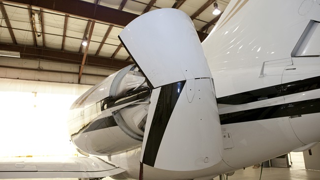
The next day Ducournau and I caught a commercial flight from Miami to Houston, and in 48 hours we took off from our base at Conroe-North Houston Regional Airport to Ingeniero Juan Guillermo Villasana Airport in a Citation II the company had bought from U.S. Customs and Border Protection in a government auction. Because of the sensitive nature of the equipment on board, CBP had removed all navigational equipment, radar, and hundreds of pounds of secret equipment, so we upgraded the avionics suite to the dual Garmin 750 and installed five high-resolution PhaseOne Industrial cameras for our vertical cartographic photography. These cameras produce a high-definition picture of 100 megapixels every two seconds.
These aircraft, even if they are not pretty in the way that executive jets are, are magnificent photogrammetry platforms and can fly for weeks on end without a squawk, which is just what you need when you are in the middle of nowhere and require a trusted airplane. With the new avionics and the lack of any extra seats or luxury items, the jet is light and climbs comfortably at 2,000 fpm with four people on board and 5,000 pounds of fuel.
The city of Pachuca is northeast of Mexico City, and even though its airport is close enough to be an important executive hub for the capital, it’s only used for VFR operations and surrounded by mountains.
We landed in Pachuca midafternoon and met our photography crew; Noé Pimentel, our camera operator; and Julio Mendoza, computer whiz and navigator.
The next morning was glorious! Crisp, cold, and not a cloud in a thousand miles around Pachuca, so we took off at 8 a.m., and as soon as we reached a cruising altitude of 18,000 feet, we knew it was going to be a long day.
We headed straight to the volcano and while I handled the aircraft, Ducournau negotiated with Mexico Center, the busiest airspace in the country. We were cleared to the area with altitudes varying from 14,000 feet at the base of the massive cone to 22,500 feet for our last line.
We had about three hours of usable fuel, so we alerted our navigator and camera operator to be ready while we headed straight for our first line at 14,500 feet and about 2 miles horizontally from the side of the mountain.
Immediately we noticed that winds were strong at the top of the volcano and puffs of snow were swirling around the caldera.
“We have to be extra careful with the crab,” Ducournau said with a hint of worry in his voice.
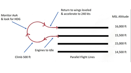
We entered the first line perfectly aligned with the side of the mountain, with a heading of 340 degrees and with a respectable crab to the right, but within parameters. The air was clear with moderate turbulence. The line was exactly 10 miles long and was flown at 240 knots groundspeed. As soon as we completed the line, we executed a ”light bulb” maneuver while climbing 500 feet to our next line, which was flown at a reverse course of 160 degrees and 15,000 feet.
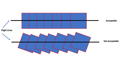
In photogrammetry, the parallel lines that need to be flown are located relatively close to each other, so normally, photogrammetry pilots fly the initial line and then skip two or three lines as they turn 180 degrees in order to avoid the light bulb maneuver. In the case of the Orizaba, the steep nature of the terrain and rapidly changing lighting conditions forced us to fly this way so the photographs would have a uniformity in terms of shadows and coloring.
The light bulb maneuver
This way of turning around in aerial photography flying takes the aircraft away from the adjacent line in order to create enough horizontal distance and then back to the reverse course with enough time to stabilize the roll before entering the line. Over the years, Ducournau and I had developed a technique that involved bringing the engines to idle as soon as the camera was turned off and then, as we climbed the 500 feet necessary for the next altitude, we turned away from our finished line and carefully returned to the desired course just in time to turn on the cameras with wings leveled. It required coordination and a close eye on the angle of attack while climbing and returning to the desired heading, but it was a sure way to save precious minutes, and fuel, between lines.
From time to time, Ducournau reached out to Mexico Center to report our position and intentions, and they were very cooperative as long as we stayed within the mountain borders.
When we reached the previous-to-last line, we were flying at 22,000 feet and 1 mile from the open caldera. The winds had subsided considerably at this altitude, so I took out my smartphone and filmed 20 seconds of the dramatic view from my left seat.
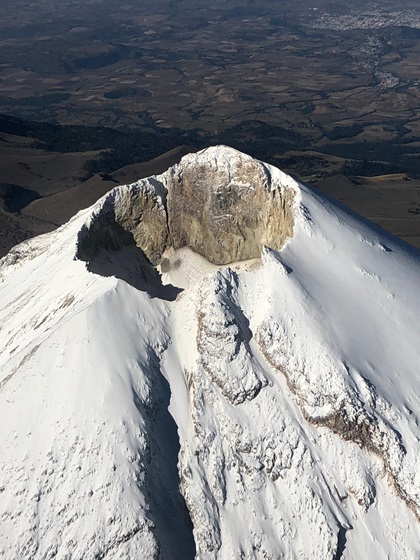
Then came the last line, directly over the volcano and at an altitude of 22,500 feet to get a spectacular vertical image of the dormant, but not extinct, volcano.
“Done!” said Pimentel, the camera operator, as soon as the camera took the last photo of the line.
“Can we see the photo of the caldera?” I asked while Ducournau negotiated our return to Pachuca with Mexico Center.
Pimentel approached the cockpit with his computer and showed us an image that few pilots will ever see: a vertical image of a volcano a few seconds after the fact. The mission was a success.
Having the right aerial platform for the job makes all the difference in aviation, and in this case, the Citation II proved its worth plus interest.
Juan Plaza
Related Articles