You can't out-climb mountains, pilot learns the hard way
(LAX03LA214)
You can't out-climb mountains, pilot learns the hard way |
 Flying in the mountains can be an extremely rewarding experience, but with it comes potential dangers. The pilot of a Cessna 152 learned this the hard way when she hit trees and a pole while attempting to turn away from rising terrain in the Spring Mountains west of Las Vegas. Although the pilot received only minor injuries, the airplane was substantially damaged.
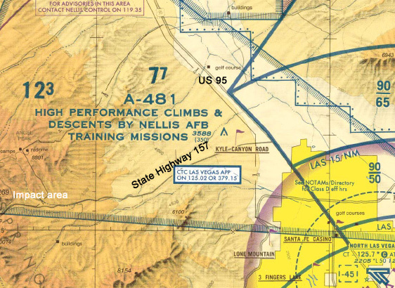
The pilot filed a flight plan from North Las Vegas Airport (VGT) to Reno, Nevada, via Beatty, Nevada. After departing North Las Vegas, the pilot was handed off to Nellis Departure. About 20 miles northwest of North Las Vegas, the pilot requested a turn in order to gain additional altitude. While turning, the pilot was asked by the Nellis controller if she saw the highway below. She responded "yes," and was told that many pilots follow the highway through the pass because the road leads to Beatty. Checking the airplane's approximate position against the Las Vegas Sectional, there were two roads in her vicinity — U.S. Highway 95, which heads to Beatty, and Nevada State Highway 157, which heads into the Spring Mountain range. After following the wrong road [Highway 157] for several minutes, the controller told the pilot that she had gone below radar coverage.
As the pilot followed the road she thought was Highway 95, she initiated a climb to 8,200 feet due to continually rising terrain. In an effort to avoid a stall, the pilot made a conscious effort to "trade altitude for airspeed" and rapidly climb. Mountains surrounded the airplane, and the pilot was unable to maintain altitude. As the airspeed dropped, the pilot extended 10 degrees of flaps to avoid a stall. The pilot then turned left to exit the valley. In the turn, and as the aircraft hit the terrain, the left wing clipped a telephone pole and trees came through the windshield.
Performance calculations indicated that the terrain along her route of flight rose significantly, obviously in excess of the climb capability of the Cessna 152. The density altitude at the 8,000-foot msl level was 11,660 feet. Highway 95 runs in a northwesterly direction through a wide and safe 4,000-foot valley between mountain ranges while Highway 157 (the highway this pilot was following) runs in a westerly direction into the Spring Mountains with peaks well over 10,000 feet.
The NTSB determined the cause of this accident to be the pilot's inadequate in-flight planning and selection of the wrong route of flight, which led the airplane toward rising terrain in excess of the performance capability of the aircraft. Also, a causal factor was the pilot's delayed decision to divert her route of flight.
Although ATC offered the pilot a safe route through the mountains, the advice could have been stated more clearly. The pilot should have recognized that there was more than one road in the area (they are clearly depicted on the chart) and asked for additional clarification before blindly following the advice of ATC.
When flying in the mountains, it is important to understand both the performance limits of your aircraft, as well as the terrain you will be flying in. Also, it's good practice to talk to local pilots before you depart in order to learn some of the local routes and landmarks. For more information about mountain flying, take the AOPA Air Safety Institute's newest online course, Mountain Flying.
Accident reports can be found in ASI's accident database.