FAA Information Effective: May 15, 2025
All information is provided from the FAA unless otherwise noted.
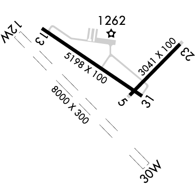
(KAUW) Wausau Downtown Airport
No ratings | No reviews
Overview
Attendance:
Attended
Year-round, 7 Days a Week,0800-1700
FAA
Elevation:
1,201 ft (Surveyed)
Tower:
No
Airspace:
Unknown
Fees:
Landing, Ramp, Tie Down, Other
Click FBO link(s) below for details:
Click FBO link(s) below for details:
FBO Fee Details:
Wausau Flying Service, Inc.Timezone:
CDT (UTC-05:00)
Sunrise-Sunset:
5:15 am - 8:40 pm
Evening-Morning Civil Twilight:
9:17 pm
(Today)
(Today)
-
4:38 am
(Tomorrow)
(Tomorrow)
Minimum Fuel Prices:
$5.70
100LL (full)
$5.70
100LL (self)
$5.15
Jet-A-Premix/Prist (full)
$4.10
MOGAS (self)
Runway
Satellite
Sectional
FBOs
Submit New FBO
Wausau Flying Service, Inc.
No ratings | Be the first to review this business
Services Offered:
Plane Rental
Car Rental
Flight Training
$5.70 | 100LL | full
$5.70 | 100LL | self
$5.15 | Jet-A-Premix/Prist | full
$4.10 | MOGAS | self
Location:
On field: CTR
Phone:
(715) 845-3400
Freq. Monitored:
UNICOM: 122.7
Fees:
Landing, Ramp, Tie Down, Other
Flight Training
Submit New Flight School
Wausau Flying Service, Inc.
No ratings | Be the first to review this business
Services Offered:
Plane Rental
Car Rental
Flight Training
$5.70 | 100LL | full
$5.70 | 100LL | self
$5.15 | Jet-A-Premix/Prist | full
$4.10 | MOGAS | self
Location:
On field: CTR
Phone:
(715) 845-3400
Freq. Monitored:
UNICOM: 122.7
Fees:
Landing, Ramp, Tie Down, Other
Other businesses
Submit New Business
AOPA Travel Discounts 
FlightBridge is the ultimate all-in-one travel booking platform built for the general aviation community. AOPA Members receive free access to FlightBridge with AOPA discounted rates automatically applied. Members save an average of 30% on hotel bookings! Learn more about FlightBridge HERE.
Local Food/Lodging/Activities
Local Attractions
Local Activities
Restaurants
Hotels and Lodging
Travel Discounts
Rib Mountain Ski
Leigh Yawkey Woodson Art Museum
Grand Theatre
Wausau Center Mall
Applebee's
(715) 848-1110
The Mint
(715) 845-5879
AUW
Rib Mountain Ski
Leigh Yawkey Woodson Art Museum
Grand Theatre
Wausau Center Mall
Applebee's
The Mint
Flying Clubs
Submit New Flying Club
Waterway 12W/30W
Dimensions:
8,000 × 300 ft
(2,438 × 91 m)
(2,438 × 91 m)
Weight Bearing Cap:
n/a
Surface:
water
Runway Edge Lights:
n/a
Comments:
n/a
| Designator: | 12W | 30W |
| Elevation: | 1,166 ft | 1,166 ft |
| Heading: | n/a | n/a |
| Traffic Pattern: | Not provided. Assume LEFT traffic pattern | Not provided. Assume LEFT traffic pattern |
| Markings: | none, in Good condition | none, in Good condition |
| Obstructions: | n/a | n/a |
| Comments: | n/a | n/a |
Runway 13/31
Dimensions:
5,200 × 100 ft
(1,585 × 30 m)
(1,585 × 30 m)
Weight Bearing Cap:
Single wheel: 45,000 lbs
Double wheel: 80,000 lbs
Double tandem: 140,000 lbs
Double wheel: 80,000 lbs
Double tandem: 140,000 lbs
Surface:
asphalt, no surface treatment, in fair condition
Runway Edge Lights:
Medium
Comments:
n/a
| Designator: | 13 | 31 |
| Elevation: | 1,192.1 ft | 1,190.1 ft |
| Heading: | 127° magnetic 124° true | 307° magnetic 304° true |
| Gradient: | 0.04% down | 0.04% up |
| Traffic Pattern: | Left Pattern | Left Pattern |
| Markings: | non-precision, in Fair condition | non-precision, in Fair condition |
| Approach Lighting: |
|
|
| Displaced Threshold: | n/a | n/a |
| ILS/LOC: | n/a | n/a |
| Obstructions: | Trees, 410 ft Left ft of center, 34 ft high, 250 ft from end, 1:1 clearance slope | Trees, 375 ft Left ft of center, 38 ft high, 225 ft from end |
| Comments: | 40 Ft Trees 0-200 Ft Fm Thr 300 Ft R & 450 Ft L. FAA | 30 Ft Trees 150 Ft Fm Thr 425 Ft L. FAA |
Runway 05/23
Dimensions:
3,041 × 100 ft
(927 × 30 m)
(927 × 30 m)
Weight Bearing Cap:
Single wheel: 32,000 lbs
Double wheel: 55,000 lbs
Double tandem: 95,000 lbs
Double wheel: 55,000 lbs
Double tandem: 95,000 lbs
Surface:
asphalt, no surface treatment, in fair condition
Runway Edge Lights:
Medium
Comments:
n/a
| Designator: | 05 | 23 |
| Elevation: | 1,190.4 ft | 1,201 ft |
| Heading: | 047° magnetic 044° true | 227° magnetic 224° true |
| Gradient: | 0.35% up | 0.35% down |
| Traffic Pattern: | Left Pattern | Left Pattern |
| Markings: | basic, in Fair condition | basic, in Fair condition |
| Approach Lighting: | n/a | n/a |
| Displaced Threshold: | n/a | n/a |
| ILS/LOC: | n/a | n/a |
| Obstructions: | n/a | n/a |
| Comments: | n/a | n/a |
TFRs
Location: AUW
Please verify all content below using the FAA TFR Search Site or with a flight briefer.
TFR count: 0
NOTAMs
Location: AUW
Please verify all content below using the FAA NOTAM Search Site or with a flight briefer.
NOTAM count: 6
| Number: | Start Date: (UTC) | End Date: (UTC) | Condition: |
|---|---|---|---|
| 05/020 | 06/02/2025 1200 | 06/13/2025 2200 | TWY A BTN MAIN APN AND TXL NUMBER 3 CLSD |
| 05/006 | 05/12/2025 2338 | 06/26/2025 2337 | OBST TOWER LGT (ASN 2021-AGL-35190-OE) 445315N0895039W (9.5NM WSW AUW) 1721FT (304FT AGL) U/S |
| 05/017 | 06/03/2025 0500 | 06/03/2025 1000 | COM REMOTE COM OUTLET 122.4 U/S |
| 06/002 | 06/04/2025 0500 | 06/04/2025 1100 | COM LOCAL AP ADVISORY SERVICE 122.4 U/S |
| 05/013 | 05/19/2025 1536 | 06/20/2025 2300 | APRON MAIN APN WIP CONST LGTD AND BARRICADED |
| 05/016 | 05/27/2025 0442 | 07/11/2025 0441 | OBST TOWER LGT (ASR 1036068) 450333.00N0892610.00W (11.4NM NE AUW) 2478.7FT (1013.8FT AGL) U/S |
Additional Remarks
For Cd If Una to CTC on FSS Freq, CTC Minneapolis ARTCC at 651-463-5588.
Source:
FAA
Federal Aviation Administration
Noise Abatement
| Runway: | Applies to: | Approach/Departure: | Text: |
|---|---|---|---|
| All | All Aircraft | Both | Run-up on FBO ramp for dep on ry 12; perform run-up for ry's 30, 04, & 22 prior to crossing ry 04-22 |
| All | All Aircraft | Both | Avoid low level fly-bys & repeated takeoff & ldg ops on Lake Wausau |
Instrument Procedures
Data Cycle:
Operations & More Information
Lat/Long:
- 44.92628, -89.62700
- 44° 55′ 34.6″ N, 89° 37′ 37.2″ W
- 44° 55.577′ N, 89° 37.620′ W
ARTCC:
Minneapolis (ZMP)
App/Depart Control Facility:
Unknown
Chart:
NACO: Green Bay Sectional
FSS:
Green Bay (GRB)
1-800-WX-BRIEF
1-800-WX-BRIEF
Wind Indicator:
Lighted
Mag Var:
03W (2015)
NOTAM Facility:
Seg Circle:
Yes
Beacon:
Present
Lighting:
Pilot Activated Lighting:
- low intensity: 3 clicks in 3 secs
- medium intensity: 5 clicks in 5 secs
- high intensity: 7 clicks in 7 secs
AM
Mirl Rwy 13/31 Preset to Low; to Incr Intst and Actvt REILs Rwy 13 & 31; PAPI Rwy 13 & 31; MIRL Rwy 5/23 - CTAF.
FAA
Pattern Altitude:
Light Aircraft 2201 MSL
AM
Special Operations:
Seaplane Ops
FAA
Communications Card
| Type: | Frequency / Phone: | Sector / Comments: | Call Sign: |
|---|---|---|---|
| ASOS | 125.925T (715) 843-7215 | ||
| CTAF | 122.7 | ||
| UNICOM | 122.7 |
Navaids
Services
Fuel:
100LL Low-Lead, MOGAS
AM
Engine Repair:
Major
AM
Airframe Repair:
Major
AM
Bottled Oxygen:
None
Bulk Oxygen:
None
Customs:
None
Transportation:
Courtesy Transportation, Limousine, Public Transportation, Van
AM
Activities:
Intensive Flight Training
AM
Camping On Field:
None Reported
Aircraft & Activity
Webcams
METARs
METARs from this airport:
METARs from nearby reporting stations:
TAFs
TAFs from nearby airports:
Contact Addresses
Airport Manager
John P Chmiel
Wausau, WI 54401
(715) 845-3400 (Office)
Owner
City of Wausau
Wausau, WI 54403
(715) 261-6740 (Office)
Airport Reviews
Nearby Events
- aopa rusty pilotsAOPA Rusty Pilots Seminar at Moore County Airport (SOP)08/02/2025Location: Sandhills Fliers / Sovereign Aerospace
 Description:Life may have gotten in the way, but the dream of flight can be yours again. Returning to the skies is not as difficult as most rusty pilots think.
 - airshow
 Description:Sky High Aerospace Expo and Fly-In