FAA Information Effective: May 15, 2025
All information is provided from the FAA unless otherwise noted.
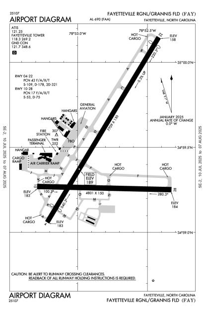
(KFAY) Fayetteville Regional/Grannis Field
No ratings | 3 reviews
Overview
Attendance:
Attended
Year-round, 7 Days a Week,0600-0000
FAA
Elevation:
189 ft (Surveyed)
Tower:
Primary Approach Control Hrs: 24
FAA
Primary Depart. Control Hrs: 24
FAA
Tower Hrs: 24
FAA
Airspace:
C
Fees:
Handling, Overnight, Other
Click FBO link(s) below for details:
Click FBO link(s) below for details:
FBO Fee Details:
Signature Flight SupportTimezone:
EDT (UTC-04:00)
Sunrise-Sunset:
6:04 am - 8:25 pm
Evening-Morning Civil Twilight:
8:54 pm
(Today)
(Today)
-
5:34 am
(Tomorrow)
(Tomorrow)
Minimum Fuel Prices:
$7.35
100LL (full)
$6.38
Jet-A (full)
Runway
Satellite
Sectional
FBOs
Submit New FBO
Signature Flight Support
No ratings | Be the first to review this business
Services Offered:
Car Rental
$7.35 | 100LL | full
$6.38 | Jet-A | full
Location:
On field: CTR
Phone:
(910) 321-7540
Freq. Monitored:
UNICOM: 122.95
Fees:
Handling, Overnight, Other
Flight Training
Submit New Flight School
Other businesses
Submit New Business
AOPA Travel Discounts 
FlightBridge is the ultimate all-in-one travel booking platform built for the general aviation community. AOPA Members receive free access to FlightBridge with AOPA discounted rates automatically applied. Members save an average of 30% on hotel bookings! Learn more about FlightBridge HERE.
Local Food/Lodging/Activities
Local Attractions
Local Activities
Restaurants
Hotels and Lodging
Travel Discounts
Flying Clubs
Submit New Flying Club
Runway 04/22
Dimensions:
7,709 × 150 ft
(2,350 × 46 m)
(2,350 × 46 m)
Weight Bearing Cap:
Single wheel: 109,000 lbs
Double wheel: 178,000 lbs
Double tandem: 321,000 lbs
Double wheel: 178,000 lbs
Double tandem: 321,000 lbs
Surface:
asphalt, grooved, in good condition
Runway Edge Lights:
High
Comments:
Rwy 04/22 Non-Std Safety Area Due to Terrain Features on East Side of Rwy, Btwn Twys B and D.
FAA
| Designator: | 04 | 22 |
| Elevation: | 183.1 ft | 157.7 ft |
| Heading: | 038° magnetic 031° true | 218° magnetic 211° true |
| Gradient: | 0.33% down | 0.33% up |
| Traffic Pattern: | Left Pattern | Left Pattern |
| Markings: | precision, in Good condition | precision, in Good condition |
| Approach Lighting: |
|
|
| Displaced Threshold: | 598 ft | 303 ft |
| ILS/LOC: | ILS/DME | n/a |
| Obstructions: | n/a | n/a |
| Comments: | n/a | n/a |
Runway 10/28
Dimensions:
4,801 × 150 ft
(1,463 × 46 m)
(1,463 × 46 m)
Weight Bearing Cap:
Single wheel: 53,000 lbs
Double wheel: 75,000 lbs
Double wheel: 75,000 lbs
Surface:
asphalt, no surface treatment, in excellent condition
Runway Edge Lights:
Medium
Comments:
n/a
| Designator: | 10 | 28 |
| Elevation: | 182.9 ft | 183.8 ft |
| Heading: | 098° magnetic 091° true | 278° magnetic 271° true |
| Gradient: | 0.02% up | 0.02% down |
| Traffic Pattern: | Left Pattern | Left Pattern |
| Markings: | non-precision, in Good condition | non-precision, in Good condition |
| Approach Lighting: |
|
|
| Displaced Threshold: | n/a | n/a |
| ILS/LOC: | n/a | n/a |
| Obstructions: | Trees, 50 ft Right ft of center, 15 ft high, 800 ft from end, 40:1 clearance slope | Trees, 90 ft Left ft of center, 15 ft high, 800 ft from end, 40:1 clearance slope |
| Comments: | n/a | n/a |
TFRs
Location: FAY
Please verify all content below using the FAA TFR Search Site or with a flight briefer.
TFR count: 0
NOTAMs
Location: FAY
Please verify all content below using the FAA NOTAM Search Site or with a flight briefer.
NOTAM count: 10 (Partial list shown. Expand to see full list HERE.)
| Number: | Start Date: (UTC) | End Date: (UTC) | Condition: |
|---|---|---|---|
| 5/0372 | 05/13/2025 1929 | IAP FAYETTEVILLE RGNL/GRANNIS FLD, FAYETTEVILLE, NC.
ILS OR LOC RWY 4, AMDT 18...
LOC BC RWY 22, AMDT 9...
P… | |
| 05/075 | 05/20/2025 0610 | 09/17/2025 0610 | OBST TOWER LGT (ASR 1004966) 350557.00N0785702.30W (7.3NM NNW FAY) 534.8FT (319.9FT AGL) U/S |
| 06/004 | 06/01/2025 2235 | 09/29/2025 2235 | OBST TOWER LGT (ASR 1226306) 350251.40N0784800.40W (5.3NM NE FAY) 351.7FT (239.8FT AGL) U/S |
| 05/069 | 05/18/2025 0254 | 07/02/2025 0253 | OBST TOWER LGT (ASR 1002998) 350310.00N0783853.00W (12.1NM ENE FAY) 628.6FT (498.7FT AGL) U/S |
| 05/086 | 05/22/2025 1216 | 07/06/2025 1215 | OBST TOWER LGT (ASR 1059252) 350407.00N0785408.00W (4.8NM NNW FAY) 492.8FT (352.0FT AGL) U/S |
| 06/001 | 06/01/2025 0034 | AD AP WINDCONE FOR RWY 22 LGT U/S | |
| 04/034 | 04/08/2025 0130 | 07/06/2025 0400 | OBST TOWER LGT (ASR 1000239) 350335.20N0785922.80W (6.7NM NW FAY) 913.1FT (699.1FT AGL) U/S |
| 03/123 | 03/24/2025 1324 | 07/30/2025 1200 | OBST TOWER LGT (ASN 2012-ASO-2002-OE) 350731N0790109W (10.4NM NW FAY) 455FT (70FT AGL) U/S |
Additional Remarks
Clsd to All Mil Acft Over 17000 Lbs for Acr Ramp Operations Excp 24 Hr Ppr. Call Airport Manager 910-433-1160 Mon-Fri.
Source:
FAA
Federal Aviation Administration
Noise Abatement
Instrument Procedures
Operations & More Information
Lat/Long:
- 34.99121, -78.88027
- 34° 59′ 28.4″ N, 78° 52′ 49.0″ W
- 34° 59.473′ N, 78° 52.816′ W
ARTCC:
Washington (ZDC)
App/Depart Control Facility:
Unknown
Chart:
NACO: Charlotte Sectional
FSS:
Raleigh (RDU)
1-800-WX-BRIEF
1-800-WX-BRIEF
Wind Indicator:
Lighted
Mag Var:
07W (1985)
NOTAM Facility:
Seg Circle:
No
Beacon:
Present
Lighting:
No lighting reported.
Pattern Altitude:
No data provided. Assume 1000 AGL.
Special Operations:
Communications Card
| Type: | Frequency / Phone: | Sector / Comments: | Call Sign: |
|---|---|---|---|
| Approach/Departure | 127.8 | 231-320 | Fayetteville |
| Approach/Departure | 125.175 | 321-060 | Fayetteville |
| Approach/Departure IC | 133.0 | 061-230 | Fayetteville |
| ASOS | 121.25T (910) 484-1546 | Fayetteville | |
| ATIS | 121.25 | Fayetteville | |
| CLASS C | 133.0 | 061-230 | Fayetteville |
| CLASS C | 127.8 | 231-320 | Fayetteville |
| CLASS C | 125.175 | 321-060 | Fayetteville |
| Emergency | 121.5 | Fayetteville | |
| Ground Control | 121.7 | Fayetteville | |
| Tower | 118.3 | Fayetteville | |
| UNICOM | 122.95 | Fayetteville |
Navaids
Services
Fuel:
100LL Low-Lead, Jet A
AM
Engine Repair:
Major
AM
Airframe Repair:
Major
AM
Bottled Oxygen:
None
Bulk Oxygen:
None
Customs:
None
Transportation:
Courtesy Transportation
AM
Activities:
Airline Services
AM
Camping On Field:
None Reported
Aircraft & Activity
Webcams
METARs
TAFs
Contact Addresses
Airport Manager
Andrew Lagala
Fayetteville, NC 28306
(910) 433-1625 (Office)
Owner
City of Fayetteville
Fayetteville, NC 28306
(910) 433-1160 (Office)
Airport Reviews
Overall:
No ratings | 3 reviews
Runways and Taxiways:No ratings
Markings and Signage:No ratings
Ground Transportation:No ratings
Sort By:
- 3/22/17ROBERT W.***** Five Star FBO and service.... My wife and I called ahead to Signature (formerly Landmark) to arrange an Enterprise rental car ($48/day) and tie down overnight. On arrival, the lineman/refueler met us and provided fast service. Inside, the recep…
- 6/8/15THOMAS G.My buddy dropped me off at KFAY and we were directed by Tower/Ground to taxi to the Landmark Ramp for Parking. As we pulled up to the Landmark Ramp a Line Man came out and told me there was a Ramp Fee of $45.00 if we didn't take gas. The engines were…
- 5/24/13JASON D.Awesome staff and great services always. All the line guys have many years of experience in GA or military operations. Wife and kids eat up the red carpet services.