FAA Information Effective: May 15, 2025
All information is provided from the FAA unless otherwise noted.
(KFPR) Treasure Coast International Airport
2 ratings | 4 reviews
Overview
Attendance:
Attended
Year-round, 7 Days a Week,0700-2100
FAA
Elevation:
23 ft (Surveyed)
Tower:
Tower Hrs: 0700-2100
FAA
Airspace:
CLASS D SVC 0700-2100; OTHER TIMES CLASS G
FAA
Fees:
Timezone:
EDT (UTC-04:00)
Sunrise-Sunset:
6:27 am - 8:14 pm
Evening-Morning Civil Twilight:
8:40 pm
(Today)
(Today)
-
6:01 am
(Tomorrow)
(Tomorrow)
Minimum Fuel Prices:
$5.97
100LL (full)
$5.47
100LL (self)
$5.55
Jet-A-Premix/Prist (full)
Runway
Satellite
Sectional
FBOs
Submit New FBO
APP Jet Center
1 rating | 2 reviews
Services Offered:
Equipment Rental
Car Rental
$5.97 | 100LL | full
$5.47 | 100LL | self
$5.55 | Jet-A-Premix/Prist | full
Location:
On field: SE
Phone:
(772) 489-2285
Freq. Monitored:
ASRI: 129.02
Fees:
Overnight, Ramp, Other
Flight Training
Submit New Flight School
Other businesses
Submit New Business
AOPA Travel Discounts 
FlightBridge is the ultimate all-in-one travel booking platform built for the general aviation community. AOPA Members receive free access to FlightBridge with AOPA discounted rates automatically applied. Members save an average of 30% on hotel bookings! Learn more about FlightBridge HERE.
Local Food/Lodging/Activities
Local Attractions
Local Activities
Restaurants
Hotels and Lodging
Travel Discounts
(772) 464-0969
6502 Metal Drive, Fort Pierce, FL 34945
(772) 462-2900
7151 Okeechobee Road, Fort Pierce, FL 34945
(772) 464-5000
1230 Seaway Drive, Fort Pierce, FL 34949
(772) 595-0711
222 Hernando Street, Fort Pierce, FL 34949
(772) 672-8888
2831 Reynolds Drive, Fort Pierce, FL 34945
(772) 460-9855
2982 Curtis King Blvd., Fort Pierce, FL 34946
(772) 489-2285
FPR
Road Runner Travel Resort
Fairfield Inn & Suites
Holiday Inn Express & Suites
Hutchinson Island Plaza Hotel & Suites
Royal Inn Beach Hotel
SureStay Hotel
Airport Tiki Restaurant
Flying Clubs
Submit New Flying Club
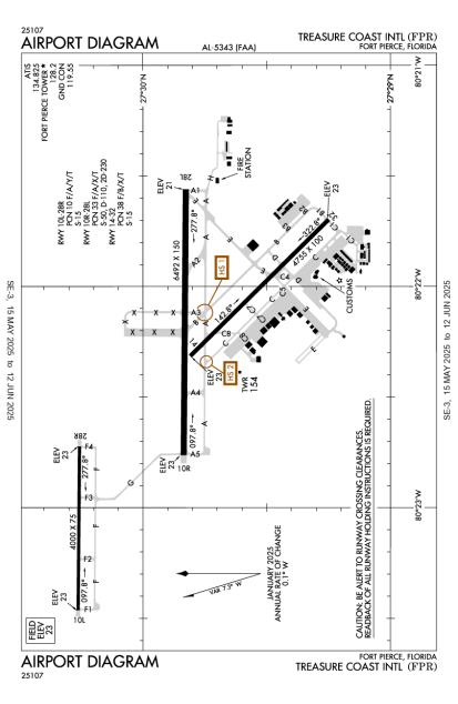
Runway 10R/28L
Dimensions:
6,492 × 150 ft
(1,979 × 46 m)
(1,979 × 46 m)
Weight Bearing Cap:
Single wheel: 50,000 lbs
Double wheel: 110,000 lbs
Double tandem: 230,000 lbs
Double wheel: 110,000 lbs
Double tandem: 230,000 lbs
Surface:
asphalt, no surface treatment, in fair condition
Runway Edge Lights:
Medium
Comments:
25' Paved Shoulders.
FAA
| Designator: | 10R | 28L |
| Elevation: | 23 ft | 21.1 ft |
| Heading: | 097° magnetic 090° true | 277° magnetic 270° true |
| Gradient: | 0.03% down | 0.03% up |
| Traffic Pattern: | Right Pattern | Left Pattern |
| Markings: | precision, in Good condition | precision, in Good condition |
| Approach Lighting: |
|
|
| Displaced Threshold: | n/a | n/a |
| ILS/LOC: | ILS/DME | n/a |
| Obstructions: | Trees, 555 ft Left ft of center, 26 ft high, 1,380 ft from end, 45:1 clearance slope | Trees, 400 ft Right ft of center, 35 ft high, 1,160 ft from end, 27:1 clearance slope |
| Comments: | Rwy 10R Approach Slp 50:1 to Aer. FAA | Rwy 28L Approach Slp 34:1 to Aer. FAA |
Runway 14/32
Dimensions:
4,755 × 100 ft
(1,449 × 30 m)
(1,449 × 30 m)
Weight Bearing Cap:
Single wheel: 15,000 lbs
Surface:
asphalt, no surface treatment, in excellent condition
Runway Edge Lights:
Medium
Comments:
50' Paved Shoulders.
FAA
| Designator: | 14 | 32 |
| Elevation: | 22.5 ft | 22.9 ft |
| Heading: | 142° magnetic 135° true | 322° magnetic 315° true |
| Gradient: | 0.01% up | 0.01% down |
| Traffic Pattern: | Right Pattern | Left Pattern |
| Markings: | non-precision, in Good condition | non-precision, in Good condition |
| Approach Lighting: |
| n/a |
| Displaced Threshold: | n/a | n/a |
| ILS/LOC: | n/a | n/a |
| Obstructions: | Trees, 260 ft Right ft of center, 32 ft high, 1,335 ft from end, 35:1 clearance slope | Trees, 220 ft Left ft of center, 43 ft high, 1,690 ft from end, 34:1 clearance slope |
| Comments: | Preferred calm wind RWY AM | n/a |
Runway 10L/28R
Dimensions:
4,000 × 75 ft
(1,219 × 23 m)
(1,219 × 23 m)
Weight Bearing Cap:
Single wheel: 15,000 lbs
Surface:
asphalt, no surface treatment, in good condition
Runway Edge Lights:
Medium
Comments:
n/a
| Designator: | 10L | 28R |
| Elevation: | 22.9 ft | 23 ft |
| Heading: | 097° magnetic 090° true | 277° magnetic 270° true |
| Gradient: | n/a | n/a |
| Traffic Pattern: | Not provided. Assume LEFT traffic pattern | Right Pattern |
| Markings: | basic, in Good condition | basic, in Good condition |
| Approach Lighting: | n/a | n/a |
| Displaced Threshold: | n/a | n/a |
| ILS/LOC: | n/a | n/a |
| Obstructions: | Power-Line, Both-Sides, 78 ft high, 1,765 ft from end, 20:1 clearance slope | Trees, 105 ft Left ft of center, 40 ft high, 840 ft from end, 16:1 clearance slope |
| Comments: | n/a | Rwy 28R Approach Slp 21:1 to Aer. FAA |
TFRs
Location: FPR
Please verify all content below using the FAA TFR Search Site or with a flight briefer.
TFR count: 0
NOTAMs
Location: FPR
Please verify all content below using the FAA NOTAM Search Site or with a flight briefer.
NOTAM count: 12 (Partial list shown. Expand to see full list HERE.)
| Number: | Start Date: (UTC) | End Date: (UTC) | Condition: |
|---|---|---|---|
| 03/002 | 03/11/2025 1136 | 09/11/2025 2332 | AIRSPACE UAS WI AN AREA DEFINED AS 1NM RADIUS OF 272904N0802643W (3.3NM WSW FPR) SFC-200FT AGL DLY 1136-2332 |
| 5/9782 | 03/06/2025 0553 | 08/24/2025 0553 | IAP TREASURE COAST INTL, FORT PIERCE, FL.
ILS OR LOC RWY 10R, AMDT 4E...
SIVYO FIX MINIMUMS (DME REQUIRED): … |
| 06/001 | 06/01/2025 0417 | 06/16/2025 0317 | OBST TOWER LGT (ASR 1046022) 272609.10N0802239.10W (3.7NM S FPR) 479.7FT (464.9FT AGL) U/S |
| 5/9784 | 03/06/2025 0555 | IAP TREASURE COAST INTL, FORT PIERCE, FL.
RNAV (GPS) RWY 10R, AMDT 2C...
RNAV (GPS) RWY 14, AMDT 2C...
RNAV … | |
| 05/005 | 05/22/2025 2246 | 06/22/2025 2359 | OBST TOWER LGT (ASR 1029543) 272626.80N0803251.30W (10.1NM WSW FPR) 336.9FT (315.0FT AGL) U/S |
| 03/006 | 03/18/2025 1502 | 09/30/2025 2359 | OBST OIL RIG (ASN 2024-ASO-12669-OE) 273058N0802322W (.5NM W FPR) 141FT (120FT AGL) FLAGGED AND LGTD |
| 05/006 | 05/06/2024 1100 | TWY C4 CLSD | |
| 05/007 | 05/25/2025 0927 | 09/22/2025 0927 | OBST TOWER LGT (ASR 1031097) 272758.70N0802754.10W (5.4NM WSW FPR) 485.9FT (461.9FT AGL) U/S |
Additional Remarks
2 Ft Drainage Ditch 367 Ft 'W' of Twy 'A1' Btwn Twy 'A' & Rwy 10L/28R.
Source:
FAA
Federal Aviation Administration
2 Ft Drainage Ditch 797 Ft Fm Thr Rwy 28L 349 Ft Left.
Source:
FAA
Federal Aviation Administration
8 Ft Fence 400 Ft Fm Cntrln on North Side of Rwy 10R/28L and East of Rwy 14/32.
Source:
FAA
Federal Aviation Administration
Drainage Channel 80 Ft Wide, 10 Ft Deep 530 Ft Approach End of Runway 28R. 2 Ft Drainage Ditch 361 Ft Fr Ry 10R Thld 259 Ft Right.
Source:
FAA
Federal Aviation Administration
Drainage Channel 80 Ft Wide, 10 Ft Deep, 600 Ft Fm Approach End of Runway 10L.
Source:
FAA
Federal Aviation Administration
Extensive Flight Training on and Within 20 Miles of Airport Blo 6000 Ft. VFR Training Acft Outside of Class D Airspace Transmit Intended Activity on 123.3.
Source:
FAA
Federal Aviation Administration
For Cd, If Una Via Gco, CTC Palm Beach Approach at 561-684-9047 or 561-275-1430.
Source:
FAA
Federal Aviation Administration
Gco Avbl on Freq 119.55 Palm Beach Cd.
Source:
FAA
Federal Aviation Administration
High Tension Plines 1/4 Sm 'W' Approach End of Runway 10L Unmkd & Unlighted.
Source:
FAA
Federal Aviation Administration
Lgtd Arff Com Ant 125 Ft AGL (149 Ft Amsl) Lctd 793 Ft Sse of Rwy 27 Thld.
Source:
FAA
Federal Aviation Administration
Numerous Flocks of Birds & Wildlife on and In vicinity of Arpt.
Source:
FAA
Federal Aviation Administration
Rwy 10L/28R VFR Trng Rwy.
Source:
FAA
Federal Aviation Administration
Twy C1 Restricted to Acft with A Wing Span of 105 Ft or Less.
Source:
FAA
Federal Aviation Administration
Voluntary Noise Abatement Procs in Efct, CTC Airport Mgmt At 772-462-1732.
Source:
FAA
Federal Aviation Administration
Noise Abatement
| Runway: | Applies to: | Approach/Departure: | Text: |
|---|---|---|---|
| All | All Aircraft | Departure | All aircraft takeoffs should be made utilizing the best rate of climb of speed |
| 10L | All Aircraft | Both | When using training RWY 10L/28R, stay south of Indrio Road |
| 28R | All Aircraft | Both | When using training RWY 10L/28R, stay south of Indrio Road |
Instrument Procedures
Operations & More Information
Lat/Long:
- 27.49747, -80.37264
- 27° 29′ 50.9″ N, 80° 22′ 21.5″ W
- 27° 29.848′ N, 80° 22.358′ W
ARTCC:
Miami (ZMA)
App/Depart Control Facility:
Unknown
Chart:
NACO: Miami Sectional
FSS:
Miami (MIA)
1-800-WX-BRIEF
1-800-WX-BRIEF
Wind Indicator:
Lighted
Mag Var:
07W (2015)
NOTAM Facility:
Seg Circle:
Yes
Beacon:
Present
Lighting:
Actvt REIL Rwy 10R & 28L; MIRL Rwy 10L/28R, 10R/28L & 14/32 - CTAF.
FAA
Pattern Altitude:
No data provided. Assume 1000 AGL.
Special Operations:
Communications Card
| Type: | Frequency / Phone: | Sector / Comments: | Call Sign: |
|---|---|---|---|
| Approach/Departure | 132.8 | SOUTH | Miami Artcc |
| ASOS | (772) 489-4281 | Ft Pierce | |
| ATIS | 134.825 | Ft Pierce | |
| CTAF | 128.2 | Ft Pierce | |
| Ground Control | 119.55 | Ft Pierce | |
| Tower | 128.2 | Ft Pierce |
Navaids
Services
Fuel:
100LL Low-Lead, Jet A
AM
Engine Repair:
Major
AM
Airframe Repair:
Major
AM
Bottled Oxygen:
None
Bulk Oxygen:
High/Low
AM
Customs:
International Landing Rights
AM
Transportation:
Courtesy Transportation
AM
Activities:
Intensive Flight Training, On field restaurant/café
AM
Camping On Field:
None Reported
Aircraft & Activity
Webcams
METARs
TAFs
Contact Addresses
Airport Manager
Cameron Howard
Ft Pierce, FL 34946
(772) 462-1727 (Office)
Owner
St. Lucie County
Ft Pierce, FL 34982-5652
(772) 462-1732 (Office)
Airport Reviews
Overall:
2 ratings | 4 reviews
Runways and Taxiways:No ratings
Markings and Signage:No ratings
Ground Transportation:No ratings
Sort By:
- 4/1/19Robert R.returned from bhs on a busy sat.3-9.and gear would not lock down so after low tower pass to confirm not many options left.controlers were very professional and patient. they had all other aircraft circle to wait, told me no hurry the airport was mine…
- 12/26/20T.C. Aircraft SolutionsLAWRENCE L.Had T.C.(Treasure Coast) Aircraft Solutions do my annual Jan 2020. In my almost 50 years flying have never had a worse experience. Trevor removed one of my com antennas thinking it was an ELT antenna. Had to sue him to get it back. Quotes one price …
- 6/15/15EDMOND G.Fly and dive trip to the Bahamas - very satisfying experience. Self-fueled and the system was top notch, easy to use, standard interface and easily accessible. Fuel prices were very good. Controllers were helpful and ground control accommodating abou…
- 7/30/14RALPH T.One of the best airports I've experienced. Everyone was very welcoming from the TWR personnel to the APP FBO employees. Jet A was almost $2 cheaper than KFXE or KSUA (lousy personnel). And, the restaurant was outstanding at APP. It is my new "go to" …