FAA Information Effective: Jun 12, 2025
All information is provided from the FAA unless otherwise noted.
(KAHQ) Wahoo Municipal Airport
No ratings | No reviews
Wahoo, NE
(402) 882-2717
Overview
Attendance:
Attended
Year-round, 7 Days a Week,Dawn-Dusk
FAA
Elevation:
1,226 ft (Surveyed)
Tower:
No
Airspace:
Unknown
Fees:
Landing, Overnight, Ramp, Other
Click FBO link(s) below for details:
Click FBO link(s) below for details:
FBO Fee Details:
Wahoo Airport AuthorityTimezone:
CDT (UTC-05:00)
Sunrise-Sunset:
5:54 am - 9:03 pm
Evening-Morning Civil Twilight:
9:37 pm
(Today)
(Today)
-
5:20 am
(Tomorrow)
(Tomorrow)
Minimum Fuel Prices:
$5.75
100LL (self)
$4.25
Jet-A (self)
Runway
Satellite
Sectional
FBOs
Submit New FBO
Wahoo Airport Authority
No ratings | Be the first to review this business
Services Offered:
$5.75 | 100LL | self
$4.25 | Jet-A | self
Location:
On field: W
Phone:
(402) 882-2717
Freq. Monitored:
Fees:
Landing, Overnight, Ramp, Other
Flight Training
Submit New Flight School
Other businesses
Submit New Business
AOPA Travel Discounts 
FlightBridge is the ultimate all-in-one travel booking platform built for the general aviation community. AOPA Members receive free access to FlightBridge with AOPA discounted rates automatically applied. Members save an average of 30% on hotel bookings! Learn more about FlightBridge HERE.
Local Food/Lodging/Activities
Local Attractions
Local Activities
Restaurants
Hotels and Lodging
Travel Discounts
Chip's Restaurant & Bar
(402) 277-5161
Wigwam Cafe'
(402) 443-5575
Hao's Garden
(402) 443-3888
6th Street Garage Bar
(402) 443-4328
Stockyard Cafe'
(402) 443-1373
Wigwam Cafe
(402) 443-5575
AHQ
Chip's Restaurant & Bar
Wigwam Cafe'
Hao's Garden
6th Street Garage Bar
Stockyard Cafe'
Wigwam Cafe
Flying Clubs
Submit New Flying Club
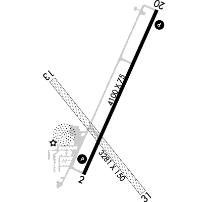
Runway 02/20
Dimensions:
4,100 × 75 ft
(1,250 × 23 m)
(1,250 × 23 m)
Weight Bearing Cap:
Single wheel: 20,000 lbs
Surface:
concrete, no surface treatment, in good condition
Runway Edge Lights:
Medium
Comments:
n/a
| Designator: | 02 | 20 |
| Elevation: | 1,221.6 ft | 1,225.5 ft |
| Heading: | 018° magnetic 024° true | 198° magnetic 204° true |
| Gradient: | 0.1% up | 0.1% down |
| Traffic Pattern: | Left Pattern | Left Pattern |
| Markings: | non-precision, in Good condition | non-precision, in Good condition |
| Approach Lighting: |
|
|
| Displaced Threshold: | n/a | n/a |
| ILS/LOC: | n/a | n/a |
| Obstructions: | n/a | n/a |
| Comments: | Elevator Leg. FAA Rwy 02 Hwy 850 Ft Fm End 0B Also 36:1. FAA | n/a |
Runway 13/31
Dimensions:
3,281 × 150 ft
(1,000 × 46 m)
(1,000 × 46 m)
Weight Bearing Cap:
n/a
Surface:
turf, grass, sod, no surface treatment, in fair condition
Runway Edge Lights:
n/a
Comments:
n/a
| Designator: | 13 | 31 |
| Elevation: | 1,223.3 ft | 1,220.9 ft |
| Heading: | 135° magnetic 141° true | 315° magnetic 321° true |
| Gradient: | 0.07% down | 0.07% up |
| Traffic Pattern: | Left Pattern | Left Pattern |
| Markings: | n/a | n/a |
| Approach Lighting: | n/a | n/a |
| Displaced Threshold: | n/a | n/a |
| ILS/LOC: | n/a | n/a |
| Obstructions: | n/a | n/a |
| Comments: | n/a | n/a |
TFRs
Location: AHQ
Please verify all content below using the FAA TFR Search Site or with a flight briefer.
TFR count: 0
NOTAMs
Location: AHQ
Please verify all content below using the FAA NOTAM Search Site or with a flight briefer.
NOTAM count: 6
| Number: | Start Date: (UTC) | End Date: (UTC) | Condition: |
|---|---|---|---|
| 06/028 | 06/05/2025 1914 | 06/25/2025 2359 | AD AP JET A FUEL NOT AVBL |
| 04/039 | 04/11/2025 0711 | 07/14/2025 2359 | OBST TOWER LGT (ASR 1211851) 410622.00N0964937.10W (13.3NM SW AHQ) 1875.0FT (397.0FT AGL) U/S |
| 05/093 | 05/22/2025 1721 | NAV NDB NOT MNT | |
| 04/104 | 04/29/2025 1953 | OBST TOWER LGT (ASR 1029935) 410818.00N0962721.00W (8.8NM SE AHQ) 2024.6FT (848.8FT AGL) U/S | |
| 04/095 | 04/28/2025 1934 | 10/31/2025 2359 | OBST WATER TOWER LGT (ASN UNKNOWN) 411141N0964424W (7NM WSW AHQ) UNKNOWN (200FT AGL) NOT LGTD |
| 06/073 | 06/14/2025 1400 | 06/26/2025 2359 | AIRSPACE SEE ZMP 06/209 NUMEROUS ACFT TRG DLY 1400-2359 |
Additional Remarks
For Clearance Delivery Contact Omaha Approach at 402-682-4395.
Source:
FAA
Federal Aviation Administration
Ry 13/31 not Plowed Winter Months.
Source:
FAA
Federal Aviation Administration
Noise Abatement
Instrument Procedures
Data Cycle:
Operations & More Information
Lat/Long:
- 41.24061, -96.59455
- 41° 14′ 26.2″ N, 96° 35′ 40.4″ W
- 41° 14.436′ N, 96° 35.673′ W
ARTCC:
Minneapolis (ZMP)
App/Depart Control Facility:
R90
Chart:
NACO: Omaha Sectional
FSS:
Columbus (OLU)
1-800-WX-BRIEF
1-800-WX-BRIEF
Wind Indicator:
Lighted
Mag Var:
06E (1990)
NOTAM Facility:
Seg Circle:
Yes
Beacon:
Present
Lighting:
Pilot Activated Lighting:
- low intensity: 5 clicks in 5 secs
AM
Actvt REIL Rwy 02 & 20; PAPI Rwy 02 & 20; MIRL 02/20 - CTAF.
FAA
Pattern Altitude:
Light Aircraft 2223 MSL
AM
Special Operations:
Communications Card
| Type: | Frequency / Phone: | Sector / Comments: | Call Sign: |
|---|---|---|---|
| Approach/Departure | 135.875 | Omaha | |
| AWOS-3P | 125.975T (402) 443-4030 | ||
| Clearance Delivery Phone | (402) 682-4395 | Omaha Approach | |
| CTAF | 122.7 | ||
| UNICOM | 122.7 |
Navaids
Services
Fuel:
100LL Low-Lead, Jet A
AM
Engine Repair:
Major
AM
Airframe Repair:
Major
AM
Bottled Oxygen:
None
Bulk Oxygen:
None
Customs:
None
Transportation:
Courtesy Transportation
AM
Activities:
None Reported
Camping On Field:
None Reported
Aircraft & Activity
Webcams
METARs
TAFs
Contact Addresses
Airport Manager
Evan Taylor
Wahoo, NE 68066-0122
(402) 882-2717 (Office)
Owner
Wahoo Airport Authority
Wahoo, NE 68066-0122
(402) 443-3222 (Office)
Remarks:
Brian Homes - Airport Authority Chairman.
FAA