FAA Information Effective: May 15, 2025
All information is provided from the FAA unless otherwise noted.
(KBVO) Bartlesville Municipal Airport
No ratings | No reviews
Bartlesville, OK
(918) 661-3500
Overview
Attendance:
Attended
Year-round,Fri-Sun/0700-1800
FAA
Year-round,Mon-Thu/0700-1900
FAA
Runways:
17/35
Runway length: 6,850 ft (2,088 m)
Elevation:
717 ft (Surveyed)
Tower:
No
Airspace:
CLASS E SVC MON-THU 1300-0100Z++, FRI 1300-2300Z++; OTHER TIMES CLASS G
FAA
Fees:
Landing, Ramp, Tie Down, Other
Click FBO link(s) below for details:
Click FBO link(s) below for details:
FBO Fee Details:
Phillips Aviation ServicesTimezone:
CDT (UTC-05:00)
Sunrise-Sunset:
6:06 am - 8:41 pm
Evening-Morning Civil Twilight:
9:11 pm
(Today)
(Today)
-
5:36 am
(Tomorrow)
(Tomorrow)
Minimum Fuel Prices:
$4.99
100LL (full)
$4.15
Jet-A (full)
Runway
Satellite
Sectional
FBOs
Submit New FBO
Phillips Aviation Services
2 ratings | 2 reviews
Services Offered:
Car Rental
$4.99 | 100LL | full
$4.15 | Jet-A | full
Location:
On field: NE
Phone:
(918) 661-3121
Freq. Monitored:
UNICOM: 123
Fees:
Landing, Ramp, Tie Down, Other
Flight Training
Submit New Flight School
Other businesses
Submit New Business
AOPA Travel Discounts 
FlightBridge is the ultimate all-in-one travel booking platform built for the general aviation community. AOPA Members receive free access to FlightBridge with AOPA discounted rates automatically applied. Members save an average of 30% on hotel bookings! Learn more about FlightBridge HERE.
Local Food/Lodging/Activities
Local Attractions
Local Activities
Restaurants
Hotels and Lodging
Travel Discounts
Flying Clubs
Submit New Flying Club
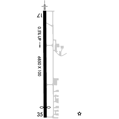
Runway 17/35
Dimensions:
6,850 × 100 ft
(2,088 × 30 m)
(2,088 × 30 m)
Weight Bearing Cap:
Single wheel: 50,000 lbs
Double wheel: 100,000 lbs
Double tandem: 170,000 lbs
Double wheel: 100,000 lbs
Double tandem: 170,000 lbs
Surface:
concrete, grooved, in good condition
Runway Edge Lights:
Medium
Comments:
n/a
| Designator: | 17 | 35 |
| Elevation: | 685.5 ft | 716.9 ft |
| Heading: | 176° magnetic 179° true | 356° magnetic 359° true |
| Gradient: | 0.46% up | 0.46% down |
| Traffic Pattern: | Right Pattern | Left Pattern |
| Markings: | precision, in Good condition | precision, in Good condition |
| Approach Lighting: |
|
|
| Displaced Threshold: | n/a | 649 ft |
| ILS/LOC: | Localizer | n/a |
| Obstructions: | Trees, 344 ft Right ft of center, 31 ft high, 572 ft from end, 12:1 clearance slope | n/a |
| Comments: | n/a | n/a |
TFRs
Location: BVO
Please verify all content below using the FAA TFR Search Site or with a flight briefer.
TFR count: 0
NOTAMs
Location: BVO
Please verify all content below using the FAA NOTAM Search Site or with a flight briefer.
NOTAM count: 9 (Partial list shown. Expand to see full list HERE.)
| Number: | Start Date: (UTC) | End Date: (UTC) | Condition: |
|---|---|---|---|
| 05/004 | 05/07/2025 0931 | 06/07/2025 2359 | OBST TOWER LGT (ASN 2019-ASW-8219-OE) 364718N0960144W (1.7NM NNW BVO) 919FT (75FT AGL) U/S |
| 06/004 | 06/03/2025 2337 | 06/18/2025 2359 | OBST TOWER LGT (ASR 1325572) 364334.30N0955325.80W (6.22NM ESE BVO) 1006FT (225FT AGL) U/S |
| 04/018 | 04/29/2025 1325 | 07/29/2025 2359 | OBST TOWER LGT (ASR 1249366) 363501.00N0955648.00W (11.2NM SSE BVO) 943.6FT (234.9FT AGL) U/S |
| 05/007 | 05/14/2025 1624 | 06/28/2025 1624 | OBST TOWER LGT (ASR 1062788) 363731.90N0955559.90W (9.1NM SSE BVO) 1030.8FT (301.8FT AGL) U/S |
| 05/009 | 05/19/2025 2052 | 06/19/2025 2359 | OBST TOWER LGT (ASR 1013961) 363948.00N0960145.00W (6.1NM S BVO) 1361.9FT (319.9FT AGL) U/S |
| 06/026 | 06/29/2024 1231 | OBST TOWER LGT (ASN 2019-ASW-14286-OE) 364714N0960153W (1.7NM NW BVO) 920FT (85FT AGL) U/S | |
| 06/005 | 06/04/2025 1258 | 07/07/2025 2359 | RWY 35 RWY END ID LGT U/S |
| 05/006 | 05/12/2025 0217 | OBST TOWER LGT (ASN 2019-ASW-8206-OE) 364736N0960006W (1.9NM NNE BVO) 934FT (60FT AGL) U/S | |
Additional Remarks
For Cd If Una to CTC on FSS Freq, CTC Kansas City ARTCC at 913-254-8508.
Source:
FAA
Federal Aviation Administration
Noise Abatement
Instrument Procedures
Data Cycle:
Operations & More Information
Lat/Long:
- 36.76336, -96.01119
- 36° 45′ 48.1″ N, 96° 0′ 40.3″ W
- 36° 45.802′ N, 96° 0.672′ W
ARTCC:
Kansas City (ZKC)
App/Depart Control Facility:
Unknown
Chart:
NACO: Kansas City Sectional
FSS:
Mc Alester (MLC)
1-800-WX-BRIEF
1-800-WX-BRIEF
Wind Indicator:
Lighted
Mag Var:
03E (2020)
NOTAM Facility:
Seg Circle:
Yes
Beacon:
Present
Lighting:
Pilot Activated Lighting:
- low intensity: 3 clicks in 5 secs
- medium intensity: 5 clicks in 5 secs
- high intensity: 7 clicks in 5 secs
AM
Actvt MALSR Rwy 17; REIL Rwy 35; PAPI Rwy 17 & 35 - CTAF. MIRL Rwy 17/35 Oper Ss to Sr & Preset Low Intst, Incr Intst - CTAF.
FAA
Pattern Altitude:
No data provided. Assume 1000 AGL.
Special Operations:
Communications Card
| Type: | Frequency / Phone: | Sector / Comments: | Call Sign: |
|---|---|---|---|
| ASOS | 132.675T (918) 336-2070 | ||
| CTAF | 122.825 |
Navaids
Services
Fuel:
100LL Low-Lead
AM
Engine Repair:
Major
AM
Airframe Repair:
Major
AM
Bottled Oxygen:
Low
AM
Bulk Oxygen:
None
Customs:
None
Transportation:
Courtesy Transportation
AM
Activities:
None Reported
Camping On Field:
None Reported
Aircraft & Activity
Webcams
METARs
TAFs
Contact Addresses
Airport Manager
Mike Richardson
Bartlesville, OK 74003
(918) 661-3500 (Office)
Owner
City of Bartlesville
Bartlesville, OK 74003
(918) 338-4282 (Office)
Remarks:
For Emerg Only 918-350-0076.
FAA