FAA Information Effective: Jul 10, 2025
All information is provided from the FAA unless otherwise noted.
(KFSE) Fosston Muni/Anderson Field
No ratings | No reviews
Overview
Attendance:
Unattended
Unattended
FAA
Runways:
16/34
Runway length: 3,502 ft (1,067 m)
Elevation:
1,279 ft (Surveyed)
Tower:
No
Airspace:
Unknown
Fees:
Timezone:
CDT (UTC-05:00)
Sunrise-Sunset:
5:53 am - 9:08 pm
Evening-Morning Civil Twilight:
9:45 pm
(Today)
(Today)
-
5:17 am
(Tomorrow)
(Tomorrow)
Minimum Fuel Prices:
$4.65
100LL (self)
Runway
Satellite
Sectional
FBOs
Submit New FBO
City of Fosston
No ratings | Be the first to review this business
Services Offered:
$4.65 | 100LL | self
Location:
On field: S
Phone:
(218) 435-1959
Freq. Monitored:
Fees:
Landing, Overnight, Ramp, Other
Flight Training
Submit New Flight School
Other businesses
Submit New Business
AOPA Travel Discounts 
FlightBridge is the ultimate all-in-one travel booking platform built for the general aviation community. AOPA Members receive free access to FlightBridge with AOPA discounted rates automatically applied. Members save an average of 30% on hotel bookings! Learn more about FlightBridge HERE.
Local Food/Lodging/Activities
Local Attractions
Local Activities
Restaurants
Hotels and Lodging
Travel Discounts
Fosston Golf Club
Dairy Queen
435-1095
FSE
Fosston Golf Club
Dairy Queen
Flying Clubs
Submit New Flying Club
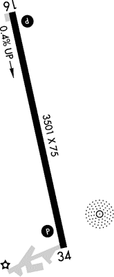
Runway 16/34
Dimensions:
3,502 × 75 ft
(1,067 × 23 m)
(1,067 × 23 m)
Weight Bearing Cap:
Single wheel: 13,000 lbs
Surface:
asphalt, no surface treatment, in good condition
Runway Edge Lights:
Non-standard
Comments:
Nstd MIRL Due to Rwy 34 Lgts not Yellow Last Half Rwy Len.
FAA
| Designator: | 16 | 34 |
| Elevation: | 1,266.3 ft | 1,278.7 ft |
| Heading: | 164° magnetic 167° true | 344° magnetic 347° true |
| Gradient: | 0.35% up | 0.35% down |
| Traffic Pattern: | Left Pattern | Left Pattern |
| Markings: | non-precision, in Fair condition | non-precision, in Fair condition |
| Approach Lighting: |
|
|
| Displaced Threshold: | n/a | n/a |
| ILS/LOC: | n/a | n/a |
| Obstructions: | Trees, 269 ft Left ft of center, 46 ft high, 423 ft from end, 4:1 clearance slope | Road, 315 ft Left ft of center, 19 ft high, 800 ft from end, 31:1 clearance slope |
| Comments: | 3 Ft Crops, 43 Ft Dist, 158 Ft R. FAA | n/a |
TFRs
Location: FSE
Please verify all content below using the FAA TFR Search Site or with a flight briefer.
TFR count: 0
NOTAMs
Location: FSE
Please verify all content below using the FAA NOTAM Search Site or with a flight briefer.
NOTAM count: 6
| Number: | Start Date: (UTC) | End Date: (UTC) | Condition: |
|---|---|---|---|
| 06/002 | 06/09/2025 1258 | RWY 16 RWY END ID LGT NOT STD | |
| 07/003 | 07/21/2025 1713 | SVC AUTOMATED WX BCST SYSTEM U/S | |
| 06/003 | 06/18/2025 1130 | 09/16/2025 0400 | OBST TOWER LGT (ASR 1211108) 473626.80N0955119.10W (3.4NM WNW FSE) 1509.8FT (254.9FT AGL) U/S |
| 05/001 | 05/10/2025 1254 | 08/08/2025 2359 | OBST TOWER LGT (ASN 2025-AGL-5795-OE) 473421N0954212W (3.1NM ESE FSE) 1618FT (315FT AGL) U/S |
| 06/001 | 06/09/2025 1254 | RWY 34 PAPI U/S | |
| 04/003 | 04/28/2025 1217 | RWY 16 PAPI U/S | |
Additional Remarks
For Cd If Una Via GCO CTC Minneapolis ARTCC at 651-463-5588.
Source:
FAA
Federal Aviation Administration
Gco Avbl on Freq 121.725 Thru Minneapolis ARTCC & Flt Svcs.
Source:
FAA
Federal Aviation Administration
Noise Abatement
Instrument Procedures
Data Cycle:
Operations & More Information
Lat/Long:
- 47.59283, -95.77349
- 47° 35′ 34.2″ N, 95° 46′ 24.6″ W
- 47° 35.570′ N, 95° 46.409′ W
ARTCC:
Minneapolis (ZMP)
App/Depart Control Facility:
Unknown
Chart:
NACO: Twin Cities Sectional
FSS:
Princeton (PNM)
1-800-WX-BRIEF
1-800-WX-BRIEF
Wind Indicator:
Lighted
Mag Var:
03E (2010)
NOTAM Facility:
Seg Circle:
No
Beacon:
Present
Lighting:
Pilot Activated Lighting:
- medium intensity: 5 clicks in 5 secs
AM
Actvt or Incr Intst REIL Rwy 16 & 34; PAPI Rwy 16 & 34; Nstd MIRL Rwy 16/34 - CTAF. Nstd MIRL Rwy 16/34 Preset Low Intst.
FAA
Pattern Altitude:
Light Aircraft 2070 MSL
AM
Special Operations:
Communications Card
| Type: | Frequency / Phone: | Sector / Comments: | Call Sign: |
|---|---|---|---|
| AWOS-3 | 118.35T (218) 435-6448 | ||
| CTAF | 122.9 |
Navaids
Services
Fuel:
100LL Low-Lead
AM
Engine Repair:
None
Airframe Repair:
None
Bottled Oxygen:
None
Bulk Oxygen:
None
Customs:
None
Transportation:
None Reported
AM
Activities:
None Reported
Camping On Field:
None Reported
Aircraft & Activity
Webcams
METARs
METARs from this airport:
METARs from nearby reporting stations:
TAFs
TAFs from nearby airports:
KTVF TAF
32 nm NW
Issued:
11:20 PM GMT
(5 hours ago)
Today 12:00 AM - 8:00 AM GMT
Today 8:00 AM - 12:00 PM GMT
Vis:
6+
SM
Wind:
@
12
KT
Cld:
- Overcast 4000' AGL
Wx:
Thunderstorm, Light Rain
Today 12:00 PM - 6:00 PM GMT
Today 6:00 PM - Tomorrow 12:00 AM GMT
KBJI TAF
35 nm E
Issued:
11:20 PM GMT
(5 hours ago)
Today 12:00 AM - 9:00 AM GMT
Vis:
6+
SM
Wind:
@
14
KT
Cld:
- Scattered clouds 15000' AGL
Wx:
N/A
Today 9:00 AM - 1:00 PM GMT
Vis:
6+
SM
Wind:
@
9
KT
Cld:
- Overcast 6000' AGL
Wx:
Thunderstorm, Light Rain
Today 1:00 PM - 5:00 PM GMT
Today 5:00 PM - Tomorrow 12:00 AM GMT
KFAR TAF
58 nm SW
Issued:
11:20 PM GMT
(5 hours ago)
Today 12:00 AM - 5:00 AM GMT
Vis:
6+
SM
Wind:
@
13
G
25
KT
Cld:
- Few clouds 5000' AGL
Wx:
N/A
Today 5:00 AM - 8:00 AM GMT
Vis:
6+
SM
Wind:
@
14
KT
Cld:
- Scattered clouds 24000' AGL
Wx:
Thunderstorm in vicinity
Today 8:00 AM - 1:00 PM GMT
Vis:
6+
SM
Wind:
@
12
KT
Cld:
- Overcast 4000' AGL
Wx:
Thunderstorm, Light Rain
Today 1:00 PM - 6:00 PM GMT
Today 6:00 PM - Tomorrow 12:00 AM GMT
Contact Addresses
Airport Manager
Cassie Heide
Fosston, MN 56542-1337
(218) 435-1959 (Office)
Owner
City of Fosston
Fosston, MN 56542-1337
(218) 435-1959 (Office)
Airport Reviews
Nearby Events
- safety seminarIMC Club Monthly - 2nd Wednesday 7PM Flight Level FBO06/11/2025 - 06/11/2026Location: Norwood Airport, Flight Level Aviation, 2nd FloorDescription:Have fun with fellow pilots reviewing pilot shared flight scenarios. No membership required. FAAST Wing Credit Eligible, OWD-BED greater area pilots welcome.
- airshowCole Palen's Old Rhinebeck Aerodrome Air Shows - First Responders08/02/2025 - 08/03/2025Location: Old Rhinebeck Aerodrome
 Description:Cole Palen's Old Rhinebeck Aerodrome Air Shows 2025 Air Show Schedule: Every Saturday and Sunday June 14-October 19.
 - airshowCole Palen's Old Rhinebeck Aerodrome Air Shows - Red Hook Car Club, British Car Club08/09/2025 - 08/10/2025Location: Old Rhinebeck AerodromeDescription:Cole Palen's Old Rhinebeck Aerodrome Air Shows 2025 Air Show Schedule: Every Saturday and Sunday June 14-October 19.
- airshowCole Palen's Old Rhinebeck Aerodrome Air Shows - Steampunk Weekend08/16/2025 - 08/17/2025Location: Old Rhinebeck AerodromeDescription:Cole Palen's Old Rhinebeck Aerodrome Air Shows 2025 Air Show Schedule: Every Saturday and Sunday June 14-October 19.
- aopa rusty pilotsAOPA Rusty Pilots Seminar at Westfield-Barnes Regional Airport (BAF)08/23/2025Location: Fly Lugu Flight Training
 Description:Life may have gotten in the way, but the dream of flight can be yours again. Returning to the skies is not as difficult as most rusty pilots think.
 - airshowCole Palen's Old Rhinebeck Aerodrome Air Shows - RC Jamboree09/05/2025 - 09/07/2025Location: Old Rhinebeck AerodromeDescription:Cole Palen's Old Rhinebeck Aerodrome Air Shows 2025 Air Show Schedule: Every Saturday and Sunday June 14-October 19.
- airshowCole Palen's Old Rhinebeck Aerodrome Air Shows - Women in Aviation09/13/2025 - 09/14/2025Location: Old Rhinebeck AerodromeDescription:Cole Palen's Old Rhinebeck Aerodrome Air Shows 2025 Air Show Schedule: Every Saturday and Sunday June 14-October 19.
- aviation community day
 Description:The New Jersey Aviation Hall of Fame will Host an Open Cockpit Day 10:30 AM to 4 PM, Last Admission 2:45 PM 400 Fred Wehran Dr, Teterboro, NJ 07608 No Reservations Required! We will be fully staffed!
 - airshowCole Palen's Old Rhinebeck Aerodrome Air Shows - Artists Weekend09/20/2025 - 09/21/2025Location: Old Rhinebeck AerodromeDescription:Cole Palen's Old Rhinebeck Aerodrome Air Shows 2025 Air Show Schedule: Every Saturday and Sunday June 14-October 19.
- airshowCole Palen's Old Rhinebeck Aerodrome Air Shows - Photographers Weekend10/04/2025 - 10/05/2025Location: Old Rhinebeck AerodromeDescription:Cole Palen's Old Rhinebeck Aerodrome Air Shows 2025 Air Show Schedule: Every Saturday and Sunday June 14-October 19.
- airshowCole Palen's Old Rhinebeck Aerodrome Air Shows - Pumpkin Bombing10/11/2025 - 10/12/2025Location: Old Rhinebeck AerodromeDescription:Cole Palen's Old Rhinebeck Aerodrome Air Shows 2025 Air Show Schedule: Every Saturday and Sunday June 14-October 19.
- aviation community dayDescription:The New Jersey Aviation Hall of Fame will Host an Open Cockpit Day 10:30 AM to 4 PM, Last Admission 2:45 PM 400 Fred Wehran Dr, Teterboro, NJ 07608 No Reservations Required! We will be fully staffed!
- airshowCole Palen's Old Rhinebeck Aerodrome Air Shows - Pumpkin Bombing (last show weekend)10/18/2025 - 10/19/2025Location: Old Rhinebeck AerodromeDescription:Cole Palen's Old Rhinebeck Aerodrome Air Shows 2025 Air Show Schedule: Every Saturday and Sunday June 14-October 19.
- aviation community dayDescription:The New Jersey Aviation Hall of Fame will Host an Open Cockpit Day 10:30 AM to 4 PM, Last Admission 2:45 PM 400 Fred Wehran Dr, Teterboro, NJ 07608 No Reservations Required! We will be fully staffed!