FAA Information Effective: Jul 10, 2025
All information is provided from the FAA unless otherwise noted.
(KGNC) Gaines County Airport
No ratings | No reviews
Seminole, TX
(432) 788-7657
Overview
Attendance:
Attended
Year-round,Mon-Fri/0800-1800
FAA
Year-round,Sat/0800-1200
FAA
Elevation:
3,315 ft (Surveyed)
Tower:
No
Airspace:
Unknown
Fees:
Timezone:
CDT (UTC-05:00)
Sunrise-Sunset:
7:01 am - 8:54 pm
Evening-Morning Civil Twilight:
9:21 pm
(Today)
(Today)
-
6:35 am
(Tomorrow)
(Tomorrow)
Minimum Fuel Prices:
$5.45
100LL (full)
$5.45
100LL (self)
$4.30
Jet-A-Premix/Prist (full)
Runway
Satellite
Sectional
FBOs
Submit New FBO
FlyTex Aviation, LLC
No ratings | Be the first to review this business
Services Offered:
Maintenance
$5.45 | 100LL | full
$5.45 | 100LL | self
$4.30 | Jet-A-Premix/Prist | full
Location:
On field: NE
Phone:
(432) 788-7137
Freq. Monitored:
Fees:
Ramp, Other
Flight Training
Submit New Flight School
Other businesses
Submit New Business
AOPA Travel Discounts 
FlightBridge is the ultimate all-in-one travel booking platform built for the general aviation community. AOPA Members receive free access to FlightBridge with AOPA discounted rates automatically applied. Members save an average of 30% on hotel bookings! Learn more about FlightBridge HERE.
Local Food/Lodging/Activities
Local Attractions
Local Activities
Restaurants
Hotels and Lodging
Travel Discounts
Flying Clubs
Submit New Flying Club
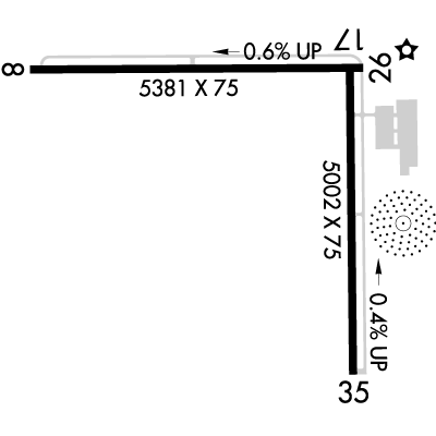
Runway 08/26
Dimensions:
5,381 × 75 ft
(1,640 × 23 m)
(1,640 × 23 m)
Weight Bearing Cap:
Single wheel: 13,000 lbs
Surface:
asphalt, no surface treatment, in fair condition
Runway Edge Lights:
Medium
Comments:
n/a
| Designator: | 08 | 26 |
| Elevation: | 3,313.1 ft | 3,282.5 ft |
| Heading: | 081° magnetic 090° true | 261° magnetic 270° true |
| Gradient: | 0.57% down | 0.57% up |
| Traffic Pattern: | Left Pattern | Not provided. Assume LEFT traffic pattern |
| Markings: | basic, in Poor condition | basic, in Poor condition |
| Approach Lighting: |
|
|
| Displaced Threshold: | n/a | n/a |
| ILS/LOC: | n/a | n/a |
| Obstructions: | n/a | Power-Line, Both-Sides, 30 ft high, 848 ft from end, 21:1 clearance slope |
| Comments: | Rwy Mrkgs Faded. FAA | Rwy Mrkgs Faded. FAA |
Runway 17/35
Dimensions:
5,002 × 75 ft
(1,525 × 23 m)
(1,525 × 23 m)
Weight Bearing Cap:
Single wheel: 13,000 lbs
Surface:
asphalt, no surface treatment, in good condition
Runway Edge Lights:
Medium
Comments:
n/a
| Designator: | 17 | 35 |
| Elevation: | 3,283.7 ft | 3,265 ft |
| Heading: | 170° magnetic 179° true | 350° magnetic 359° true |
| Gradient: | 0.37% down | 0.37% up |
| Traffic Pattern: | Left Pattern | Left Pattern |
| Markings: | non-precision, in Fair condition | non-precision, in Fair condition |
| Approach Lighting: |
|
|
| Displaced Threshold: | n/a | n/a |
| ILS/LOC: | n/a | n/a |
| Obstructions: | Power-Line, Both-Sides, 30 ft high, 1,200 ft from end, 33:1 clearance slope | n/a |
| Comments: | 169 Ft Ant 410 Ft Right of Cntrln. FAA | n/a |
TFRs
Location: GNC
Please verify all content below using the FAA TFR Search Site or with a flight briefer.
TFR count: 0
NOTAMs
Location: GNC
Please verify all content below using the FAA NOTAM Search Site or with a flight briefer.
NOTAM count: 2
| Number: | Start Date: (UTC) | End Date: (UTC) | Condition: |
|---|---|---|---|
| 5/9383 | 06/05/2025 1348 | IAP GAINES COUNTY, SEMINOLE, TX.
RNAV (GPS) RWY 35, AMDT 1A...
CIRCLING CAT C MDA 3960/HAA 645.
2506051348-2… | |
| 07/004 | 07/22/2025 0522 | 08/22/2025 0152 | OBST TOWER LGT (ASR 1024011) 324456.30N1024133.40W (4.8NM NNW GNC) 3763.5FT (413.7FT AGL) U/S |
Additional Remarks
(Contact Phone Nr) Jonathan@Flytexaviation.Com
Source:
FAA
Federal Aviation Administration
For Clearance Delivery Contact Fort Worth ARTCC at 817-858-7584.
Source:
FAA
Federal Aviation Administration
Noise Abatement
Instrument Procedures
Data Cycle:
Operations & More Information
Lat/Long:
- 32.67533, -102.65267
- 32° 40′ 31.2″ N, 102° 39′ 9.6″ W
- 32° 40.520′ N, 102° 39.160′ W
ARTCC:
Fort Worth (ZFW)
App/Depart Control Facility:
Unknown
Chart:
NACO: Albuquerque Sectional
FSS:
Fort Worth (FTW)
1-800-WX-BRIEF
1-800-WX-BRIEF
Wind Indicator:
Lighted
Mag Var:
09E (2000)
NOTAM Facility:
Seg Circle:
Yes
Beacon:
Present
Lighting:
Pilot Activated Lighting:
- low intensity: 3 clicks in 3 secs
- medium intensity: 5 clicks in 5 secs
- high intensity: 7 clicks in 7 secs
AM
Mirl Rwys 08/26 & 17/35 Preset Low Intst; to Incr Intst Actvt - CTAF.
FAA
Pattern Altitude:
No data provided. Assume 1000 AGL.
Special Operations:
Communications Card
| Type: | Frequency / Phone: | Sector / Comments: | Call Sign: |
|---|---|---|---|
| AWOS-3 | 118.075T (432) 758-3102 | ||
| Clearance Delivery Phone | (817) 858-7584 | Fort Worth ARTCC | |
| CTAF | 122.8 | ||
| UNICOM | 122.8 |
Navaids
Services
Fuel:
100LL Low-Lead, Jet A
AM
Engine Repair:
Major
AM
Airframe Repair:
Major
AM
Bottled Oxygen:
High
AM
Bulk Oxygen:
High
AM
Customs:
None
Transportation:
None Reported
AM
Activities:
None Reported
Camping On Field:
None Reported
Aircraft & Activity
Webcams
METARs
TAFs
Contact Addresses
Airport Manager
David Murphree
Seminole, TX 79360
(432) 788-7657 (Office)
Owner
Gaines County
Seminole, TX 79360
(432) 758-5411 (Office)
Remarks:
County Commissioner
FAA