FAA Information Effective: Jul 10, 2025
All information is provided from the FAA unless otherwise noted.
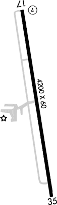
(KLUD) Decatur Municipal Airport
No ratings | No reviews
Overview
Attendance:
Attended
Year-round, 7 Days a Week,0800-1700
FAA
Runways:
17/35
Runway length: 4,200 ft (1,280 m)
Elevation:
1,047 ft (Surveyed)
Tower:
No
Airspace:
Unknown
Fees:
Timezone:
CDT (UTC-05:00)
Sunrise-Sunset:
6:39 am - 8:36 pm
Evening-Morning Civil Twilight:
9:03 pm
(Today)
(Today)
-
6:12 am
(Tomorrow)
(Tomorrow)
Minimum Fuel Prices:
$5.99
100LL (full)
$4.99
100LL (self)
$5.99
Jet-A (full)
$4.99
Jet-A (self)
Runway
Satellite
Sectional
FBOs
Submit New FBO
Decatur Jet Center
No ratings | Be the first to review this business
Services Offered:
Maintenance
Plane Rental
Car Rental
Flight Training
$5.99 | 100LL | full
$4.99 | 100LL | self
$5.99 | Jet-A | full
$4.99 | Jet-A | self
Location:
On field: W
Phone:
(940) 627-1050
Freq. Monitored:
UNICOM: 122.8
Fees:
Landing, Ramp, Other
Flight Training
Submit New Flight School
Decatur Jet Center
No ratings | Be the first to review this business
Services Offered:
Maintenance
Plane Rental
Car Rental
Flight Training
$5.99 | 100LL | full
$4.99 | 100LL | self
$5.99 | Jet-A | full
$4.99 | Jet-A | self
Location:
On field: W
Phone:
(940) 627-1050
Freq. Monitored:
UNICOM: 122.8
Fees:
Landing, Ramp, Other
Other businesses
Submit New Business
AOPA Travel Discounts 
FlightBridge is the ultimate all-in-one travel booking platform built for the general aviation community. AOPA Members receive free access to FlightBridge with AOPA discounted rates automatically applied. Members save an average of 30% on hotel bookings! Learn more about FlightBridge HERE.
Local Food/Lodging/Activities
Local Attractions
Local Activities
Restaurants
Hotels and Lodging
Travel Discounts
Flying Clubs
Submit New Flying Club
Runway 17/35
Dimensions:
4,200 × 60 ft
(1,280 × 18 m)
(1,280 × 18 m)
Weight Bearing Cap:
Single wheel: 13,000 lbs
Double wheel: 17,000 lbs
Double wheel: 17,000 lbs
Surface:
asphalt, no surface treatment, in good condition
Runway Edge Lights:
Medium
Comments:
n/a
| Designator: | 17 | 35 |
| Elevation: | 1,041.2 ft | 1,036.9 ft |
| Heading: | 169° magnetic 172° true | 349° magnetic 352° true |
| Gradient: | 0.1% down | 0.1% up |
| Traffic Pattern: | Left Pattern | Right Pattern |
| Markings: | non-precision, in Fair condition | non-precision, in Fair condition |
| Approach Lighting: |
|
|
| Displaced Threshold: | n/a | n/a |
| ILS/LOC: | n/a | n/a |
| Obstructions: | Tree, 125 ft Right ft of center, 10 ft high, 243 ft from end, 4:1 clearance slope | Power-Line, 230 ft Right ft of center, 28 ft high, 760 ft from end, 20:1 clearance slope |
| Comments: | 30 Ft Trees, 0-199 Ft Dstc, 245 Ft L, 151 Ft R. FAA Also 30 Ft Mkd Pline, 770 Ft Dstc, Acrs Apch. FAA | 20 Ft Trees, 140-199 Ft Dstc, 150-250 Ft R. FAA |
TFRs
Location: LUD
Please verify all content below using the FAA TFR Search Site or with a flight briefer.
TFR count: 0
NOTAMs
Location: LUD
Please verify all content below using the FAA NOTAM Search Site or with a flight briefer.
NOTAM count: 6
| Number: | Start Date: (UTC) | End Date: (UTC) | Condition: |
|---|---|---|---|
| 5/6137 | 05/05/2025 1800 | 02/08/2026 0559 | STAR DECATUR MUNICIPAL, DECATUR, TX
TRUUK TWO RNAV STAR...MOCA BTN BLECO AND TRUUK NOW 2200FT. |
| 5/5132 | 05/02/2025 1757 | SID DECATUR MUNI, DECATUR, TX.
KINGDOM FIVE DEPARTURE...
LUBBOCK TRANSITION, MILLSAP TRANSITION, WICHITA FAL… | |
| 5/7932 | 02/28/2025 2359 | 02/26/2026 2359 | STAR DECATUR MUNICIPAL DECATUR, TX.
MOTZA1 ARRIVAL
DME REQUIRED ENTIRE ARRIVAL PROCEDURE |
| 4/6148 | 04/29/2024 1450 | 04/29/2026 2359 | STAR
LIKES THREE RNAV STAR MOCA BTN BIEST AND HRLIP CHANGED TO 3100 |
| 5/4303 | 05/22/2025 1420 | 01/01/2026 1420 | IAP DECATUR MUNI, DECATUR, TX.
VOR/DME RWY 17, AMDT 2B...
PROCEDURE NA,
UKW VOR OUT OF SERVICE. 2505221420-2… |
| 5/6240 | 06/18/2025 1853 | IAP DECATUR MUNI, DECATUR, TX.
RNAV (GPS) RWY 35, AMDT 1...
LNAV/VNAV DA 1555/HAT 508 ALL CATS, VIS ALL CATS… | |
Additional Remarks
Deer and Wildlife on & In vicinity of Arpt.
Source:
FAA
Federal Aviation Administration
Due to Rwy Elev Chg, Acft not Vsb At Opposite End.
Source:
FAA
Federal Aviation Administration
For Clearance Delivery Contact Regional Approach at 972-615-2799.
Source:
FAA
Federal Aviation Administration
Gnd Drops Sharply 160 Ft North of Rwy 17 Thr.
Source:
FAA
Federal Aviation Administration
Noise Abatement
Instrument Procedures
Data Cycle:
Operations & More Information
Lat/Long:
- 33.25425, -97.58050
- 33° 15′ 15.3″ N, 97° 34′ 49.8″ W
- 33° 15.255′ N, 97° 34.830′ W
ARTCC:
Fort Worth (ZFW)
App/Depart Control Facility:
D10
Chart:
NACO: Dallas-Ft Worth Sectional
FSS:
Fort Worth (FTW)
1-800-WX-BRIEF
1-800-WX-BRIEF
Wind Indicator:
Lighted
Mag Var:
03E (2025)
NOTAM Facility:
Seg Circle:
Yes
Beacon:
Present
Lighting:
Pilot Activated Lighting:
- medium intensity: 5 clicks in 3 secs
- high intensity: 7 clicks in 3 secs
AM
Dusk-Dawn. MIRL Rwy 17/35 Preset Low Intst; to Incr Intst Actvt - CTAF.
FAA
Pattern Altitude:
Light Aircraft 2000 MSL
AM
Special Operations:
Communications Card
| Type: | Frequency / Phone: | Sector / Comments: | Call Sign: |
|---|---|---|---|
| Approach/Departure | 118.1 | Lone Star | |
| AWOS-3 | 118.225T (940) 627-2365 | ||
| BOTCH DP | 118.1 | Lone Star | |
| Clearance Delivery Phone | (972) 615-2799 | Regional Approach | |
| CTAF | 122.8 | ||
| DODJE STAR | 125.2 | Lone Star | |
| DODJE STAR | 125.9 | Lone Star | |
| GARLAND DP | 118.1 | Lone Star | |
| LIKES STAR | 135.975 | NORTH | Lone Star |
| LIKES STAR | 125.8 | SOUTH | Lone Star |
| MOTZA STAR | 125.8 | NORTH | Lone Star |
| MOTZA STAR | 118.1 | SOUTH | Lone Star |
| REEKO STAR | 125.2 | Lone Star | |
| SASIE STAR | 124.3 | Lone Star | |
| TRUUK RNAV STAR | 124.3 | Lone Star | |
| UNICOM | 122.8 | ||
| WESAT STAR | 125.8 | NORTH | Lone Star |
| WESAT STAR | 118.1 | SOUTH | Lone Star |
Navaids
Services
Fuel:
100LL Low-Lead, Jet A
AM
Engine Repair:
Major
AM
Airframe Repair:
Major
AM
Bottled Oxygen:
None
Bulk Oxygen:
None
Customs:
None
Transportation:
Courtesy Transportation
AM
Activities:
Intensive Flight Training
AM
Camping On Field:
None Reported
Aircraft & Activity
Webcams
METARs
TAFs
Contact Addresses
Airport Manager
Greg Hall
Decatur, TX 76234
(940) 627-2855 (Office)
Owner
City of Decatur
Decatur, TX 76234
(940) 393-0200 (Office)
Remarks:
Dir of Public Works/Amgr Addnl Phone: 940-393-0262.
FAA