FAA Information Effective: Jul 10, 2025
All information is provided from the FAA unless otherwise noted.
(KLWC) Lawrence Regional Airport
No ratings | 1 review
Overview
Attendance:
Attended
Year-round, 7 Days a Week,0800-2000
FAA
Elevation:
833 ft (Surveyed)
Tower:
No
Airspace:
E
Fees:
Hangar, Ramp, Tie Down, Other
Click FBO link(s) below for details:
Click FBO link(s) below for details:
FBO Fee Details:
Hetrick Air Services, Inc.Timezone:
CDT (UTC-05:00)
Sunrise-Sunset:
6:14 am - 8:42 pm
Evening-Morning Civil Twilight:
9:13 pm
(Today)
(Today)
-
5:44 am
(Tomorrow)
(Tomorrow)
Minimum Fuel Prices:
$6.25
100LL (full)
$5.55
Jet-A-Premix/Prist (full)
Runway
Satellite
Sectional
FBOs
Submit New FBO
Hetrick Air Services, Inc.
No ratings | Be the first to review this business
Services Offered:
Maintenance
Plane Rental
Rotorcraft Rental
Car Rental
Sales
Flight Training
$6.25 | 100LL | full
$5.55 | Jet-A-Premix/Prist | full
Location:
On field: S
Phone:
(785) 842-0000
Freq. Monitored:
UNICOM: 123
Fees:
Hangar, Ramp, Tie Down, Other
Flight Training
Submit New Flight School
Hetrick Air Services, Inc.
No ratings | Be the first to review this business
Services Offered:
Maintenance
Plane Rental
Rotorcraft Rental
Car Rental
Sales
Flight Training
$6.25 | 100LL | full
$5.55 | Jet-A-Premix/Prist | full
Location:
On field: S
Phone:
(785) 842-0000
Freq. Monitored:
UNICOM: 123
Fees:
Hangar, Ramp, Tie Down, Other
Other businesses
Submit New Business
AOPA Travel Discounts 
FlightBridge is the ultimate all-in-one travel booking platform built for the general aviation community. AOPA Members receive free access to FlightBridge with AOPA discounted rates automatically applied. Members save an average of 30% on hotel bookings! Learn more about FlightBridge HERE.
Local Food/Lodging/Activities
Local Attractions
Local Activities
Restaurants
Hotels and Lodging
Travel Discounts
Flying Clubs
Submit New Flying Club
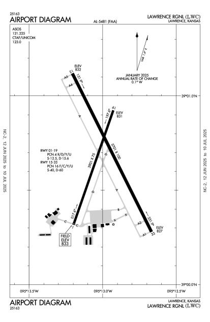
Runway 15/33
Dimensions:
5,701 × 100 ft
(1,738 × 30 m)
(1,738 × 30 m)
Weight Bearing Cap:
Single wheel: 40,000 lbs
Double wheel: 60,000 lbs
Double wheel: 60,000 lbs
Surface:
asphalt, no surface treatment, in excellent condition
Runway Edge Lights:
Medium
Comments:
n/a
| Designator: | 15 | 33 |
| Elevation: | 831.5 ft | 827.1 ft |
| Heading: | 149° magnetic 153° true | 329° magnetic 333° true |
| Gradient: | 0.08% down | 0.08% up |
| Traffic Pattern: | Not provided. Assume LEFT traffic pattern | Not provided. Assume LEFT traffic pattern |
| Markings: | non-precision, in Good condition | precision, in Good condition |
| Approach Lighting: |
|
|
| Displaced Threshold: | n/a | n/a |
| ILS/LOC: | n/a | ILS |
| Obstructions: | n/a | Trees, 531 ft Left ft of center, 49 ft high, 2,462 ft from end, 46:1 clearance slope |
| Comments: | n/a | n/a |
Runway 01/19
Dimensions:
3,901 × 75 ft
(1,189 × 23 m)
(1,189 × 23 m)
Weight Bearing Cap:
Single wheel: 13,000 lbs
Double wheel: 16,000 lbs
Double wheel: 16,000 lbs
Surface:
concrete, no surface treatment, in good condition
Runway Edge Lights:
Medium
Comments:
n/a
| Designator: | 01 | 19 |
| Elevation: | 832.5 ft | 831.1 ft |
| Heading: | 015° magnetic 019° true | 195° magnetic 199° true |
| Gradient: | 0.04% down | 0.04% up |
| Traffic Pattern: | Left Pattern | Left Pattern |
| Markings: | non-precision, in Fair condition | non-precision, in Fair condition |
| Approach Lighting: |
|
|
| Displaced Threshold: | n/a | n/a |
| ILS/LOC: | n/a | n/a |
| Obstructions: | n/a | n/a |
| Comments: | n/a | n/a |
TFRs
Location: LWC
Please verify all content below using the FAA TFR Search Site or with a flight briefer.
TFR count: 0
NOTAMs
Location: LWC
Please verify all content below using the FAA NOTAM Search Site or with a flight briefer.
NOTAM count: 3
| Number: | Start Date: (UTC) | End Date: (UTC) | Condition: |
|---|---|---|---|
| 5/3285 | 03/14/2025 1535 | IAP LAWRENCE RGNL, LAWRENCE, KS.
RNAV (GPS) RWY 33, AMDT 1A...
DISREGARD PROFILE NOTE: VGSI AND RNAV GLIDEPA… | |
| 5/3831 | 04/08/2025 1821 | IAP LAWRENCE RGNL, LAWRENCE, KS.
ILS OR LOC RWY 33, AMDT 1C...
DISREGARD PROFILE NOTE: VGSI AND ILS GLIDEPAT… | |
| 4/9939 | 07/30/2024 1336 | IAP LAWRENCE RGNL, LAWRENCE, KS.
RNAV (GPS) RWY 15, ORIG-D...
LNAV MDA 1360/HAT 529 ALL CATS.
2407301336-260… | |
Additional Remarks
Noise Abatement
Instrument Procedures
Data Cycle:
Operations & More Information
Lat/Long:
- 39.01111, -95.21647
- 39° 0′ 40.0″ N, 95° 12′ 59.3″ W
- 39° 0.667′ N, 95° 12.988′ W
ARTCC:
Kansas City (ZKC)
App/Depart Control Facility:
Unknown
Chart:
NACO: Kansas City Sectional
FSS:
Wichita (ICT)
1-800-WX-BRIEF
1-800-WX-BRIEF
Wind Indicator:
Lighted
Mag Var:
04E (2005)
NOTAM Facility:
Seg Circle:
Yes
Beacon:
Present
Lighting:
Pilot Activated Lighting:
- medium intensity: 3 clicks in 5 secs
AM
Actvt MALSR Rwy 33; REIL Rwy 01, 15, & 19; PAPI Rwy 01, 19, 15 & 33; MIRL Rwy 01/19 & 15/33 - CTAF.
FAA
Pattern Altitude:
No data provided. Assume 1000 AGL.
Special Operations:
Communications Card
| Type: | Frequency / Phone: | Sector / Comments: | Call Sign: |
|---|---|---|---|
| ASOS | 121.225T (785) 749-1309 | ||
| CTAF | 123.0 | ||
| UNICOM | 123.0 |
Navaids
Services
Fuel:
100LL Low-Lead, Jet A
AM
Engine Repair:
Major
AM
Airframe Repair:
Major
AM
Bottled Oxygen:
High
AM
Bulk Oxygen:
High
AM
Customs:
None
Transportation:
Courtesy Transportation
AM
Activities:
Intensive Flight Training
AM
Camping On Field:
None Reported
Aircraft & Activity
Webcams
METARs
TAFs
Contact Addresses
Airport Manager
Scott Wagner
Lawrence, KS 66044
(785) 832-3467 (Office)
Owner
City of Lawrence
Lawrence, KS 66044
(785) 832-3467 (Office)
Remarks:
Aft Hrs Aprt Manager CTC - 785-813-5765
FAA
Airport Reviews
Overall:
No ratings | 1 review
Runways and Taxiways:No ratings
Markings and Signage:No ratings
Ground Transportation:No ratings
Sort By:
- 9/9/15JEFF S.Really nice facility and friendly FBO. Service was great, and the courtesy car (2 hr limit though) made getting into town for lunch easy. Watch out for the standing Stadium TFR on KU Home Game days - it backs right up to the western edge of the airpo…