FAA Information Effective: Jun 12, 2025
All information is provided from the FAA unless otherwise noted.
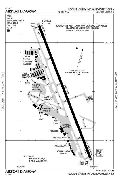
(KMFR) Rogue Valley International/Medford Airport
1 rating | 1 review
Overview
Attendance:
Attended
Year-round, 7 Days a Week,0500-2400
FAA
Runways:
14/32
Runway length: 8,800 ft (2,682 m)
Elevation:
1,335 ft (Surveyed)
Tower:
Apch/Dep Ctl Svc Prvdd By Seattle Artcc (Zse) On Freq 124.85/306.3 (King Mountain Rcag) When Cascade Apch Ctl (Eug) Clsd. Primary Apch/Dep Hrs 0600-2330.
FAA
Tower Hrs: 0600-2100
FAA
Airspace:
CLASS D SVC 0600-2100; OTHER TIMES CLASS E
FAA
Fees:
Hangar, Landing, Overnight, Ramp, Other
Click FBO link(s) below for details:
Million Air Medford
Click FBO link(s) below for details:
FBO Fee Details:
Jet Center MFRMillion Air Medford
Timezone:
PDT (UTC-07:00)
Sunrise-Sunset:
5:35 am - 8:52 pm
Evening-Morning Civil Twilight:
9:27 pm
(Today)
(Today)
-
5:00 am
(Tomorrow)
(Tomorrow)
Minimum Fuel Prices:
$7.33
100LL (full)
$5.58
100LL (self)
$5.83
Jet-A (full)
$5.93
Jet-A-Premix/Prist (full)
Runway
Satellite
Sectional
FBOs
Submit New FBO
Jet Center MFR
No ratings | Be the first to review this business
Services Offered:
Maintenance
Car Rental
Sales
Location:
On field: NW
Phone:
(541) 770-5314
Freq. Monitored:
ASRI: 131.75
Fees:
Landing, Overnight, Ramp, Other
Million Air Medford
1 rating | 2 reviews
Services Offered:
Car Rental
$7.33 | 100LL | full
$5.58 | 100LL | self
$5.83 | Jet-A | full
$5.93 | Jet-A-Premix/Prist | full
Location:
On field: CTR
Phone:
(541) 842-2254
Freq. Monitored:
ASRI: 130.62
Fees:
Hangar, Landing, Other
Flight Training
Submit New Flight School
Other businesses
Submit New Business
AOPA Travel Discounts 
FlightBridge is the ultimate all-in-one travel booking platform built for the general aviation community. AOPA Members receive free access to FlightBridge with AOPA discounted rates automatically applied. Members save an average of 30% on hotel bookings! Learn more about FlightBridge HERE.
Local Food/Lodging/Activities
Local Attractions
Local Activities
Restaurants
Hotels and Lodging
Travel Discounts
(541) 776-7222
(541) 499-6975
MFR
KC-97 Fuel Tanker
Sky House Bar & Grill
Flying Clubs
Submit New Flying Club
Runway 14/32
Dimensions:
8,800 × 150 ft
(2,682 × 46 m)
(2,682 × 46 m)
Weight Bearing Cap:
Single wheel: 75,000 lbs
Double wheel: 200,000 lbs
Double tandem: 400,000 lbs
Double wheel: 200,000 lbs
Double tandem: 400,000 lbs
Surface:
asphalt, grooved, in good condition
Runway Edge Lights:
High
Comments:
Pcr Value: 1110/F/D/X/T
FAA
| Designator: | 14 | 32 |
| Elevation: | 1,294 ft | 1,335.3 ft |
| Heading: | 142° magnetic 158° true | 322° magnetic 338° true |
| Gradient: | 0.47% up | 0.47% down |
| Traffic Pattern: | Left Pattern | Left Pattern |
| Markings: | precision, in Good condition | non-precision, in Good condition |
| Approach Lighting: |
|
|
| Displaced Threshold: | n/a | n/a |
| ILS/LOC: | ILS/DME | n/a |
| Obstructions: | n/a | n/a |
| Comments: | n/a | Papi Rwy 32 Does not Prvd Obs Clnc Byd 6.5 Nm Fm Thr. FAA |
TFRs
Location: MFR
Please verify all content below using the FAA TFR Search Site or with a flight briefer.
TFR count: 0
NOTAMs
Location: MFR
Please verify all content below using the FAA NOTAM Search Site or with a flight briefer.
NOTAM count: 4
| Number: | Start Date: (UTC) | End Date: (UTC) | Condition: |
|---|---|---|---|
| 05/007 | 05/11/2025 0724 | 06/25/2025 0715 | OBST TOWER LGT (ASR 1033916) 421712.40N1230019.50W (7.8NM SW MFR) 2912.7FT (299.9FT AGL) U/S |
| 5/2373 | 04/04/2025 1627 | IAP ROGUE VALLEY INTL/MEDFORD, MEDFORD, OR.
LOC/DME BC-B, AMDT 7A...
PROCEDURE NA.
LOCALIZER BACKCOURSE UNUS… | |
| 05/032 | 05/09/2024 1424 | NAV ILS RWY 14 DME NOT MNT | |
| 06/030 | 06/17/2025 1600 | 06/18/2025 2300 | AIRSPACE UAS WI AN AREA DEFINED AS 1NM RADIUS OF 422110N1225608W (3.2NM SW MFR) SFC-400FT AGL DLY 1600-2300 |
Additional Remarks
Cold Temperature Airport. Altitude Correction Required At or Below -3C.
Source:
FAA
Federal Aviation Administration
For Cd If Una to CTC on FSS Freq, CTC Seattle ARTCC at 253-351-3694.
Source:
FAA
Federal Aviation Administration
Fuel Aft Hr - 541-842-2254.
Source:
FAA
Federal Aviation Administration
Pilots Conducting Efvs Ops; be Aware Led Als in Use Rwy 14.
Source:
FAA
Federal Aviation Administration
Sfc Cond Unmnt 2400-0400.
Source:
FAA
Federal Aviation Administration
Trml Apron Clsd Excp Sked Acr & Ppr.
Source:
FAA
Federal Aviation Administration
Tsnt Tie Down & Hngr Avblty - FBO.
Source:
FAA
Federal Aviation Administration
Waterfowl In vicinity of Airport Nov-May.
Source:
FAA
Federal Aviation Administration
Ppr for Unsked Operations Gtr Than 30 Pax Seats - 541-776-7228.
Source:
FAA
Federal Aviation Administration
Noise Abatement
Instrument Procedures
Data Cycle:
Operations & More Information
Lat/Long:
- 42.37496, -122.87329
- 42° 22′ 29.9″ N, 122° 52′ 23.8″ W
- 42° 22.498′ N, 122° 52.397′ W
ARTCC:
Seattle (ZSE)
App/Depart Control Facility:
EUG
Chart:
NACO: Klamath Falls Sectional
FSS:
Mc Minnville (MMV)
1-800-WX-BRIEF
1-800-WX-BRIEF
Wind Indicator:
Lighted
Mag Var:
16E (2010)
NOTAM Facility:
Seg Circle:
Yes
Beacon:
Present
Lighting:
Pilot Activated Lighting:
- low intensity: 3 clicks in 7 secs
- medium intensity: 5 clicks in 7 secs
- high intensity: 7 clicks in 7 secs
AM
Actvt MALSR Rwy 14; REIL Rwy 32; Tdz Rwy 14; Cntrln Lgts Rwy 14/32; PAPI Rwy 14 & 32; HIRL Rwy 14/32; Twy Lgts - CTAF.
FAA
Pattern Altitude:
969 Ft AGL for Prop Acft; 1469 Ft AGL for Turbo Acft.
FAA
TPA: 969 Ft AGL
FAA
Special Operations:
Communications Card
| Type: | Frequency / Phone: | Sector / Comments: | Call Sign: |
|---|---|---|---|
| Approach/Departure | 124.3 | Cascade | |
| ASOS | 127.25T (541) 204-0136 | Medford | |
| ATIS | 127.25 | Medford | |
| CTAF | 119.4 | Medford | |
| Emergency | 121.5 | Medford | |
| Ground Control | 121.8 | Medford | |
| Tower | 119.4 | Medford | |
| UNICOM | 122.95 | Medford |
Navaids
Services
Fuel:
100LL Low-Lead, Jet A
AM
Engine Repair:
Major
AM
Airframe Repair:
Major
AM
Bottled Oxygen:
High
AM
Bulk Oxygen:
None
Customs:
None
Transportation:
Courtesy Transportation
AM
Activities:
Airline Services
AM
Camping On Field:
None Reported
Aircraft & Activity
Webcams
METARs
TAFs
Contact Addresses
Airport Manager
Amber Judd
Medford, OR 97504
(541) 776-7222 (Office)
Owner
Jackson County
Medford, OR 97501
(541) 774-6035 (Office)
Airport Reviews
Overall:
1 rating | 1 review
Runways and Taxiways:No ratings
Markings and Signage:No ratings
Ground Transportation:No ratings
Sort By:
- 7/1/19Shannon P.Flew in for a meeting in April. 3 months later received a $50 invoice for a landing fee!!! The FBO never informed us of a landing fee, did not see anything on Foreflight, this AOPA info page and a few others. After receipt of the invoice and 20 mi…