FAA Information Effective: Jul 10, 2025
All information is provided from the FAA unless otherwise noted.
(KMRC) Maury County Regional Airport
No ratings | No reviews
Overview
Attendance:
Attended
Year-round, 7 Days a Week,0700-1700
FAA
Elevation:
681 ft (Surveyed)
Tower:
No
Airspace:
Unknown
Fees:
Ramp, Other
Click FBO link(s) below for details:
Click FBO link(s) below for details:
FBO Fee Details:
Maury County Regional Airport AuthorityTimezone:
CDT (UTC-05:00)
Sunrise-Sunset:
5:50 am - 8:01 pm
Evening-Morning Civil Twilight:
8:30 pm
(Today)
(Today)
-
5:22 am
(Tomorrow)
(Tomorrow)
Minimum Fuel Prices:
$5.82
100LL (full)
$5.35
Jet-A-Premix/Prist (full)
Runway
Satellite
Sectional
FBOs
Submit New FBO
Maury County Regional Airport Authority
No ratings | Be the first to review this business
Services Offered:
Car Rental
$5.82 | 100LL | full
$5.35 | Jet-A-Premix/Prist | full
Location:
On field: CTR
Phone:
(931) 379-5511
Freq. Monitored:
UNICOM: 122.8
Fees:
Ramp, Other
Flight Training
Submit New Flight School
Other businesses
Submit New Business
AOPA Travel Discounts 
FlightBridge is the ultimate all-in-one travel booking platform built for the general aviation community. AOPA Members receive free access to FlightBridge with AOPA discounted rates automatically applied. Members save an average of 30% on hotel bookings! Learn more about FlightBridge HERE.
Local Food/Lodging/Activities
Local Attractions
Local Activities
Restaurants
Hotels and Lodging
Travel Discounts
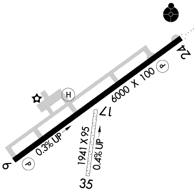
Runway 06/24
Dimensions:
6,000 × 100 ft
(1,829 × 30 m)
(1,829 × 30 m)
Weight Bearing Cap:
Single wheel: 34,000 lbs
Double wheel: 50,000 lbs
Double tandem: 70,000 lbs
Double wheel: 50,000 lbs
Double tandem: 70,000 lbs
Surface:
asphalt, no surface treatment, in good condition
Runway Edge Lights:
Medium
Comments:
n/a
| Designator: | 06 | 24 |
| Elevation: | 664 ft | 681.1 ft |
| Heading: | 055° magnetic 054° true | 235° magnetic 234° true |
| Gradient: | 0.29% up | 0.29% down |
| Traffic Pattern: | Left Pattern | Left Pattern |
| Markings: | non-precision, in Fair condition | non-precision, in Fair condition |
| Approach Lighting: |
|
|
| Displaced Threshold: | n/a | n/a |
| ILS/LOC: | n/a | SDF |
| Obstructions: | Tree, 206 ft Left ft of center, 49 ft high, 1,296 ft from end, 22:1 clearance slope | Tree, 348 ft Left ft of center, 52 ft high, 1,270 ft from end, 20:1 clearance slope |
| Comments: | n/a | n/a |
Runway 17/35
Dimensions:
1,941 × 95 ft
(592 × 29 m)
(592 × 29 m)
Weight Bearing Cap:
n/a
Surface:
turf, grass, sod, no surface treatment, in good condition
Runway Edge Lights:
n/a
Comments:
n/a
| Designator: | 17 | 35 |
| Elevation: | 666.7 ft | 659.2 ft |
| Heading: | 188° magnetic 187° true | 008° magnetic 007° true |
| Gradient: | 0.39% down | 0.39% up |
| Traffic Pattern: | Left Pattern | Left Pattern |
| Markings: | n/a | n/a |
| Approach Lighting: | n/a | n/a |
| Displaced Threshold: | n/a | n/a |
| ILS/LOC: | n/a | n/a |
| Obstructions: | Pole, 194 ft Right ft of center, 81 ft high, 1,379 ft from end, 17:1 clearance slope | n/a |
| Comments: | n/a | n/a |
Helipad H1
Dimensions:
25 × 25 ft
(8 × 8 m)
(8 × 8 m)
Weight Bearing Cap:
n/a
Surface:
concrete, no surface treatment, in fair condition
Runway Edge Lights:
n/a
Comments:
n/a
| Designator: | H1 |
| Elevation: | 665 ft |
| Markings: | basic, in Fair condition |
| Obstructions: | n/a |
| Comments: | n/a |
TFRs
Location: MRC
Please verify all content below using the FAA TFR Search Site or with a flight briefer.
TFR count: 0
NOTAMs
Location: MRC
Please verify all content below using the FAA NOTAM Search Site or with a flight briefer.
NOTAM count: 7
| Number: | Start Date: (UTC) | End Date: (UTC) | Condition: |
|---|---|---|---|
| 07/356 | 07/22/2025 1700 | 07/23/2025 2200 | AIRSPACE UAS WI AN AREA DEFINED AS 2NM RADIUS OF MRC SFC-75FT AGL |
| 5/7291 | 04/16/2025 1405 | IAP MAURY COUNTY RGNL, COLUMBIA/MOUNT PLEASANT, TN.
RNAV (GPS) RWY 24, ORIG-B...
LNAV CATS A/B VISIBILITY 1 … | |
| 5/4924 | 04/10/2025 1755 | ODP MAURY COUNTY RGNL, COLUMBIA/MOUNT PLEASANT, TN.
TAKEOFF MINIMUMS AND (OBSTACLE) DEPARTURE PROCEDURES AMD… | |
| 4/9854 | 05/28/2024 2135 | IAP MAURY COUNTY RGNL, COLUMBIA/MOUNT PLEASANT, TN.
RNAV (GPS) RWY 24, ORIG-B...
DISREGARD NOTE: VGSI AND RN… | |
| 5/7288 | 04/16/2025 1343 | IAP MAURY COUNTY RGNL, COLUMBIA/MOUNT PLEASANT, TN.
RNAV (GPS) RWY 6, ORIG-A...
LNAV CAT C VISIBILITY 1 7/8 … | |
| 07/329 | 07/19/2025 0047 | 09/02/2025 0047 | OBST TOWER LGT (ASR 1225154) 353211.70N0871309.90W (2.3NM WSW MRC) 1041.7FT (194.9FT AGL) U/S |
| 4/2471 | 09/30/2024 1934 | IAP MAURY COUNTY RGNL, COLUMBIA/MOUNT PLEASANT, TN.
RNAV (GPS) RWY 6, ORIG-A...
DISREGARD PROFILE NOTE: VGSI… | |
Additional Remarks
330 Ft Lgtd Ant 1.9 Nm Sw.
Source:
FAA
Federal Aviation Administration
For Clearance Delivery Contact Memphis ARTCC at 901-368-8453/8449.
Source:
FAA
Federal Aviation Administration
Noise Abatement
Instrument Procedures
Data Cycle:
Operations & More Information
Lat/Long:
- 35.55434, -87.17914
- 35° 33′ 15.6″ N, 87° 10′ 44.9″ W
- 35° 33.260′ N, 87° 10.748′ W
ARTCC:
Memphis (ZME)
App/Depart Control Facility:
Unknown
Chart:
NACO: Atlanta Sectional
FSS:
Jackson (MKL)
1-800-WX-BRIEF
1-800-WX-BRIEF
Wind Indicator:
Lighted
Mag Var:
01W (1990)
NOTAM Facility:
Seg Circle:
Yes
Beacon:
Present
Lighting:
Actvt ODALS Rwy 24; REIL Rwy 24 - CTAF.
FAA
Pattern Altitude:
No data provided. Assume 1000 AGL.
Special Operations:
Helicopter Ops
FAA
Communications Card
| Type: | Frequency / Phone: | Sector / Comments: | Call Sign: |
|---|---|---|---|
| AWOS-3 | 128.625T (931) 379-0844 | ||
| Clearance Delivery Phone | (901) 368-8453 | Memphis ARTCC | |
| CTAF | 122.8 | ||
| UNICOM | 122.8 |
Navaids
Services
Fuel:
100LL Low-Lead
AM
Engine Repair:
Minor
AM
Airframe Repair:
Minor
AM
Bottled Oxygen:
None
Bulk Oxygen:
None
Customs:
None
Transportation:
Courtesy Transportation
AM
Activities:
None Reported
Camping On Field:
None Reported
Aircraft & Activity
Webcams
METARs
METARs from this airport:
METARs from nearby reporting stations:
TAFs
TAFs from nearby airports:
KBNA TAF
41 nm NE
Issued:
11:20 PM GMT
(an hour ago)
Today 12:00 AM - 3:00 PM GMT
Vis:
6+
SM
Wind:
@
4
KT
Cld:
- Scattered clouds 25000' AGL
Wx:
N/A
Today 3:00 PM - Tomorrow 12:00 AM GMT
Vis:
6+
SM
Wind:
@
5
KT
Cld:
- Scattered clouds 5000' AGL
Wx:
N/A
KMQY TAF
42 nm NE
Issued:
11:20 PM GMT
(an hour ago)
Today 12:00 AM - 3:00 PM GMT
Vis:
6+
SM
Wind:
VRB
@
3
KT
Cld:
- Scattered clouds 25000' AGL
Wx:
N/A
Today 8:00 AM - 12:00 PM GMT
TEMPO
Vis:
4
SM
Wind:
VRB
@
3
KT
Cld:
- Scattered clouds 25000' AGL
Wx:
Mist
Today 3:00 PM - Tomorrow 12:00 AM GMT
Vis:
6+
SM
Wind:
@
5
KT
Cld:
- Scattered clouds 5000' AGL
Wx:
N/A
Contact Addresses
Airport Manager
Paul Turner
Mt Pleasant, TN 38474
(931) 379-5511 (Office)
Owner
Maury County Region Airport Authority
Mt Pleasant, TN 38474
(931) 379-5511 (Office)
Airport Reviews
Nearby Events
- No nearby events found.