FAA Information Effective: Jul 10, 2025
All information is provided from the FAA unless otherwise noted.
(KRYM) Ray S Miller Army Airfield
No ratings | No reviews
Camp Ripley, MN
(320) 616-2780
Overview
Attendance:
Attended
Year-round,Mon-Fri/1300-0500Z
FAA
Elevation:
1,150 ft (Estimated)
Tower:
Apch/Dep Svc Prvdd By Minneapolis Artcc On Freqs 118.05/239.0 (Brainerd Rcag).
FAA
Mil Ops Hrs: 0800-1630 JAN-MAR; 0800-1900 MAY AUG
FAA
Tower Hrs: 1300-0445Z++ MON-THU, 1400-2200Z++ FRI, CLSD HOL.
FAA
Airspace:
CLASS D SVC 1300-0445Z++ MON-THU, 1400-2200Z++ FRI, CLSD HOL; OTHER TIMES CLASS E
FAA
Fees:
None
Timezone:
CDT (UTC-05:00)
Sunrise-Sunset:
5:52 am - 8:57 pm
Evening-Morning Civil Twilight:
9:32 pm
(Today)
(Today)
-
5:18 am
(Tomorrow)
(Tomorrow)
Runway
Satellite
Sectional
FBOs and Other Businesses
Submit New FBO
AOPA Travel Discounts 
FlightBridge is the ultimate all-in-one travel booking platform built for the general aviation community. AOPA Members receive free access to FlightBridge with AOPA discounted rates automatically applied. Members save an average of 30% on hotel bookings! Learn more about FlightBridge HERE.
Local Food/Lodging/Activities
Local Attractions
Local Activities
Restaurants
Hotels and Lodging
Travel Discounts
Flying Clubs
Submit New Flying Club
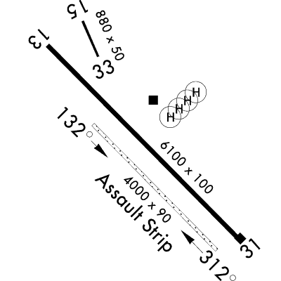
Runway 13/31
Dimensions:
6,100 × 100 ft
(1,859 × 30 m)
(1,859 × 30 m)
Weight Bearing Cap:
n/a
Surface:
asphalt, no surface treatment, condition not reported
Runway Edge Lights:
High
Comments:
n/a
| Designator: | 13 | 31 |
| Elevation: | 1,149.5 ft | 1,143.4 ft |
| Heading: | n/a | n/a |
| Gradient: | 0.1% down | 0.1% up |
| Traffic Pattern: | Not provided. Assume LEFT traffic pattern | Not provided. Assume LEFT traffic pattern |
| Markings: | precision, in Good condition | precision, in Good condition |
| Approach Lighting: | n/a |
|
| Displaced Threshold: | n/a | n/a |
| ILS/LOC: | n/a | ILS/DME |
| Obstructions: | n/a | n/a |
| Comments: | n/a | n/a |
Runway 132/312
Dimensions:
4,000 × 90 ft
(1,219 × 27 m)
(1,219 × 27 m)
Weight Bearing Cap:
n/a
Surface:
gravel, no surface treatment, condition not reported
Runway Edge Lights:
High
Comments:
Assault Strip.
FAA
| Designator: | 132 | 312 |
| Elevation: | 1,149.4 ft | 1,145.6 ft |
| Heading: | n/a | n/a |
| Gradient: | 0.1% down | 0.1% up |
| Traffic Pattern: | Not provided. Assume LEFT traffic pattern | Not provided. Assume LEFT traffic pattern |
| Markings: | n/a | n/a |
| Approach Lighting: |
|
|
| Displaced Threshold: | n/a | n/a |
| ILS/LOC: | n/a | n/a |
| Obstructions: | n/a | n/a |
| Comments: | n/a | n/a |
Runway 15/33
Dimensions:
880 × 50 ft
(268 × 15 m)
(268 × 15 m)
Weight Bearing Cap:
n/a
Surface:
asphalt, no surface treatment, condition not reported
Runway Edge Lights:
n/a
Comments:
n/a
| Designator: | 15 | 33 |
| Elevation: | 1,135 ft | 1,134 ft |
| Heading: | n/a | n/a |
| Gradient: | 0.11% down | 0.11% up |
| Traffic Pattern: | Not provided. Assume LEFT traffic pattern | Not provided. Assume LEFT traffic pattern |
| Markings: | n/a | n/a |
| Approach Lighting: | n/a | n/a |
| Displaced Threshold: | n/a | n/a |
| ILS/LOC: | n/a | n/a |
| Obstructions: | n/a | n/a |
| Comments: | n/a | n/a |
TFRs
Location: RYM
Please verify all content below using the FAA TFR Search Site or with a flight briefer.
TFR count: 0
NOTAMs
Location: RYM
Please verify all content below using the FAA NOTAM Search Site or with a flight briefer.
NOTAM count: 10 (Partial list shown. Expand to see full list HERE.)
| Number: | Start Date: (UTC) | End Date: (UTC) | Condition: |
|---|---|---|---|
| V0280/25 | 07/16/2025 2309 | 08/01/2025 2359 | [US DOD PROCEDURAL NOTAM] INSTRUMENT APPROACH PROCEDURE CHANGED ILS OR LOC RWY 31 MISSED APPROACH: CLIMB TO … |
| 06/30/2025 1256 | 09/24/2025 1800 | OBST GCA EQUIPMENT 310 FT EAST RWY 31R MIDFIELD | |
| M0439/25 | 07/28/2025 1200 | 07/31/2025 1800 | TOWER CLSD CLASS D SERVICE UNAVAILABLE CLASS E IN EFFECT |
| M0438/25 | 07/25/2025 1433 | 07/28/2025 1433 | M0438/25 NOTAMC M0429/25
A) KRYM |
| M0434/25 | 07/25/2025 1100 | 07/25/2025 1500 | OBSTACLE RIG 460516N0942049W
(0.5NM EAST SOUTHEAST KRYM) UNKNOWN MSL
(80FT AGL) DAYLIGHT HOURS ONLY |
| M0425/25 | 07/21/2025 1206 | 10/02/2025 2100 | NAVAID RYM NDB UNSERVICEABLE |
| 07/26/2025 1300 | 07/29/2025 0100 | UNMANNED AIRCRAFT IN APP/DEP PATH 1NM NW DEP END RWY 31 SFC-400' AGL (TA10, CACTF) | |
| M0437/25 | 07/25/2025 1341 | 07/25/2025 2300 | TOWER CLSD CLASS D SERVICE UNAVAILABLE CLASS E IN EFFECT |
Additional Remarks
Caution: Ocnl Uas Operations - Ck Notam.
Source:
FAA
Federal Aviation Administration
Caution: Rwy Edge Lgt Psn 25 Ft Fm Usbl Rwy Sfc.
Source:
FAA
Federal Aviation Administration
Caution: Wildlife Haz.
Source:
FAA
Federal Aviation Administration
Fuel: F24
Source:
FAA
Federal Aviation Administration
Misc: for Winter Rwy Cond - C320-616-2779.
Source:
FAA
Federal Aviation Administration
Misc: Ltd Fixed Wing Tsnt Prkg.
Source:
FAA
Federal Aviation Administration
Misc: Prior Permission Required for Ltd Avbl Svc on Wkend.
Source:
FAA
Federal Aviation Administration
Misc: Prk Area Cap Designed for 3 C130 Acft Simultaneously. Assault Strip Mrk Cntr 3500 Ft of Rwy 750 Ft Ovrn Both Ends. CTC Base Operations for Assault Strip Cond.
Source:
FAA
Federal Aviation Administration
Noise Abatement Proc in Efct.
Source:
FAA
Federal Aviation Administration
Opr Agency Arng.
Source:
FAA
Federal Aviation Administration
Rstd: Prior Permission Required - Base Operations Dsn 871-2779; C320-616-2779; Tower C320-632-7751.
Source:
FAA
Federal Aviation Administration
Rstd; Rwy 15/33 for Unmanned Acft Use Only.
Source:
FAA
Federal Aviation Administration
RESTRICTED. MILITARY AIRPORT. PRIOR PERMISSION REQUIRED. CONTACT BASE OPS MANAGER 320/632-6631
Source:
AM
Airport Manager
Noise Abatement
Instrument Procedures
Data Cycle:
Operations & More Information
Lat/Long:
- 46.09066, -94.36049
- 46° 5′ 26.4″ N, 94° 21′ 37.7″ W
- 46° 5.439′ N, 94° 21.629′ W
ARTCC:
Minneapolis (ZMP)
App/Depart Control Facility:
Unknown
Chart:
NACO: Twin Cities Sectional
FSS:
Princeton (PNM)
1-800-WX-BRIEF
1-800-WX-BRIEF
Wind Indicator:
No
Mag Var:
03E (1995)
NOTAM Facility:
Seg Circle:
No
Beacon:
Not Present
Lighting:
Actvt Malsf Rwy 31; HIRL Rwy 13/31 & 132/312; REIL Rwy 132 & 312 - 126.2. Malsf Rwy 31 & HIRL Rwy 13/31 Preset to Low Intst; Incr Intst - 126.2.
FAA
Pattern Altitude:
No data provided. Assume 1000 AGL.
Special Operations:
Communications Card
| Type: | Frequency / Phone: | Sector / Comments: | Call Sign: |
|---|---|---|---|
| AWOS-3 | 121.575T | Miller | |
| Clearance Delivery | 126.2 | Miller | |
| OPS | 41.5 | MILLER | Miller |
| RANGE CTL | 36.1 | Miller | |
| RANGE CTL | 40.4 | Miller | |
| Tower | 126.2 | Miller |
Navaids
Services
Aircraft & Activity
Webcams
METARs
TAFs
Contact Addresses
Airport Manager
Michael Guidry
(320) 616-2780 (Office)
Owner
US Army Aeronautical Services Agency