FAA Information Effective: Jun 12, 2025
All information is provided from the FAA unless otherwise noted.
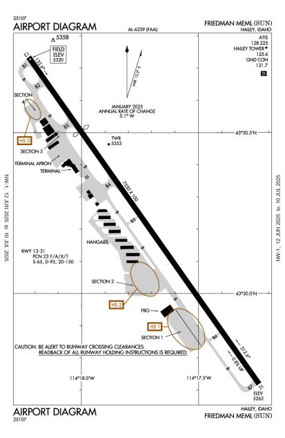
(KSUN) Friedman Memorial Airport
No ratings | 1 review
Overview
Attendance:
Attended
Year-round, 7 Days a Week,0700-2300
FAA
Runways:
13/31
Runway length: 7,550 ft (2,301 m)
Elevation:
5,320 ft (Surveyed)
Tower:
Apch/Dep Ctl Svc Prvdd By Salt Lake Artcc (Zlc) On Freqs 118.05/363.0 (Burley Rcag).
FAA
Blaine County Arpt Cmsn Contr.
FAA
Freq 121.5 Not Avbl At Twr.
FAA
Tower Hrs: 0700-2300
FAA
Airspace:
CLASS D SVC 0700-2300; OTHER TIMES CLASS E
FAA
Fees:
Landing, Overnight, Parking, Other
Click FBO link(s) below for details:
Click FBO link(s) below for details:
FBO Fee Details:
Atlantic AviationTimezone:
MDT (UTC-06:00)
Sunrise-Sunset:
5:57 am - 9:22 pm
Evening-Morning Civil Twilight:
9:58 pm
(Today)
(Today)
-
5:21 am
(Tomorrow)
(Tomorrow)
Minimum Fuel Prices:
$8.21
100LL (full)
$6.04
100LL (self)
$9.14
Jet-A (full)
Runway
Satellite
Sectional
FBOs
Submit New FBO
Atlantic Aviation
2 ratings | 2 reviews
Services Offered:
Car Rental
$8.21 | 100LL | full
$6.04 | 100LL | self
$9.14 | Jet-A | full
Location:
On field: S
Phone:
(208) 788-9511
Freq. Monitored:
UNICOM: 122.95
Fees:
Landing, Overnight, Parking, Other
Flight Training
Submit New Flight School
Other businesses
Submit New Business
AOPA Travel Discounts 
FlightBridge is the ultimate all-in-one travel booking platform built for the general aviation community. AOPA Members receive free access to FlightBridge with AOPA discounted rates automatically applied. Members save an average of 30% on hotel bookings! Learn more about FlightBridge HERE.
Local Food/Lodging/Activities
Local Attractions
Local Activities
Restaurants
Hotels and Lodging
Travel Discounts
Flying Clubs
Submit New Flying Club
Runway 13/31
Dimensions:
7,550 × 100 ft
(2,301 × 30 m)
(2,301 × 30 m)
Weight Bearing Cap:
Single wheel: 65,000 lbs
Double wheel: 95,000 lbs
Double tandem: 150,000 lbs
Double wheel: 95,000 lbs
Double tandem: 150,000 lbs
Surface:
asphalt, grooved, in good condition
Runway Edge Lights:
High
Comments:
When Air Traffic Control Tower Clsd Lnd Rwy 31; Tkof Rwy 13; Opdt in Pat. Air Traffic Control Tower 275 Ft E of Cntrln.
FAA
| Designator: | 13 | 31 |
| Elevation: | 5,319.5 ft | 5,261.8 ft |
| Heading: | 132° magnetic 145° true | 312° magnetic 325° true |
| Gradient: | 0.76% down | 0.76% up |
| Traffic Pattern: | Left Pattern | Left Pattern |
| Markings: | non-precision, in Good condition | precision, in Fair condition |
| Approach Lighting: | n/a |
|
| Displaced Threshold: | 1,701 ft | n/a |
| ILS/LOC: | n/a | n/a |
| Obstructions: | Road, 190 ft Left ft of center, 17 ft high, 200 ft from end | Tree, 600 ft Left ft of center, 64 ft high, 1,600 ft from end, 21:1 clearance slope |
| Comments: | +17 Ft Road 450 Ft Fm Thr 250 Ft L; +15 Ft Pipes 500 Ft Fm Thr 180 Ft R; +7 Ft Fence 550 Ft Fm Thr 180 Ft L; +17 Ft Road 550 Ft Fm Thr 190 Ft L. FAA Road 65:1 to Dthr; Prkd Acft 0-225 Ft L 0:1 to Dthr. FAA | n/a |
TFRs
Location: SUN
Please verify all content below using the FAA TFR Search Site or with a flight briefer.
TFR count: 0
NOTAMs
Location: SUN
Please verify all content below using the FAA NOTAM Search Site or with a flight briefer.
NOTAM count: 4
| Number: | Start Date: (UTC) | End Date: (UTC) | Condition: |
|---|---|---|---|
| 03/064 | 03/22/2025 0334 | COM REMOTE COM OUTLET 122.4 U/S | |
| 03/056 | 03/19/2025 1800 | OBST TREE (ASN UNKNOWN) 433050N1141819W (0.095NM NNW
APCH END RWY 13) UNKNOWN (100FT AGL) NOT LGTD | |
| 06/012 | 06/19/2025 1400 | 06/19/2025 1800 | OBST CRANE (ASN UNKNOWN) 433055N1141823W (.27NM N APCH END RWY 13)
UNKNOWN (85FT AGL) FLAGGED |
| 5/3801 | 03/17/2025 1442 | IAP FRIEDMAN MEML, HAILEY, ID.
RNAV (GPS) X RWY 31, ORIG...
RNAV (GPS) Y RWY 31, ORIG...
DISREGARD PLANVIEW … | |
Additional Remarks
Acr Ltd Prkg Avbl.
Source:
FAA
Federal Aviation Administration
All Sfcs Avbl to Acrs.
Source:
FAA
Federal Aviation Administration
Apch Rwy 31 Alg E Side of Valley; Dep Rwy 13 Alg W Side of Valley; with Lndg Lgt On; Opdt.
Source:
FAA
Federal Aviation Administration
Apu Operations Ltd to 30 Mi.
Source:
FAA
Federal Aviation Administration
Cold Temperature Airport. Altitude Correction Required At or Below -13C.
Source:
FAA
Federal Aviation Administration
For Cd If Una to CTC on FSS Freq, CTC Salt Lake ARTCC at 801-320-2568.
Source:
FAA
Federal Aviation Administration
Fuel Svc Aft Dusk Prior Permission Required - 208-788-9511.
Source:
FAA
Federal Aviation Administration
Ga Tsnt Less Than 40 Ft Wingspan Prkg on Sect 2 Apn Blue Tie Down Spots. Tsnt Prkg - 208-788-9511.
Source:
FAA
Federal Aviation Administration
Locked Brake Turns Na.
Source:
FAA
Federal Aviation Administration
Mtus Trrn; Night Use & When Wx Marginal not Rcmdd. Bird In vicinity of Rwy.
Source:
FAA
Federal Aviation Administration
Noise Abatement Proc - Amgr.
Source:
FAA
Federal Aviation Administration
Ppr for Wingspan Gtr Than 100 Ft.
Source:
FAA
Federal Aviation Administration
Rwy Ltd to 95000 Lb or Less Max Tkof Wt. Dual Wheel with Max Tkof Wt Gtr Than 95000 Lb 48 Hr Prior Permission Required - Amgr.
Source:
FAA
Federal Aviation Administration
Sfc Cond Unmnt; Arff Unavbl 2300-0700.
Source:
FAA
Federal Aviation Administration
Tsnt Hel Operations - 208-720-5186. Airport Operations - 208-788-9511 for Prkg. Dedicated Hel Prkg Pads Na.
Source:
FAA
Federal Aviation Administration
Twy B5 & B6 Rstd to Wingspan 79 Ft or Less; Design Group II Only.
Source:
FAA
Federal Aviation Administration
When Air Traffic Control Tower Clsd Arr Annc on 125.6 At 20, 15, 10, 5 Mi Out & Short Fna. Paew on Rwy.
Source:
FAA
Federal Aviation Administration
Avbl 0700-2300.
Source:
FAA
Federal Aviation Administration
Ppr for Sked Acr Operations 2300-0600 - Amgr.
Source:
FAA
Federal Aviation Administration
Landing fee for aircraft weighing more than 6000 LBS
Source:
AM
Airport Manager
Noise Abatement
Instrument Procedures
Operations & More Information
Lat/Long:
- 43.50378, -114.29556
- 43° 30′ 13.6″ N, 114° 17′ 44.0″ W
- 43° 30.227′ N, 114° 17.733′ W
ARTCC:
Salt Lake City (ZLC)
App/Depart Control Facility:
Unknown
Chart:
NACO: Salt Lake City Sectional
FSS:
Boise (BOI)
1-800-WX-BRIEF
1-800-WX-BRIEF
Wind Indicator:
Lighted
Mag Var:
13E (2020)
NOTAM Facility:
Seg Circle:
No
Beacon:
Present
Lighting:
Pilot Activated Lighting:
- low intensity: 3 clicks in 3 secs
- medium intensity: 5 clicks in 5 secs
- high intensity: 7 clicks in 7 secs
AM
When Air Traffic Control Tower Clsd Actvt HIRL Rwy 13/31 - CTAF. PAPI Rwy 31 Opr Consly.
FAA
Pattern Altitude:
No data provided. Assume 1000 AGL.
Special Operations:
Communications Card
| Type: | Frequency / Phone: | Sector / Comments: | Call Sign: |
|---|---|---|---|
| ATIS | 128.225 | Hailey | |
| AWOS-3 | 128.225T (208) 788-9213 | Hailey | |
| CTAF | 125.6 | Hailey | |
| Ground Control | 121.7 | Hailey | |
| Tower | 125.6 | Hailey | |
| UNICOM | 122.95 | Hailey |
Navaids
Services
Fuel:
100LL Low-Lead, Jet A1 +Icing Inhibitor
AM
Engine Repair:
Major
AM
Airframe Repair:
Major
AM
Bottled Oxygen:
High
AM
Bulk Oxygen:
High
AM
Customs:
None
Transportation:
Limousine, Van
AM
Activities:
Airline Services
AM
Camping On Field:
None Reported
Aircraft & Activity
METARs
TAFs
Contact Addresses
Airport Manager
Tim Burke
Hailey, ID 83333-5534
(208) 720-5186 (Office)
Owner
City of Hailey
Hailey, ID 83333
(208) 788-4221 (Office)
Remarks:
208-788-5500.
FAA
Airport Reviews
Overall:
No ratings | 1 review
Runways and Taxiways:No ratings
Markings and Signage:No ratings
Ground Transportation:No ratings
Sort By:
- 11/1/14RICHARD S.Absolutely terrific service from Atlantic Aviation both on the line and in the office. Be advised of the 150 Gal minimum to have the $300 facility fee waived.