FAA Information Effective: Jul 10, 2025
All information is provided from the FAA unless otherwise noted.
(P13) San Carlos Apache Airport
No ratings | 1 review
Globe, AZ
(928) 475-3222
Overview
Attendance:
Unattended
Unattended
FAA
Runways:
09/27
Runway length: 6,500 ft (1,981 m)
Elevation:
3,261 ft (Surveyed)
Tower:
No
Airspace:
Unknown
Fees:
None
Timezone:
MST (UTC-07:00)
Sunrise-Sunset:
5:31 am - 7:29 pm
Evening-Morning Civil Twilight:
7:57 pm
(Today)
(Today)
-
5:04 am
(Tomorrow)
(Tomorrow)
Runway
Satellite
Sectional
FBOs and Other Businesses
Submit New FBO
AOPA Travel Discounts 
FlightBridge is the ultimate all-in-one travel booking platform built for the general aviation community. AOPA Members receive free access to FlightBridge with AOPA discounted rates automatically applied. Members save an average of 30% on hotel bookings! Learn more about FlightBridge HERE.
Local Food/Lodging/Activities
Local Attractions
Local Activities
Restaurants
Hotels and Lodging
Travel Discounts
(928) 425-6040
(928) 475-7800
La Casita East
(928) 425-2700
(928) 425-3536
(928) 425-8586
P13
Besh Ba Gowah Indian Ruin
McDonald's
Apache Casino Resort
La Casita East
Taco Bell
Carl's Jr
Flying Clubs
Submit New Flying Club
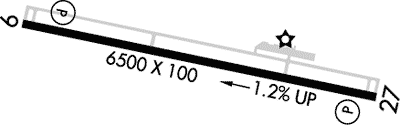
Runway 09/27
Dimensions:
6,500 × 100 ft
(1,981 × 30 m)
(1,981 × 30 m)
Weight Bearing Cap:
Single wheel: 60,000 lbs
Surface:
asphalt, porous friction course, in fair condition
Runway Edge Lights:
Medium
Comments:
Prim Sfc 6-15 Ft Brush 60-250 Ft Fm Cntrln S of Rwy; Brush 75-250 Ft Fm Cntrln N of Cntrln.
FAA
| Designator: | 09 | 27 |
| Elevation: | 3,260.8 ft | 3,181.1 ft |
| Heading: | 090° magnetic 102° true | 270° magnetic 282° true |
| Gradient: | 1.23% down | 1.23% up |
| Traffic Pattern: | Left Pattern | Right Pattern |
| Markings: | non-precision, in Fair condition | non-precision, in Fair condition |
| Approach Lighting: |
|
|
| Displaced Threshold: | n/a | n/a |
| ILS/LOC: | n/a | n/a |
| Obstructions: | n/a | n/a |
| Comments: | 2 Ft Brush 50-200 Ft Fm Thr Acrs Cntrln. FAA | +2-7 Ft Brush 0-200 Ft Fm Thr Acrs Cntrln. FAA |
TFRs
Location: P13
Please verify all content below using the FAA TFR Search Site or with a flight briefer.
TFR count: 0
NOTAMs
Location: P13
Please verify all content below using the FAA NOTAM Search Site or with a flight briefer.
NOTAM count: 5
| Number: | Start Date: (UTC) | End Date: (UTC) | Condition: |
|---|---|---|---|
| 04/180 | 04/18/2025 1220 | RWY 27 RWY END ID LGT U/S | |
| 01/103 | 01/13/2025 2151 | SVC AUTOMATED WX BCST SYSTEM PRESENT WX UNREL | |
| 04/115 | 04/14/2025 1331 | RWY 27 PAPI UNUSABLE | |
| 04/178 | 04/18/2025 1218 | RWY 09 RWY END ID LGT U/S | |
| 04/179 | 04/18/2025 1220 | RWY 09 PAPI U/S | |
Additional Remarks
Lgt Out of service Indef.
Source:
FAA
Federal Aviation Administration
Rwy 27 R Tfc Arms Na.
Source:
FAA
Federal Aviation Administration
Parl Twy Has 2-5 in Cracks.
Source:
FAA
Federal Aviation Administration
Rwy Hold & Twy Exit Signs Out of service Indefly.
Source:
FAA
Federal Aviation Administration
Two Hills S.
Source:
FAA
Federal Aviation Administration
Noise Abatement
Instrument Procedures
Data Cycle:
Operations & More Information
Lat/Long:
- 33.35314, -110.66736
- 33° 21′ 11.3″ N, 110° 40′ 2.5″ W
- 33° 21.188′ N, 110° 40.042′ W
ARTCC:
Albuquerque (ZAB)
App/Depart Control Facility:
Unknown
Chart:
NACO: Phoenix Sectional
FSS:
Prescott (PRC)
1-800-WX-BRIEF
1-800-WX-BRIEF
Wind Indicator:
Lighted
Mag Var:
12E (2000)
NOTAM Facility:
Seg Circle:
Yes
Beacon:
Present
Lighting:
Pilot Activated Lighting:
- low intensity: 3 clicks in 3 secs
- medium intensity: 5 clicks in 5 secs
- high intensity: 7 clicks in 7 secs
AM
Actvt REIL Rwy 09 & 27; PAPI Rwy 09 & 27; MIRL Rwy 09/27 - CTAF.
FAA
Pattern Altitude:
Light Aircraft 4261 MSL
AM
Special Operations:
Communications Card
| Type: | Frequency / Phone: | Sector / Comments: | Call Sign: |
|---|---|---|---|
| AWOS-3 | 120.075T (928) 475-5560 | ||
| CTAF | 122.8 | ||
| UNICOM | 122.8 |
Navaids
Services
Fuel:
100LL Low-Lead, Jet A
AM
Engine Repair:
None
Airframe Repair:
None
Bottled Oxygen:
None
Bulk Oxygen:
None
Customs:
None
Transportation:
None Reported
AM
Activities:
None Reported
Camping On Field:
None Reported
Aircraft & Activity
Webcams
METARs
METARs from this airport:
METARs from nearby reporting stations:
TAFs
TAFs from nearby airports:
Contact Addresses
Airport Manager
Marvin Mull
San Carlos, AZ 85550
(928) 475-3222 (Office)
Owner
San Carlos Apache Tribe
San Carlos, AZ 85550
(928) 475-2361 (Office)
Remarks:
928-475-5563 & 928-812-5790.
FAA
Airport Reviews
Overall:
No ratings | 1 review
Runways and Taxiways:No ratings
Markings and Signage:No ratings
Ground Transportation:No ratings
Sort By:
- 6/10/18Karrol B.They now have self serve fuel (100LL and JetA) at the west ramp. If you park on the west ramp, there is a pedestrian gate so you can walk across the highway to the Apache Gold Casino; their restaurant is a popular breakfast fly-in destination for Ph…
Nearby Events
- airshow
 Description:The North Alabama Airfest is an aviation event held at the Pryor Field Regional Airport (DCU), bringing together aviation enthusiasts, families, and thrill-seekers for a weekend of high-flying fun!
 - social gathering
 Description:Join us for a special opportunity to meet AOPA's new President, Darren Pleasance, as he shares his vision for the future of General Aviation.
 - fly-in
 Description:Join us for the Beechcraft Heritage Museum’s biggest event of the year – Beech Party! A fly-in like no other with amazing educators, pilots, and an array of vintage & modern aircraft.