FAA Information Effective: Jul 10, 2025
All information is provided from the FAA unless otherwise noted.
(PAWI) Wainwright Airport
No ratings | No reviews
Wainwright, AK
(907) 852-0489
Overview
Attendance:
Unattended
Unattended
FAA
Runways:
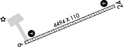
06/24
Runway length: 4,494 ft (1,370 m)
Elevation:
45 ft (Surveyed)
Tower:
No
Airspace:
Unknown
Fees:
None
Timezone:
AKDT (UTC-08:00)
Sunrise-Sunset:
Invalid date - Invalid date
Evening-Morning Civil Twilight:
Invalid date
(Today)
(Today)
-
Invalid date
(Tomorrow)
(Tomorrow)
Runway
Satellite
Sectional
FBOs and Other Businesses
Submit New FBO
AOPA Travel Discounts 
FlightBridge is the ultimate all-in-one travel booking platform built for the general aviation community. AOPA Members receive free access to FlightBridge with AOPA discounted rates automatically applied. Members save an average of 30% on hotel bookings! Learn more about FlightBridge HERE.
Local Food/Lodging/Activities
Local Attractions
Local Activities
Restaurants
Hotels and Lodging
Travel Discounts
Flying Clubs
Submit New Flying Club
Runway 06/24
Dimensions:
4,494 × 110 ft
(1,370 × 34 m)
(1,370 × 34 m)
Weight Bearing Cap:
n/a
Surface:
gravel, no surface treatment, in fair condition
Runway Edge Lights:
Medium
Comments:
40 Ft Twr 500 Ft N of Rwy.
FAA
| Designator: | 06 | 24 |
| Elevation: | 41.5 ft | 39.7 ft |
| Heading: | 055° magnetic 067° true | 235° magnetic 247° true |
| Gradient: | 0.04% down | 0.04% up |
| Traffic Pattern: | Not provided. Assume LEFT traffic pattern | Not provided. Assume LEFT traffic pattern |
| Markings: | n/a | n/a |
| Approach Lighting: |
|
|
| Displaced Threshold: | n/a | n/a |
| ILS/LOC: | n/a | n/a |
| Obstructions: | Antenna, 1,118 ft Left ft of center, 75 ft high, 2,320 ft from end, 30:1 clearance slope | n/a |
| Comments: | n/a | n/a |
TFRs
Location: AWI
Please verify all content below using the FAA TFR Search Site or with a flight briefer.
TFR count: 0
NOTAMs
Location: AWI
Please verify all content below using the FAA NOTAM Search Site or with a flight briefer.
NOTAM count: 4
| Number: | Start Date: (UTC) | End Date: (UTC) | Condition: |
|---|---|---|---|
| 06/013 | 06/12/2025 1915 | RWY 06 PAPI U/S | |
| 06/002 | 06/04/2025 1659 | 09/01/2025 0800 | AD AP BIRD ACT INCREASED |
| 06/012 | 06/12/2025 1912 | RWY 24 PAPI U/S | |
| 07/001 | 07/18/2025 0521 | SVC AUTOMATED WX BCST SYSTEM NOT AVBL | |
Additional Remarks
Barrow FSS - 1-800-779-7709.
Source:
FAA
Federal Aviation Administration
Birds on & In vicinity of Arpt.
Source:
FAA
Federal Aviation Administration
Ramp & Twy Sfc Soft; Ruts & Ponding Psbl.
Source:
FAA
Federal Aviation Administration
Rwy Cond Unmnt; Rcmd Visual Insp Prior to Use.
Source:
FAA
Federal Aviation Administration
Wx Camera Avbl on Internet At Weathercams.FAA.Gov
Source:
FAA
Federal Aviation Administration
Noise Abatement
Instrument Procedures
Data Cycle:
Operations & More Information
Lat/Long:
- 70.63800, -159.99475
- 70° 38′ 16.8″ N, 159° 59′ 41.1″ W
- 70° 38.280′ N, 159° 59.685′ W
ARTCC:
Anchorage (ZAN)
App/Depart Control Facility:
Unknown
Chart:
NACO: Cape Lisburne Sectional
FSS:
Barrow (BRW)
LC852-2511
LC852-2511
Wind Indicator:
Lighted
Mag Var:
12E (2020)
NOTAM Facility:
Seg Circle:
Yes
Beacon:
Present
Lighting:
Actvt REIL Rwy 06 & 24; PAPI Rwy 06 & 24; MIRL Rwy 06/24 - CTAF.
FAA
Pattern Altitude:
No data provided. Assume 1000 AGL.
Special Operations:
Communications Card
| Type: | Frequency / Phone: | Sector / Comments: | Call Sign: |
|---|---|---|---|
| ASOS | 132.25T (907) 763-8881 | ||
| CTAF | 122.8 |
Navaids
Services
Aircraft & Activity
Webcams
METARs
METARs from this airport:
METARs from nearby reporting stations:
TAFs
TAFs from nearby airports:
Contact Addresses
Airport Manager
George Ahmaogak
Barrow, AK 99723
(907) 852-0489 (Office)
Owner
North Slope Borough
Barrow, AK 99723
(907) 852-2611 (Office)
Remarks:
X-342
FAA
Airport Reviews
Nearby Events
- airshow with military demonstration team
 Description:Canadian International Air Show Celebrate North America's longest running air show. The Canadian International Air Show will hold its 76th edition in 2025.
 - airshow with military demonstration team
 Description:The 2025 Wings Over Batavia Air Show will feature modern military aircraft, warbirds and world champion aerobatic performers!

