FAA Information Effective: May 15, 2025
All information is provided from the FAA unless otherwise noted.
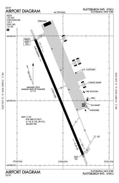
(KPBG) Plattsburgh International Airport
No ratings | No reviews
Overview
Attendance:
Attended
Year-round, 7 Days a Week,0530-2130
FAA
Runways:
17/35
Runway length: 11,759 ft (3,584 m)
Elevation:
234 ft (Surveyed)
Tower:
No
Airspace:
Unknown
Fees:
Timezone:
EDT (UTC-04:00)
Sunrise-Sunset:
5:11 am - 8:36 pm
Evening-Morning Civil Twilight:
9:12 pm
(Today)
(Today)
-
4:34 am
(Tomorrow)
(Tomorrow)
Minimum Fuel Prices:
$6.50
100LL (full)
$6.35
100LL (self)
$6.50
Jet-A (full)
$6.57
Jet-A-Premix/Prist (full)
Runway
Satellite
Sectional
FBOs
Submit New FBO
Avflight Plattsburgh
2 ratings | 2 reviews
Services Offered:
Car Rental
$6.50 | 100LL | full
$6.35 | 100LL | self
$6.50 | Jet-A | full
$6.57 | Jet-A-Premix/Prist | full
Location:
Plattsburgh, NY
Phone:
(518) 324-4300
Freq. Monitored:
UNICOM: 122.7
ASRI: 131.525
ASRI: 131.525
Fees:
Handling, Landing, Other
Flight Training
Submit New Flight School
Other businesses
Submit New Business
AOPA Travel Discounts 
FlightBridge is the ultimate all-in-one travel booking platform built for the general aviation community. AOPA Members receive free access to FlightBridge with AOPA discounted rates automatically applied. Members save an average of 30% on hotel bookings! Learn more about FlightBridge HERE.
Local Food/Lodging/Activities
Local Attractions
Local Activities
Restaurants
Hotels and Lodging
Travel Discounts
Bluff Point Golf Resort
(518) 563-3420
(518) 561-3208
(802) 372-3935
The Barracks Golf Course
(518) 566-7150
(518) 562-8586
(518) 561-3091
(518) 310-1311
(518) 563-6000
(518) 566-6200
Hungry Bear Restaurant
(518) 562-9144
City Taxi
(518) 561-7777
PBG
Bluff Point Golf Resort
Airborne Speedway
Ferry Watch Inn (VT)
Lake Champlain
Transport Museum
The Barracks Golf Course
Bazzano's Pizza
Geoffrey's Pub
Latitude 44 Bistro
Dana's Rusty Anchor
Naked Turtle
Hungry Bear Restaurant
City Taxi
Flying Clubs
Submit New Flying Club
Runway 17/35
Dimensions:
11,759 × 200 ft
(3,584 × 61 m)
(3,584 × 61 m)
Weight Bearing Cap:
Single wheel: 119,000 lbs
Double wheel: 174,000 lbs
Double tandem: 510,000 lbs
Dual double tandem: 780,000 lbs
Double wheel: 174,000 lbs
Double tandem: 510,000 lbs
Dual double tandem: 780,000 lbs
Surface:
asphalt, grooved, in good condition
Runway Edge Lights:
High
Comments:
Pcr Value: 548/F/C/W/T
FAA
| Designator: | 17 | 35 |
| Elevation: | 234.2 ft | 159.8 ft |
| Heading: | 172° magnetic 157° true | 352° magnetic 337° true |
| Gradient: | 0.63% down | 0.63% up |
| Traffic Pattern: | Right Pattern | Left Pattern |
| Markings: | precision, in Good condition | precision, in Good condition |
| Approach Lighting: |
|
|
| Displaced Threshold: | n/a | n/a |
| ILS/LOC: | ILS | ILS/DME |
| Obstructions: | Tree, 630 ft Right ft of center, 68 ft high, 1,600 ft from end, 20:1 clearance slope | Tree, 220 ft Left ft of center, 72 ft high, 1,720 ft from end, 21:1 clearance slope |
| Comments: | n/a | n/a |
TFRs
Location: PBG
Please verify all content below using the FAA TFR Search Site or with a flight briefer.
TFR count: 0
NOTAMs
Location: PBG
Please verify all content below using the FAA NOTAM Search Site or with a flight briefer.
NOTAM count: 7
| Number: | Start Date: (UTC) | End Date: (UTC) | Condition: |
|---|---|---|---|
| 05/035 | 05/29/2025 0414 | 06/12/2025 2359 | OBST TOWER LGT (ASR 1276470) 443757.50N0732946.50W (1.6NM SW PBG) 383.2FT (117.1FT AGL) U/S |
| 05/030 | 05/28/2025 1000 | 06/06/2025 2200 | OBST CRANE (ASN UNKNOWN) 444111N0733107W (2.9NM NW PBG) UNKNOWN (150FT AGL) FLAGGED DLY 1000-2200 |
| 06/001 | 06/04/2025 0503 | 07/19/2025 2359 | OBST WIND TURBINE (ASN 2016-WTE-2383-OE) 445309N0734636W (19.2NM NW PBG) 1250FT (262FT AGL) NOT LGTD |
| 05/033 | 05/28/2025 2043 | 06/28/2025 2300 | OBST TOWER LGT (ASR 1202058) 444149.20N0732656.50W (2.9NM NNE PBG) 318.9FT (199.8FT AGL) U/S |
| 12/271 | 12/26/2024 1345 | APRON MAIN RAMP CLSD EXC TXL | |
| 04/020 | 04/23/2025 1916 | 06/07/2025 0300 | OBST WIND TURBINE LGT (ASN 2016-WTE-1297-OE) 445747N0734639W (22.9NM NW PBG) 1129FT
(262FT AGL) U/S |
| 12/162 | 12/17/2024 1716 | RWY 17 RWY END ID LGT U/S | |
Additional Remarks
Acft Arriving or Departing Pbg Must Announce Intentions on CTAF.
Source:
FAA
Federal Aviation Administration
Acft Depg Rwy 35 Fly Rwy Hdg to Dep End, Otfc Avoid Trml & Trml Apn.
Source:
FAA
Federal Aviation Administration
All Surfaces Work in Progress, Grass Cutting May Thru Nov
Source:
FAA
Federal Aviation Administration
Deer & Birds on & In vicinity of Arpt.
Source:
FAA
Federal Aviation Administration
Durg Pds of Snow Removal Operations Nov 1 - May 1 Acft CTC 122.7 or 518-335-3279 15 Min Prior to Ldg.
Source:
FAA
Federal Aviation Administration
Exp Downdrafts & Turb Durg Pds of Strong Crosswinds.
Source:
FAA
Federal Aviation Administration
For Clearance Delivery Contact Burlington Approach at 802-657-4413, When Approach Clsd CTC Boston ARTCC at 603-879-6859.
Source:
FAA
Federal Aviation Administration
Hel Trng Prohibited W of Rwy 17-35, 1500 Ft Radius.
Source:
FAA
Federal Aviation Administration
Ppr and Arff Index E Call 518-335-3735.
Source:
FAA
Federal Aviation Administration
Skydiving Operations Southeast of Arpt, In vicinity of FBO.
Source:
FAA
Federal Aviation Administration
US Cust Avbl Mon-Fri, 0800-1600 Hours. Prior Permission Required 24 Hours for Aft Hours; CTC Cbp Supvr @ 518-324-5617.
Source:
FAA
Federal Aviation Administration
Ppr 24 Hrs for Unsked Acr Operations with More Than 30 Psgr Seats. Index E Coverage is Avbl Upon Req. 24 Hrs Prior Notice Rqrd. Call Airport Manager At 518-565-4008 or 518-335-3735.
Source:
FAA
Federal Aviation Administration
Security Directive SD-8G
Source:
AM
Airport Manager
Landing fee for aircraft over 12,500 LBS max gross landing weight
Source:
AM
Airport Manager
No landing fee for government aircraft
Source:
AM
Airport Manager
Noise Abatement
Instrument Procedures
Data Cycle:
Operations & More Information
Lat/Long:
- 44.65094, -73.46814
- 44° 39′ 3.4″ N, 73° 28′ 5.3″ W
- 44° 39.057′ N, 73° 28.088′ W
ARTCC:
Boston (ZBW)
App/Depart Control Facility:
BTV
Chart:
NACO: Montreal Sectional
FSS:
Burlington (BTV)
1-800-WX-BRIEF
1-800-WX-BRIEF
Wind Indicator:
Lighted
Mag Var:
15W (1985)
NOTAM Facility:
Seg Circle:
Yes
Beacon:
Present
Lighting:
Pilot Activated Lighting:
- low intensity: 3 clicks in 5 secs
- medium intensity: 5 clicks in 5 secs
- high intensity: 7 clicks in 5 secs
AM
Actvt MALSR Rwy 35; REIL Rwy 17; HIRL Rwy 17/35; Twy Lgts - CTAF.
FAA
Pattern Altitude:
No data provided. Assume 1000 AGL.
Special Operations:
Communications Card
| Type: | Frequency / Phone: | Sector / Comments: | Call Sign: |
|---|---|---|---|
| Approach/Departure | 121.1 | Burlington | |
| ASOS | 132.225T (518) 324-5539 | ||
| Clearance Delivery | 121.85 | CTC APCH CTL | Burlington |
| Clearance Delivery Phone | (802) 657-4413 | Burlington Approach | |
| Clearance Delivery Phone | (603) 879-6859 | When Approach Closed | Boston ARTCC |
| CTAF | 122.7 | ||
| UNICOM | 122.7 |
Navaids
Services
Fuel:
100LL Low-Lead, Jet A
AM
Engine Repair:
None
Airframe Repair:
Minor
AM
Bottled Oxygen:
High
AM
Bulk Oxygen:
None
Customs:
None
Transportation:
None Reported
AM
Activities:
Airline Services
AM
Camping On Field:
None Reported
Aircraft & Activity
Webcams
METARs
TAFs
Contact Addresses
Airport Manager
Christopher D. Kreig
Plattsburgh, NY 12903
(518) 565-4794 (Office)
Owner
Clinton County
Plattsburgh, NY 12901
(518) 565-4600 (Office)