FAA Information Effective: Jul 10, 2025
All information is provided from the FAA unless otherwise noted.
(S33) Madras Municipal Airport
No ratings | 2 reviews
Madras, OR
(541) 777-4935
Overview
Attendance:
Attended
Year-round,Mon-Fri/0800-1700
FAA
Year-round,Sat-Sun/0900-1400
FAA
Elevation:
2,438 ft (Surveyed)
Tower:
No
Airspace:
Unknown
Fees:
None
Timezone:
PDT (UTC-07:00)
Sunrise-Sunset:
5:43 am - 8:40 pm
Evening-Morning Civil Twilight:
9:15 pm
(Today)
(Today)
-
5:10 am
(Tomorrow)
(Tomorrow)
Runway
Satellite
Sectional
FBOs and Other Businesses
Submit New FBO
AOPA Travel Discounts 
FlightBridge is the ultimate all-in-one travel booking platform built for the general aviation community. AOPA Members receive free access to FlightBridge with AOPA discounted rates automatically applied. Members save an average of 30% on hotel bookings! Learn more about FlightBridge HERE.
Local Food/Lodging/Activities
Local Attractions
Local Activities
Restaurants
Hotels and Lodging
Travel Discounts
Deschutes River
Kah-Nee-Ta Resort
Lake Billy Chinook
Indian Head Csino-Kah-Nee-Ta
Ahern's Deli
(541) 475-3106
Subway
(541) 475-7560
McDonald's
(541) 475-3580
Dairy Queen
(541) 475-2337
Ding Ho
(541) 475-4610
High Desert
(541) 475-5892
Fish's Shuttle Service
(541) 475-3129
2408 NW Berg Drive, Madras, OR 97741
(541) 460-5065
S33
Deschutes River
Kah-Nee-Ta Resort
Lake Billy Chinook
Indian Head Csino-Kah-Nee-Ta
Ahern's Deli
Subway
McDonald's
Dairy Queen
Ding Ho
High Desert
Fish's Shuttle Service
Erickson Aircraft Collection
Flying Clubs
Submit New Flying Club
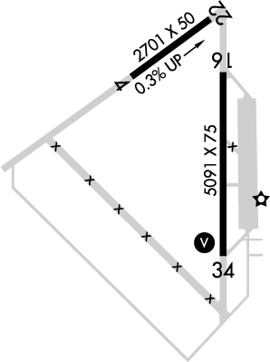
Runway 16/34
Dimensions:
5,091 × 75 ft
(1,552 × 23 m)
(1,552 × 23 m)
Weight Bearing Cap:
Single wheel: 75,000 lbs
Double wheel: 120,000 lbs
Double tandem: 180,000 lbs
Double wheel: 120,000 lbs
Double tandem: 180,000 lbs
Surface:
asphalt, no surface treatment, in good condition
Runway Edge Lights:
Medium
Comments:
n/a
| Designator: | 16 | 34 |
| Elevation: | 2,430.3 ft | 2,437.4 ft |
| Heading: | 164° magnetic 180° true | -16° magnetic 000° true |
| Gradient: | 0.14% up | 0.14% down |
| Traffic Pattern: | Left Pattern | Left Pattern |
| Markings: | non-precision, in Good condition | non-precision, in Good condition |
| Approach Lighting: | n/a |
|
| Displaced Threshold: | n/a | n/a |
| ILS/LOC: | n/a | n/a |
| Obstructions: | n/a | n/a |
| Comments: | n/a | n/a |
Runway 04/22
Dimensions:
2,701 × 50 ft
(823 × 15 m)
(823 × 15 m)
Weight Bearing Cap:
Single wheel: 16,000 lbs
Surface:
asphalt, no surface treatment, in fair condition
Runway Edge Lights:
n/a
Comments:
n/a
| Designator: | 04 | 22 |
| Elevation: | 2,417 ft | 2,424.7 ft |
| Heading: | 039° magnetic 055° true | 219° magnetic 235° true |
| Gradient: | 0.29% up | 0.29% down |
| Traffic Pattern: | Left Pattern | Left Pattern |
| Markings: | basic, in Fair condition | basic, in Fair condition |
| Approach Lighting: | n/a | n/a |
| Displaced Threshold: | n/a | n/a |
| ILS/LOC: | n/a | n/a |
| Obstructions: | n/a | Road, 240 ft Right ft of center, 15 ft high, 200 ft from end |
| Comments: | Ry 04/22 Mkd with White Reflectors. FAA | +5 Ft Fence 190 Ft Fm Ry End 228 Ft R. FAA |
TFRs
Location: S33
Please verify all content below using the FAA TFR Search Site or with a flight briefer.
TFR count: 0
NOTAMs
Location: S33
Please verify all content below using the FAA NOTAM Search Site or with a flight briefer.
NOTAM count: 8
| Number: | Start Date: (UTC) | End Date: (UTC) | Condition: |
|---|---|---|---|
| 07/247 | 07/24/2025 1500 | 07/24/2025 2200 | AIRSPACE SEE DSD 07/35 PJE |
| 07/249 | 07/24/2025 1500 | 07/24/2025 2200 | AIRSPACE SEE DSD 07/035 PJE |
| 4/7708 | 05/02/2024 1535 | IAP MADRAS MUNI, MADRAS, OR.
RNAV (GPS) RWY 16, AMDT 1C...
AIRPORT ELEVATION 2438.
TDZE 2434.
LPV DA 2784 AL… | |
| 07/195 | 07/20/2025 0523 | 08/03/2025 0500 | AIRSPACE SEE FDC 5/1073 ZSE 91.137 HAZARD |
| 07/241 | 07/24/2025 1400 | 07/24/2025 2000 | AIRSPACE SEE ZSE 07/369 UAS |
| 06/257 | 06/27/2025 0456 | 09/27/2025 2359 | OBST TOWER LGT (ASR 1203068) 450132.10N1205019.70W (25.28NM NNE S33) 4025FT (379FT AGL) U/S |
| 04/021 | 04/05/2025 1338 | 12/31/2025 0034 | AIRSPACE PJE WI AN AREA DEFINED AS 3NM RADIUS OF S33 SFC-12000FT AGL DLY SR-SS |
| 07/243 | 07/25/2025 0500 | 07/25/2025 1130 | AIRSPACE UAS WI AN AREA DEFINED AS 0.5NM RADIUS OF
444132N1211043W (1.7NM NW S33) SFC-50FT AGL |
Additional Remarks
Cold Temperature Airport. Altitude Correction Required At or Below -20C.
Source:
FAA
Federal Aviation Administration
Deer, Coyote and Cougar on & In vicinity of Arpt.
Source:
FAA
Federal Aviation Administration
For Clearance Delivery Contact Seattle ARTCC at 253-351-3694.
Source:
FAA
Federal Aviation Administration
Noise Abatement
| Runway: | Applies to: | Approach/Departure: | Text: |
|---|---|---|---|
| All | All Aircraft | Both | Avoid houses 3/4 mi S of departure end of ry 16 |
Instrument Procedures
Data Cycle:
Operations & More Information
Lat/Long:
- 44.67016, -121.15515
- 44° 40′ 12.6″ N, 121° 9′ 18.5″ W
- 44° 40.210′ N, 121° 9.309′ W
ARTCC:
Seattle (ZSE)
App/Depart Control Facility:
Unknown
Chart:
NACO: Seattle Sectional
FSS:
Mc Minnville (MMV)
1-800-WX-BRIEF
1-800-WX-BRIEF
Wind Indicator:
Lighted
Mag Var:
16E (2010)
NOTAM Facility:
Seg Circle:
No
Beacon:
Present
Lighting:
Pilot Activated Lighting:
- low intensity: 3 clicks in 5 secs
- medium intensity: 5 clicks in 10 secs
- high intensity: 7 clicks in 10 secs
AM
Actvt REIL Rwy 34; VASI Rwy 34; Mril Rwy 16/34 - CTAF
FAA
Pattern Altitude:
Light Aircraft 3200 MSL
Heavy Aircraft 3400 MSL
AM
Special Operations:
Communications Card
| Type: | Frequency / Phone: | Sector / Comments: | Call Sign: |
|---|---|---|---|
| AWOS-3PT | 132.425T (541) 475-0494 | ||
| Clearance Delivery Phone | (253) 351-3694 | Seattle ARTCC | |
| CTAF | 122.8 | ||
| UNICOM | 122.8 |
Navaids
Services
Fuel:
100LL Low-Lead, Jet A
AM
Engine Repair:
Major
AM
Airframe Repair:
Major
AM
Bottled Oxygen:
High/Low
AM
Bulk Oxygen:
None
Customs:
None
Transportation:
Courtesy Transportation
AM
Activities:
None Reported
Camping On Field:
None Reported
Aircraft & Activity
Webcams
METARs
TAFs
Contact Addresses
Airport Manager
Lorraine Martinelli
Madras, OR 97741
(541) 777-4935 (Office)
Owner
City
Madras, OR 97741
(541) 475-2344 (Office)
Airport Reviews
Overall:
No ratings | 2 reviews
Runways and Taxiways:No ratings
Markings and Signage:No ratings
Ground Transportation:No ratings
Sort By:
- 6/17/17STEPHEN G.Exceptional service, without compare. One could not have asked for a friendlier, quicker reception, even though it was late in the evening, or more personal attention. Far above and beyond what one should expect, and most welcome at the end of a long…
- 1/23/15RICHARD M.The Erickson Aircraft Collection is located on the field and proudly displays a vintage aircraft collection started by Jack Erickson in 1983. The collection features over twenty rare aircraft, most of which are still in flying condition. The Collecti…