Mentor Matters: Cold weather and misleading altimeters
You’re not always where you think you are
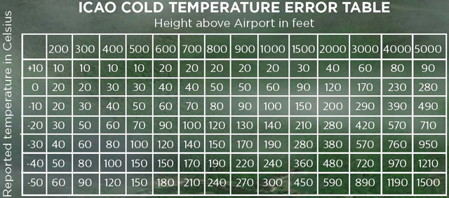
Most of the time the difference between indicated and true altitude is negligible. Flying the ILS 33 into KBTV on a very cold day, however, the difference between where a pilot thinks he or she is and the actual altitude can be greater than the separation afforded by the published approach (see ILS approach plate). To use the ICAO Cold Temperature Error Table (on page 7-2-5 of the Aeronautical Information Manual) find the temperature on the left side of the chart, then locate the altitude above the airport on the top row. Where the two values intersect, that’s how much lower than indicated you will be.
On one of my first flights into Burlington International Airport, Vermont (BTV) as a new regional airline turboprop pilot I experienced a glaring flaw inherent in all barometric altimeters. Cleared for the ILS 33 approach and descending in VMC over the Green Mountains, I found myself gaping at the abnormal proximity of the granite peaks just as the aircraft’s ground proximity warning system (GPWS) commanded we immediately pull up. Per company procedures we were able to legally continue the approach by maintaining visual separation from the terrain, but had we been in IMC we would have been compelled to execute a missed approach—while still more than a dozen miles from the airport.
I was unsettled enough by the experience to spend some time looking into how we could have been so close to terrain while flying at the proper approach altitude, and discovered that Transport Canada required corrections be applied to approach altitudes when the temperature was significantly below normal—as it was on this trip. At the time, the FAA didn’t even provide advisory information in the Aeronautical Information Manual on the subject. Coincidentally, not long after my event, the ICAO altimeter correction table was added to the AIM, with the advice that pilots could, if they wished, apply the corrections to approach segments.
A decade and a half later, the FAA recently converted an optional procedure into a mandatory one with the inclusion of the Cold Temperature Restricted Airports section in the December 11, 2014, publication of Notices to Airmen. This section for the first time requires that “Pilots must make an altitude correction to the published…altitudes on designated segment(s)…on all published procedures” at specified airports when the reported surface temperature is at or below a specified limit. The list is attached to the notam.
On government approach plates for applicable airports, the temperature threshold at which a correction is required will be indicated beside a snowflake symbol. For many airports, there are two temperature thresholds that trigger altitude adjustments along different segments. For example, at Rutland, Vermont (RUT), if the temperature is at or below minus 5 degrees C—but above minus 18 degrees C—corrections must be applied to the final segment only. If the temperature is at or below minus 18 degrees C, however, both the intermediate and final segments must be corrected. In this case the warmer threshold of minus 5 degrees C will be displayed on Rutland terminal procedures diagrams.
Why do these this corrections need to be applied at all? Altimeters—whether stand-alone round dials or those found on the newest glass panels—do not measure altitude at all, but rather pressure. Given a standard atmosphere, it is simple for the instrument to convert a pressure reading into a mean sea level (MSL) altitude display. Of course, the atmosphere is almost never standard, so pilots are taught to apply nonstandard pressure corrections to the altimeter by entering adjusted sea-level pressure into the Kollsman window.
Pressure is only one of the two major variables that can deviate from the international standard atmosphere (ISA). The other—temperature—is more difficult to adjust for, as the magnitude of the error between indicated and actual altitude varies not just with the temperature deviation from ISA, but also with the height of the aircraft above the pressure reporting location—typically the landing airport. This error is approximately four feet per degree Celsius of temperature deviation, per 1,000 feet above reporting altitude. If the temperature is minus 10 degrees C (25 degrees C colder than standard) at the landing airport, at 1,000 feet above the airport the aircraft will actually be 100 feet lower than the altimeter reports; at 4,000 feet above the airport the error will be roughly 400 feet.
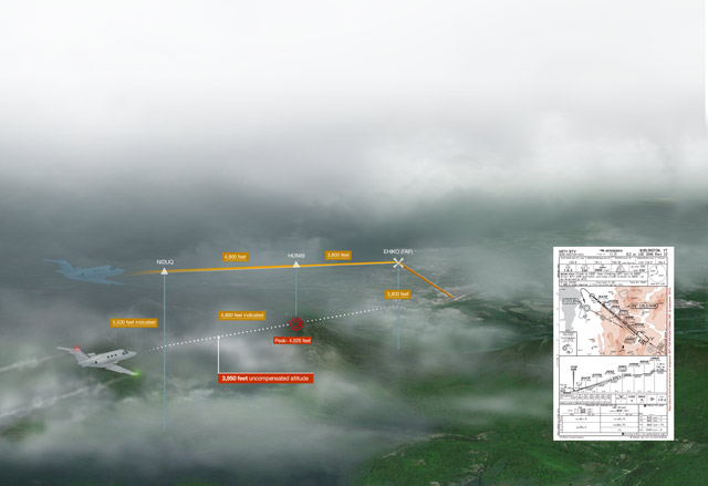
Applying this table to the ILS 33 into Burlington, it becomes apparent how significant—and dangerous—cold-weather altimeter error can be. Between NIDUQ and HONIB, aircraft are allowed to fly at 4,026 feet msl. Doing so, they will pass very near a mountain peak reaching to 4,088 feet msl (see illustration). The 774-foot theoretical clearance exceeds the 500 feet required on intermediate legs of procedures, so in an ISA world, all is well.
In the depths of winter, however, the temperature at Burlington can fall to decidedly non-ISA lows—minus 30 degrees C is not uncommon in January. On an evening when the temperature at the airport is minus 30 degrees C, an aircraft flying at 4,800 feet indicated is about 4,500 feet above the Burlington airport. This will yield an altimeter error of roughly 850 feet; thus an aircraft flying at 4,800 feet indicated altitude is actually just under 4,000 feet msl—almost 100 feet below the highest terrain on the approach. That’s why a GPWS, which takes its cues from radar and/or GPS altitude—neither affected by the cold—can be unhappy with the approach leg that straddles the mountain ridge.
Most modern flight decks can automate the necessary temperature corrections, freeing the pilot from workload-intensive and error-prone manual calculations. Both Garmin- and Rockwell Collins-based flight decks operating with the latest software take care of the calculations with a simple menu selection. The pilot tells the system that he wishes to apply temperature compensation, and then inputs the temperature at the landing airport.
If the pilot has already loaded an approach, the system will correct each flight plan altitude associated with approach legs, themselves automatically loaded with the approach. The pilot can then either fly the aircraft along step-downs using the corrected altitudes that are displayed in the flight plan—or, better yet, via vertical navigation (VNAV), which will use the corrected altitudes for each leg. In the Garmin system, if the pilot has entered approach minimums, those also can be automatically adjusted for temperature, and the pilot will hear the aural “minimums” alert at the proper, corrected altitude.
Neil Singer is a Master CFI with more than 8,500 hours in 15 years of flying.
Related Articles


