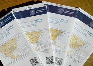
FAA announces plan to replace WACs
New Alaska, Caribbean charts will fill gaps
 Following extensive discussions with AOPA, the FAA has announced a new plan to ensure that pilots have all the information they need as the agency phases out world aeronautical charts (WACs).
In an Oct. 29 announcement, the FAA said it will produce an Alaska VFR Wall Planning Chart to help pilots as they plan long-distance flights. The wall chart will show all of Alaska as well as the Canadian territory between Washington State and Alaska. The FAA also will produce two new Caribbean VFR Aeronautical Charts that will provide more coverage than is available with the three WACs they will replace. The scale for the Caribbean charts will be 1 to 1 million.
The new charts should be available in early January 2017, when the existing WACs for those areas expire. See a list of sectional charts that will provide coverage for WAC charts that are discontinued.
“These new charts should address the key concerns raised by AOPA members, but we will stay in touch with members and continue to work together with the FAA to make sure pilots have the information they need to safely plan their flights,” said Rune Duke, AOPA director of airspace and air traffic. “We appreciate the FAA’s responsiveness and willingness to work with us to fill the gap left by the decision to stop producing WACs.”
In June, the FAA announced that it would no longer produce WACs beginning in September. But following a meeting with AOPA in July, the agency agreed to work with stakeholders regarding the future of WACs. The FAA also agreed to publish all regularly scheduled updates to WAC charts expiring before January 2016.
As part of its discussions with the FAA, AOPA conducted a survey of more than 740 members, asking how they use WACs and what supplemental information they might need if WACs were discontinued. Members reported that eliminating WACs would leave them with insufficient information for planning flights to the Caribbean and Alaska. The newly announced wall planning and VFR charts are designed to fill those information gaps and provide more detail than was previously available.
"The FAA's Office of Aeronautical Information Services looks forward to introducing the Alaska VFR Wall Planning Chart and the Caribbean VFR Aeronautical Charts to the public when they become available," said Eric Freed, manager of the FAA's enroute and visual charting group.
Pilots flying VFR will be able to continue to use sectional charts, which provide coverage of all U.S. territory at a higher resolution than WACs. The FAA also will be improving the chart indexing graphic to better describe the areas depicted, and the agency will revise the U.S. VFR Wall Planning Chart.
Budget pressures and rapidly declining use of WACs led to the FAA decision to stop production of the 21 charts, which require six full-time workers to maintain and update. Many other countries, including Canada, also have stopped producing WACs. Pilots who fly internationally, including in Mexico and Canada, are urged to use those countries’ government-sponsored charts for their flights as the FAA cannot always keep international information up to date. As part of the transition, references to WACs in the Aeronautical Information Manual and other pilot literature will begin to be removed later this year.


