FAA Information Effective: Jul 10, 2025
All information is provided from the FAA unless otherwise noted.
(1O4) Thomas Municipal Airport
No ratings | No reviews
Thomas, OK
(580) 603-2636
Overview
Attendance:
Attended
Year-round,Mon-Fri/0800-1700
FAA
Runways:
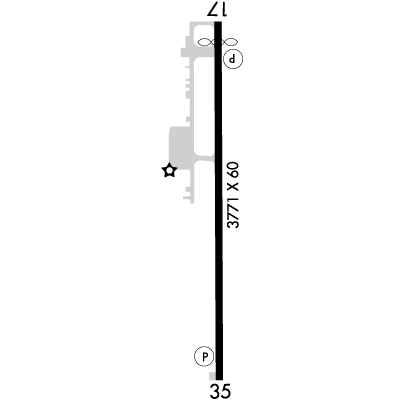
17/35
Runway length: 3,771 ft (1,149 m)
Elevation:
1,733 ft (Surveyed)
Tower:
No
Airspace:
Unknown
Fees:
None
Timezone:
CDT (UTC-05:00)
Sunrise-Sunset:
6:39 am - 8:45 pm
Evening-Morning Civil Twilight:
9:14 pm
(Today)
(Today)
-
6:11 am
(Tomorrow)
(Tomorrow)
Runway
Satellite
Sectional
FBOs and Other Businesses
Submit New FBO
AOPA Travel Discounts 
FlightBridge is the ultimate all-in-one travel booking platform built for the general aviation community. AOPA Members receive free access to FlightBridge with AOPA discounted rates automatically applied. Members save an average of 30% on hotel bookings! Learn more about FlightBridge HERE.
Local Food/Lodging/Activities
Local Attractions
Local Activities
Restaurants
Hotels and Lodging
Travel Discounts
Flying Clubs
Submit New Flying Club
Runway 17/35
Dimensions:
3,771 × 60 ft
(1,149 × 18 m)
(1,149 × 18 m)
Weight Bearing Cap:
Single wheel: 4,000 lbs
Surface:
asphalt, no surface treatment, in good condition
Runway Edge Lights:
Medium
Comments:
n/a
| Designator: | 17 | 35 |
| Elevation: | 1,731.8 ft | 1,732.4 ft |
| Heading: | 175° magnetic 180° true | 355° magnetic 360° true |
| Gradient: | 0.02% up | 0.02% down |
| Traffic Pattern: | Left Pattern | Right Pattern |
| Markings: | non-precision, in Fair condition | non-precision, in Fair condition |
| Approach Lighting: |
|
|
| Displaced Threshold: | 212 ft | n/a |
| ILS/LOC: | n/a | n/a |
| Obstructions: | Road, Both-Sides, 18 ft high, 339 ft from end, 7:1 clearance slope | n/a |
| Comments: | Papi Unusable Byd 8 Degs Right of Cntrln. FAA | n/a |
TFRs
Location: 1O4
Please verify all content below using the FAA TFR Search Site or with a flight briefer.
TFR count: 0
NOTAMs
Location: 1O4
Please verify all content below using the FAA NOTAM Search Site or with a flight briefer.
NOTAM count: 3
| Number: | Start Date: (UTC) | End Date: (UTC) | Condition: |
|---|---|---|---|
| 06/329 | 06/15/2025 1945 | 09/13/2025 0400 | OBST TOWER LGT (ASR 1010977) 355208.00N0985902.90W (14.8NM WNW 1O4) 2477.0FT (495.1FT AGL) U/S |
| 07/294 | 07/26/2025 0232 | 08/10/2025 0132 | OBST TOWER LGT (ASR 1269939) 355538.20N0984246.10W (11.6NM NE 1O4) 2236.2FT (349.1FT AGL) U/S |
| 5/3364 | 06/12/2025 1446 | IAP THOMAS MUNI, THOMAS, OK.
RNAV (GPS) RWY 35, ORIG...
LNAV/VNAV CATS A/B DA 2332/HAT 599. VIS CATS A/B 1 3… | |
Additional Remarks
For Clearance Delivery Contact Fort Worth ARTCC at 817-858-7584.
Source:
FAA
Federal Aviation Administration
Noise Abatement
Instrument Procedures
Data Cycle:
Operations & More Information
Lat/Long:
- 35.73367, -98.73053
- 35° 44′ 1.2″ N, 98° 43′ 49.9″ W
- 35° 44.020′ N, 98° 43.832′ W
ARTCC:
Fort Worth (ZFW)
App/Depart Control Facility:
Unknown
Chart:
NACO: Dallas-Ft Worth Sectional
FSS:
Mc Alester (MLC)
1-800-WX-BRIEF
1-800-WX-BRIEF
Wind Indicator:
Lighted
Mag Var:
05E (2015)
NOTAM Facility:
Seg Circle:
No
Beacon:
Present
Lighting:
Dusk-Dawn. MIRL Ry 17/35 Preset on Low Intst; to Incr Intst Actvt - CTAF.
FAA
Pattern Altitude:
No data provided. Assume 1000 AGL.
Special Operations:
Communications Card
| Type: | Frequency / Phone: | Sector / Comments: | Call Sign: |
|---|---|---|---|
| Clearance Delivery Phone | (817) 858-7584 | Fort Worth ARTCC | |
| CTAF | 122.9 |
Navaids
Services
Fuel:
100LL Low-Lead
AM
Engine Repair:
None
Airframe Repair:
None
Bottled Oxygen:
None
Bulk Oxygen:
None
Customs:
None
Transportation:
None Reported
AM
Activities:
None Reported
Camping On Field:
None Reported
Aircraft & Activity
Webcams
METARs
TAFs
Contact Addresses
Airport Manager
Rodney Wilson
Thomas, OK 73669
(580) 603-2636 (Office)
Owner
City of Thomas
Thomas, OK 73669
(580) 603-2636 (Office)