FAA Information Effective: Jun 12, 2025
All information is provided from the FAA unless otherwise noted.
(KJAS) Jasper County/Bell Field
No ratings | 1 review
Jasper, TX
(409) 384-5343
Overview
Attendance:
Attended
Year-round, 7 Days a Week,0800-1700
FAA
Runways:
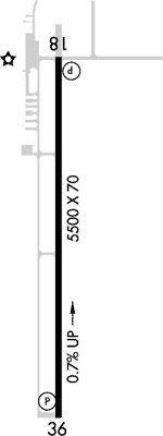
18/36
Runway length: 5,500 ft (1,676 m)
Elevation:
213 ft (Surveyed)
Tower:
No
Airspace:
Unknown
Fees:
None
Timezone:
CDT (UTC-05:00)
Sunrise-Sunset:
6:13 am - 8:22 pm
Evening-Morning Civil Twilight:
8:49 pm
(Today)
(Today)
-
5:46 am
(Tomorrow)
(Tomorrow)
Runway
Satellite
Sectional
FBOs and Other Businesses
Submit New FBO
AOPA Travel Discounts 
FlightBridge is the ultimate all-in-one travel booking platform built for the general aviation community. AOPA Members receive free access to FlightBridge with AOPA discounted rates automatically applied. Members save an average of 30% on hotel bookings! Learn more about FlightBridge HERE.
Local Food/Lodging/Activities
Local Attractions
Local Activities
Restaurants
Hotels and Lodging
Travel Discounts
Flying Clubs
Submit New Flying Club
Runway 18/36
Dimensions:
5,500 × 70 ft
(1,676 × 21 m)
(1,676 × 21 m)
Weight Bearing Cap:
Single wheel: 21,000 lbs
Surface:
asphalt, no surface treatment, in good condition
Runway Edge Lights:
Medium
Comments:
n/a
| Designator: | 18 | 36 |
| Elevation: | 212.5 ft | 177.6 ft |
| Heading: | 177° magnetic 181° true | 0-3° magnetic 001° true |
| Gradient: | 0.63% down | 0.63% up |
| Traffic Pattern: | Left Pattern | Left Pattern |
| Markings: | non-precision, in Good condition | non-precision, in Good condition |
| Approach Lighting: |
|
|
| Displaced Threshold: | n/a | n/a |
| ILS/LOC: | n/a | n/a |
| Obstructions: | Trees, Both-Sides, 89 ft high, 2,515 ft from end, 26:1 clearance slope | Trees, Both-Sides, 79 ft high, 1,890 ft from end, 21:1 clearance slope |
| Comments: | n/a | n/a |
TFRs
Location: JAS
Please verify all content below using the FAA TFR Search Site or with a flight briefer.
TFR count: 0
NOTAMs
Location: JAS
Please verify all content below using the FAA NOTAM Search Site or with a flight briefer.
NOTAM count: 5
| Number: | Start Date: (UTC) | End Date: (UTC) | Condition: |
|---|---|---|---|
| 06/005 | 06/09/2025 0128 | 06/24/2025 0128 | OBST TOWER LGT (ASR 1053390) 305832.00N0935925.00W (5.9NM NNE JAS) 919.9FT (499.0FT AGL) U/S |
| 05/021 | 05/29/2025 0414 | 07/13/2025 0414 | OBST TOWER LGT (ASN 2017-ASW-6148-OE) 310030N0941222W (11.4NM NW JAS) 379FT (213FT AGL) U/S |
| 04/005 | 04/13/2025 1133 | 08/11/2025 1133 | OBST TOWER LGT (ASR 1047162) 305840.30N0935930.00W (6.0NM NNE JAS) 895.0FT (494.1FT AGL) U/S |
| 06/008 | 06/12/2025 1231 | 10/10/2025 1231 | OBST TOWER LGT (ASR 1048990) 310450.20N0941641.10W (17.1NM NW JAS) 636.2FT (266.1FT AGL) U/S |
| 06/009 | 06/13/2025 1730 | 07/28/2025 1730 | OBST TOWER LGT (ASN 2018-ASW-3196-OE) 305618N0940715W (5.4NM NW JAS) 394FT (210FT AGL) U/S |
Additional Remarks
For Cd If Una to CTC on FSS Freq, CTC Houston ARTCC at 281-230-5622.
Source:
FAA
Federal Aviation Administration
Noise Abatement
Instrument Procedures
Data Cycle:
Operations & More Information
Lat/Long:
- 30.88569, -94.03494
- 30° 53′ 8.5″ N, 94° 2′ 5.8″ W
- 30° 53.142′ N, 94° 2.097′ W
ARTCC:
Houston (ZHU)
App/Depart Control Facility:
Unknown
Chart:
NACO: Houston Sectional
FSS:
Montgomery County (CXO)
1-800-WX-BRIEF
1-800-WX-BRIEF
Wind Indicator:
Lighted
Mag Var:
04E (1995)
NOTAM Facility:
Seg Circle:
Yes
Beacon:
Present
Lighting:
Mirl Rwy 18/36 Preset Low Intst; to Incr Intst Actvt - CTAF. PAPI Rwy 18 & 36 Oprs Consly.
FAA
Pattern Altitude:
No data provided. Assume 1000 AGL.
Special Operations:
Communications Card
| Type: | Frequency / Phone: | Sector / Comments: | Call Sign: |
|---|---|---|---|
| AWOS-3 | 118.375T (409) 489-1603 | ||
| CTAF | 122.8 | ||
| UNICOM | 122.8 |
Navaids
Services
Fuel:
100LL Low-Lead, Jet A
AM
Engine Repair:
Major
AM
Airframe Repair:
Major
AM
Bottled Oxygen:
None
Bulk Oxygen:
None
Customs:
None
Transportation:
Courtesy Transportation
AM
Activities:
None Reported
Camping On Field:
None Reported
Aircraft & Activity
Webcams
METARs
TAFs
Contact Addresses
Airport Manager
Chris Ruiz
Jasper, TX 75951
(409) 384-5343 (Office)
Owner
Jasper County
Jasper, TX 75951
(409) 384-5343 (Office)
Remarks:
Emer Aft Hrs 409-382-2835
FAA
Kevin Holloway, County Commissioner
FAA
Airport Reviews
Overall:
No ratings | 1 review
Runways and Taxiways:No ratings
Markings and Signage:No ratings
Ground Transportation:No ratings
Sort By:
- 9/14/16DOUGLAS H.Pilots beware ramp Fee at Jasper airport now in SE Texas , also called Bell Field ! Flying from my home airport 30 min. Southwest of KJAS we decided to stop in Jasper and eat lunch and rent a car and drive up to Pineland. Lunch was good and quick tri…
