FAA Information Effective: Jul 10, 2025
All information is provided from the FAA unless otherwise noted.
(KAIV) George Downer Airport
No ratings | No reviews
Overview
Attendance:
Unattended
Unattended
FAA
Runways:
06/24
Runway length: 5,001 ft (1,524 m)
Elevation:
150 ft (Surveyed)
Tower:
No
Airspace:
Unknown
Fees:
None
Timezone:
CDT (UTC-05:00)
Sunrise-Sunset:
6:01 am - 7:59 pm
Evening-Morning Civil Twilight:
8:27 pm
(Today)
(Today)
-
5:34 am
(Tomorrow)
(Tomorrow)
Runway
Satellite
Sectional
FBOs and Other Businesses
Submit New FBO
AOPA Travel Discounts 
FlightBridge is the ultimate all-in-one travel booking platform built for the general aviation community. AOPA Members receive free access to FlightBridge with AOPA discounted rates automatically applied. Members save an average of 30% on hotel bookings! Learn more about FlightBridge HERE.
Local Food/Lodging/Activities
Local Attractions
Local Activities
Restaurants
Hotels and Lodging
Travel Discounts
AIV
Aliceville Museum
Plantation House & Gardens
Jack's
Flying Clubs
Submit New Flying Club
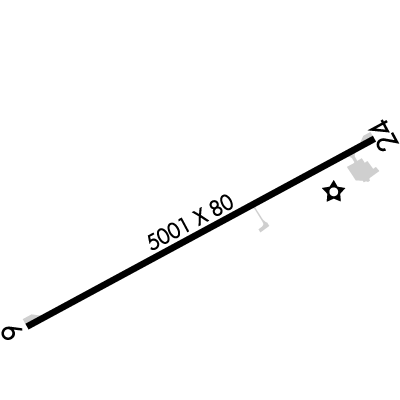
Runway 06/24
Dimensions:
5,001 × 80 ft
(1,524 × 24 m)
(1,524 × 24 m)
Weight Bearing Cap:
n/a
Surface:
asphalt, no surface treatment, in good condition
Runway Edge Lights:
Medium
Comments:
n/a
| Designator: | 06 | 24 |
| Elevation: | 142.8 ft | 149.8 ft |
| Heading: | 064° magnetic 062° true | 244° magnetic 242° true |
| Gradient: | 0.14% up | 0.14% down |
| Traffic Pattern: | Left Pattern | Left Pattern |
| Markings: | non-precision, in Poor condition | non-precision, in Poor condition |
| Approach Lighting: |
|
|
| Displaced Threshold: | n/a | n/a |
| ILS/LOC: | n/a | n/a |
| Obstructions: | Tree, 104 ft Right ft of center, 30 ft high, 733 ft from end, 17:1 clearance slope | Tree, 73 ft Right ft of center, 81 ft high, 1,983 ft from end, 22:1 clearance slope |
| Comments: | Markings Faded. FAA | Markings Faded. FAA |
TFRs
Location: AIV
Please verify all content below using the FAA TFR Search Site or with a flight briefer.
TFR count: 0
NOTAMs
Location: AIV
Please verify all content below using the FAA NOTAM Search Site or with a flight briefer.
NOTAM count: 6
| Number: | Start Date: (UTC) | End Date: (UTC) | Condition: |
|---|---|---|---|
| 5/2029 | 07/02/2025 1430 | IAP GEORGE DOWNER, ALICEVILLE, AL.
RNAV (GPS) RWY 24, ORIG-A...
LNAV MDA 820/HAT 670 ALL CATS. VISIBILITY CA… | |
| 07/202 | 07/09/2025 0247 | 08/23/2025 0247 | OBST TOWER LGT (ASN 2018-ASO-25807-OE) 325707N0881353W (9.5NM S AIV) 458FT (315FT AGL) U/S |
| 05/434 | 05/13/2025 1213 | RWY 06 RWY END ID LGT U/S | |
| 06/911 | 06/20/2025 2046 | 09/18/2025 0400 | OBST TOWER LGT (ASR 1039257) 331234.90N0880801.60W (7.0NM NNE AIV) 792.0FT (477.0FT AGL) U/S |
| 07/562 | 07/20/2025 1845 | 11/17/2025 1845 | OBST TOWER LGT (ASR 1255152) 325853.00N0880159.50W (11.1NM SE AIV) 492.8FT (257.9FT AGL) U/S |
| 5/6868 | 03/24/2025 1538 | IAP GEORGE DOWNER, ALICEVILLE, AL.
RNAV (GPS) RWY 24, ORIG-A...
RNAV (GPS) RWY 6, ORIG-C...
CIRCLING CAT D M… | |
Additional Remarks
For Clearance Delivery Contact Columbus Approach at 662-434-3044.
Source:
FAA
Federal Aviation Administration
Twy Lgts for Twy Turnoff Only.
Source:
FAA
Federal Aviation Administration
Noise Abatement
Instrument Procedures
Data Cycle:
Operations & More Information
Lat/Long:
- 33.10674, -88.19718
- 33° 6′ 24.3″ N, 88° 11′ 49.8″ W
- 33° 6.405′ N, 88° 11.831′ W
ARTCC:
Memphis (ZME)
App/Depart Control Facility:
CBM
Chart:
NACO: Memphis Sectional
FSS:
Anniston (ANB)
1-800-WX-BRIEF
1-800-WX-BRIEF
Wind Indicator:
Lighted
Mag Var:
02W (2015)
NOTAM Facility:
Seg Circle:
Yes
Beacon:
Present
Lighting:
Actvt REILs Rwy 06 & 24; MIRL Rwy 06/24 - CTAF.
FAA
Pattern Altitude:
Light Aircraft 950 MSL
AM
Special Operations:
Communications Card
| Type: | Frequency / Phone: | Sector / Comments: | Call Sign: |
|---|---|---|---|
| Approach/Departure | 135.6 | Columbus | |
| Clearance Delivery Phone | (662) 434-3044 | Columbus Approach | |
| CTAF | 122.8 | ||
| UNICOM | 122.8 |
Navaids
Services
Fuel:
100LL Low-Lead
AM
Engine Repair:
None
Airframe Repair:
None
Bottled Oxygen:
None
Bulk Oxygen:
None
Customs:
None
Transportation:
None Reported
AM
Activities:
None Reported
Camping On Field:
None Reported
Aircraft & Activity
Webcams
METARs
TAFs
Contact Addresses
Airport Manager
Larry Potts
Aliceville, AL 35442
(205) 373-0446 (Office)
Owner
City of Aliceville
Aliceville, AL 35442
(205) 373-6611 (Office)
Remarks:
Alt Phone NR 205-315-1057.
FAA