FAA Information Effective: Jul 10, 2025
All information is provided from the FAA unless otherwise noted.
(KENL) Centralia Municipal Airport
No ratings | No reviews
Overview
Attendance:
Attended
Year-round, 7 Days a Week,0800-Dusk
FAA
Elevation:
534 ft (Estimated)
Tower:
No
Airspace:
Unknown
Fees:
Timezone:
CDT (UTC-05:00)
Sunrise-Sunset:
5:54 am - 8:13 pm
Evening-Morning Civil Twilight:
8:43 pm
(Today)
(Today)
-
5:25 am
(Tomorrow)
(Tomorrow)
Minimum Fuel Prices:
$5.71
100LL (full)
$5.71
100LL (self)
$4.49
Jet-A-Premix/Prist (full)
$4.49
Jet-A-Premix/Prist (self)
Runway
Satellite
Sectional
FBOs
Submit New FBO
Airgo, Inc.
1 rating | 1 review
Services Offered:
Maintenance
Plane Rental
Car Rental
Flight Training
$5.71 | 100LL | full
$5.71 | 100LL | self
$4.49 | Jet-A-Premix/Prist | full
$4.49 | Jet-A-Premix/Prist | self
Location:
On field: NW
Phone:
(618) 533-1643
Freq. Monitored:
UNICOM: 122.8
Fees:
Landing, Ramp, Tie Down, Other
Flight Training
Submit New Flight School
Airgo, Inc.
1 rating | 1 review
Services Offered:
Maintenance
Plane Rental
Car Rental
Flight Training
$5.71 | 100LL | full
$5.71 | 100LL | self
$4.49 | Jet-A-Premix/Prist | full
$4.49 | Jet-A-Premix/Prist | self
Location:
On field: NW
Phone:
(618) 533-1643
Freq. Monitored:
UNICOM: 122.8
Fees:
Landing, Ramp, Tie Down, Other
Other businesses
Submit New Business
AOPA Travel Discounts 
FlightBridge is the ultimate all-in-one travel booking platform built for the general aviation community. AOPA Members receive free access to FlightBridge with AOPA discounted rates automatically applied. Members save an average of 30% on hotel bookings! Learn more about FlightBridge HERE.
Local Food/Lodging/Activities
Local Attractions
Local Activities
Restaurants
Hotels and Lodging
Travel Discounts
Centralia House
(618) 532-9754
ENL
Centralia House
Flying Clubs
Submit New Flying Club
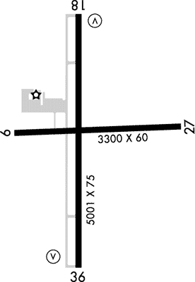
Runway 18/36
Dimensions:
5,001 × 75 ft
(1,524 × 23 m)
(1,524 × 23 m)
Weight Bearing Cap:
Single wheel: 30,000 lbs
Double wheel: 40,000 lbs
Double wheel: 40,000 lbs
Surface:
asphalt, no surface treatment, in good condition
Runway Edge Lights:
Medium
Comments:
n/a
| Designator: | 18 | 36 |
| Elevation: | 519.3 ft | 534.1 ft |
| Heading: | 183° magnetic 181° true | 362° magnetic 360° true |
| Gradient: | 0.3% up | 0.3% down |
| Traffic Pattern: | Left Pattern | Right Pattern |
| Markings: | non-precision, in Fair condition | non-precision, in Fair condition |
| Approach Lighting: |
|
|
| Displaced Threshold: | n/a | n/a |
| ILS/LOC: | n/a | n/a |
| Obstructions: | Tree, 84 ft Left ft of center, 60 ft high, 1,960 ft from end, 29:1 clearance slope | Tree, 438 ft Left ft of center, 51 ft high, 1,683 ft from end, 29:1 clearance slope |
| Comments: | n/a | n/a |
Runway 09/27
Dimensions:
3,300 × 60 ft
(1,006 × 18 m)
(1,006 × 18 m)
Weight Bearing Cap:
Single wheel: 13,000 lbs
Surface:
asphalt, no surface treatment, in good condition
Runway Edge Lights:
Medium
Comments:
n/a
| Designator: | 09 | 27 |
| Elevation: | 521.9 ft | 519.9 ft |
| Heading: | 089° magnetic 087° true | 269° magnetic 267° true |
| Gradient: | 0.06% down | 0.06% up |
| Traffic Pattern: | Right Pattern | Left Pattern |
| Markings: | basic, in Fair condition | basic, in Fair condition |
| Approach Lighting: | n/a | n/a |
| Displaced Threshold: | n/a | n/a |
| ILS/LOC: | n/a | n/a |
| Obstructions: | Road, Both-Sides, 13 ft high, 470 ft from end, 20:1 clearance slope | n/a |
| Comments: | n/a | n/a |
TFRs
Location: ENL
Please verify all content below using the FAA TFR Search Site or with a flight briefer.
TFR count: 0
NOTAMs
Location: ENL
Please verify all content below using the FAA NOTAM Search Site or with a flight briefer.
NOTAM count: 3
| Number: | Start Date: (UTC) | End Date: (UTC) | Condition: |
|---|---|---|---|
| 07/003 | 07/17/2025 0511 | 08/31/2025 0542 | OBST TOWER LGT (ASN 2023-WTE-5844-OE) 382353N0891408W (9.8NM SW ENL) 802FT (267FT AGL) U/S |
| 02/002 | 02/11/2025 1856 | 01/15/2026 2359 | OBST TOWER LGT (ASR 1028168) 382407.00N0890809.00W (7.1NM SSW ENL) 1033.5FT (498.7FT AGL) U/S |
| 07/002 | 07/16/2025 1529 | RWY 18 RWY END ID LGT U/S | |
Additional Remarks
For Cd If Una to CTC on FSS Freq, CTC Kansas City ARTCC at 913-254-8508.
Source:
FAA
Federal Aviation Administration
Noise Abatement
Instrument Procedures
Data Cycle:
Operations & More Information
Lat/Long:
- 38.51508, -89.09114
- 38° 30′ 54.3″ N, 89° 5′ 28.1″ W
- 38° 30.905′ N, 89° 5.468′ W
ARTCC:
Kansas City (ZKC)
App/Depart Control Facility:
Unknown
Chart:
NACO: St Louis Sectional
FSS:
Saint Louis (STL)
1-800-WX-BRIEF
1-800-WX-BRIEF
Wind Indicator:
Lighted
Mag Var:
02W (2010)
NOTAM Facility:
Seg Circle:
Yes
Beacon:
Present
Lighting:
Actvt MIRL Ry 09/27, Ry 18/36 & REIL Ry 18/36 - CTAF.
FAA
Pattern Altitude:
No data provided. Assume 1000 AGL.
Special Operations:
Communications Card
| Type: | Frequency / Phone: | Sector / Comments: | Call Sign: |
|---|---|---|---|
| AWOS-3PT | 121.125T (618) 533-4417 | ||
| CTAF | 122.8 | ||
| UNICOM | 122.8 |
Navaids
Services
Fuel:
100LL Low-Lead, Jet A
AM
Engine Repair:
None
Airframe Repair:
None
Bottled Oxygen:
None
Bulk Oxygen:
None
Customs:
None
Transportation:
Public Transportation
AM
Activities:
Intensive Flight Training
AM
Camping On Field:
None Reported
Aircraft & Activity
Webcams
METARs
TAFs
Contact Addresses
Airport Manager
Derek Sherman
Centralia, IL 62801
(618) 533-7622 (Office)
Owner
City of Centralia
Centralia, IL 62801
(618) 533-7622 (Office)
Remarks:
Cell # 618-918-8483
FAA
Email Address: Dsherman@Cityofcentralia.Org (All Lower Case)
FAA