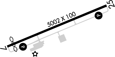
FAA Information Effective: Jun 12, 2025
All information is provided from the FAA unless otherwise noted.
(KFGX) Fleming-Mason Airport
1 rating | 1 review
Flemingsburg, KY
(606) 742-2411
Overview
Attendance:
Attended
Year-round,Mon-Fri/0800-1700
FAA
Year-round,Sat/1000-1600
FAA
Year-round,Sun/1100-1600
FAA
Runways:
07/25
Runway length: 5,002 ft (1,525 m)
Elevation:
913 ft (Surveyed)
Tower:
No
Airspace:
Unknown
Fees:
Ramp, Tie Down, Other
Click FBO link(s) below for details:
Click FBO link(s) below for details:
FBO Fee Details:
Fleming-Mason Aviation (FBO)Timezone:
EDT (UTC-04:00)
Sunrise-Sunset:
6:11 am - 9:02 pm
Evening-Morning Civil Twilight:
9:34 pm
(Today)
(Today)
-
5:39 am
(Tomorrow)
(Tomorrow)
Minimum Fuel Prices:
$4.99
100LL (self)
$5.20
Jet-A-Premix/Prist (full)
$4.75
Jet-A-Premix/Prist (self)
Runway
Satellite
Sectional
FBOs
Submit New FBO
Fleming-Mason Aviation (FBO)
No ratings | Be the first to review this business
Services Offered:
Flight Training
$4.99 | 100LL | self
$5.20 | Jet-A-Premix/Prist | full
$4.75 | Jet-A-Premix/Prist | self
Location:
On field: S
Phone:
(606) 742-2411
Freq. Monitored:
UNICOM: 123
Fees:
Ramp, Tie Down, Other
Flight Training
Submit New Flight School
Fleming-Mason Aviation (FBO)
No ratings | Be the first to review this business
Services Offered:
Flight Training
$4.99 | 100LL | self
$5.20 | Jet-A-Premix/Prist | full
$4.75 | Jet-A-Premix/Prist | self
Location:
On field: S
Phone:
(606) 742-2411
Freq. Monitored:
UNICOM: 123
Fees:
Ramp, Tie Down, Other
Other businesses
Submit New Business
AOPA Travel Discounts 
FlightBridge is the ultimate all-in-one travel booking platform built for the general aviation community. AOPA Members receive free access to FlightBridge with AOPA discounted rates automatically applied. Members save an average of 30% on hotel bookings! Learn more about FlightBridge HERE.
Local Food/Lodging/Activities
Local Attractions
Local Activities
Restaurants
Hotels and Lodging
Travel Discounts
Flying Clubs
Submit New Flying Club
Runway 07/25
Dimensions:
5,002 × 100 ft
(1,525 × 30 m)
(1,525 × 30 m)
Weight Bearing Cap:
Single wheel: 59,000 lbs
Double wheel: 79,000 lbs
Double wheel: 79,000 lbs
Surface:
asphalt, no surface treatment, in good condition
Runway Edge Lights:
Medium
Comments:
n/a
| Designator: | 07 | 25 |
| Elevation: | 905 ft | 910.7 ft |
| Heading: | 072° magnetic 067° true | 252° magnetic 247° true |
| Gradient: | 0.11% up | 0.11% down |
| Traffic Pattern: | Left Pattern | Left Pattern |
| Markings: | non-precision, in Poor condition | non-precision, in Poor condition |
| Approach Lighting: |
|
|
| Displaced Threshold: | n/a | n/a |
| ILS/LOC: | n/a | Localizer |
| Obstructions: | Tree, 197 ft Left ft of center, 19 ft high, 588 ft from end, 20:1 clearance slope | Tree, 153 ft Left ft of center, 20 ft high, 299 ft from end, 4:1 clearance slope |
| Comments: | Markings Faded. FAA | Markings Faded. FAA |
TFRs
Location: FGX
Please verify all content below using the FAA TFR Search Site or with a flight briefer.
TFR count: 0
NOTAMs
Location: FGX
Please verify all content below using the FAA NOTAM Search Site or with a flight briefer.
NOTAM count: 5
| Number: | Start Date: (UTC) | End Date: (UTC) | Condition: |
|---|---|---|---|
| 05/212 | 05/13/2025 0926 | 06/27/2025 0924 | OBST TOWER LGT (ASN 2013-ASO-9825-OE) 384153N0834738W (9.7NM NNW FGX) 801FT (295FT AGL) U/S |
| 06/256 | 06/15/2025 2130 | 06/30/2025 0400 | OBST TOWER LGT (ASR 1206373) 383435.70N0832623.40W (14.4NM E FGX) 1445.2FT (392.1FT AGL) U/S |
| 06/024 | 06/02/2025 1708 | 06/30/2025 2359 | RWY 07 PAPI U/S |
| 05/540 | 05/24/2025 1113 | 07/14/2025 2359 | OBST TOWER LGT (ASR 1044806) 382533.00N0834502.00W (7.0NM S FGX) 1190.9FT (268.0FT AGL) U/S |
| 05/211 | 05/13/2025 0926 | 06/27/2025 0922 | OBST TOWER LGT (ASR UNKNOWN) 384217.92N0834721.47W (10NM NNW FGX) 918FT (149FT AGL) U/S |
Additional Remarks
For Clearance Delivery Contact Indianapolis ARTCC at 317-247-2411.
Source:
FAA
Federal Aviation Administration
Noise Abatement
Instrument Procedures
Data Cycle:
Operations & More Information
Lat/Long:
- 38.54161, -83.74402
- 38° 32′ 29.8″ N, 83° 44′ 38.5″ W
- 38° 32.496′ N, 83° 44.641′ W
ARTCC:
Indianapolis (ZID)
App/Depart Control Facility:
Unknown
Chart:
NACO: Cincinnati Sectional
FSS:
Louisville (LOU)
1-800-WX-BRIEF
1-800-WX-BRIEF
Wind Indicator:
Yes
Mag Var:
05W (2000)
NOTAM Facility:
Seg Circle:
Yes
Beacon:
Present
Lighting:
Pilot Activated Lighting:
- low intensity: 3 clicks in 3 secs
- medium intensity: 5 clicks in 5 secs
- high intensity: 7 clicks in 7 secs
AM
Actvt REIL Rwy 07 & 25; PAPI Rwy 07 & 25; MIRL Rwy 07/25 - CTAF.
FAA
Pattern Altitude:
No data provided. Assume 1000 AGL.
Special Operations:
Communications Card
| Type: | Frequency / Phone: | Sector / Comments: | Call Sign: |
|---|---|---|---|
| AWOS-3 | 118.125T (606) 742-2008 | ||
| Clearance Delivery Phone | (317) 247-2411 | Indianapolis ARTCC | |
| CTAF | 123.0 | ||
| UNICOM | 123.0 |
Navaids
Services
Fuel:
100LL Low-Lead
AM
Engine Repair:
Minor
AM
Airframe Repair:
Minor
AM
Bottled Oxygen:
None
Bulk Oxygen:
None
Customs:
None
Transportation:
Courtesy Transportation
AM
Activities:
None Reported
Camping On Field:
None Reported
Aircraft & Activity
Webcams
METARs
TAFs
Contact Addresses
Airport Manager
Deron Mullikin
Maysville, KY 41056
(606) 742-2411 (Office)
Owner
Fleming-Mason Airport Board
Maysville, KY 41056
(606) 407-2966 (Office)
Remarks:
David Maher
FAA
Manager's Cell (606) 541-2957
FAA
Airport Reviews
Overall:
1 rating | 1 review
Runways and Taxiways:
Markings and Signage:
Ground Transportation:
Sort By:
- 10/25/20Karl T.Stopped for fuel & bathroom break. Nice new terminal building and helpful gent on hand. Crew car available tho we didn't need it.
