FAA Information Effective: Jul 10, 2025
All information is provided from the FAA unless otherwise noted.
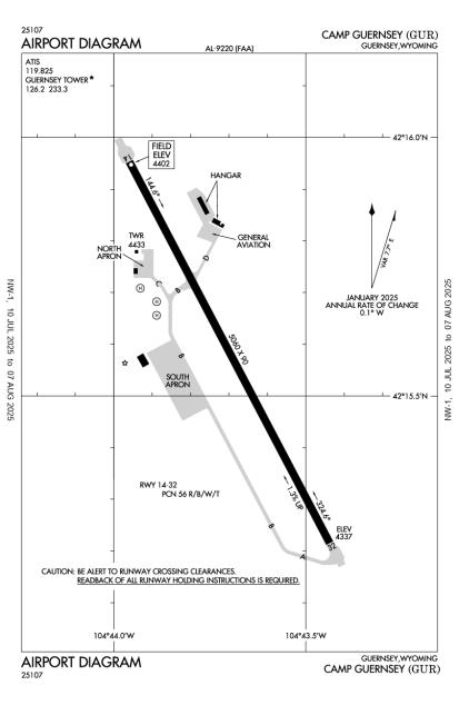
(KGUR) Camp Guernsey Airport
No ratings | 1 review
Guernsey, WY
(307) 836-7878
Overview
Attendance:
Attended
Apr-Sep/Mon-Fri/1400-0500Z++
FAA
Exc Hol.
FAA
Oct-Mar/Mon-Fri/1500-0600Z++
FAA
Elevation:
4,402 ft (Surveyed)
Tower:
Apch/Dep Ctl Svc Prvdd By Denver Artcc (Zdv) On Freqs 135.6/363.025 (Lusk Rcag).
FAA
Required Call To Guernsey Atct Prior To Entering R-7001/R-7002.
FAA
Tower Hrs: 1500-0600Z++ 01 JAN- 31 DEC MON-FRI; CLSD HOL.
FAA
Airspace:
CLASS D SVC 1400-0500Z++ 01 APR - 30 SEP, 1500-0600Z++ 01 OCT- 31 MAR, MON-FRI EXC HOL; OTHER TIMES CLASS E
FAA
Fees:
None
Timezone:
MDT (UTC-06:00)
Sunrise-Sunset:
5:47 am - 8:26 pm
Evening-Morning Civil Twilight:
8:58 pm
(Today)
(Today)
-
5:15 am
(Tomorrow)
(Tomorrow)
Runway
Satellite
Sectional
FBOs and Other Businesses
Submit New FBO
AOPA Travel Discounts 
FlightBridge is the ultimate all-in-one travel booking platform built for the general aviation community. AOPA Members receive free access to FlightBridge with AOPA discounted rates automatically applied. Members save an average of 30% on hotel bookings! Learn more about FlightBridge HERE.
Local Food/Lodging/Activities
Local Attractions
Local Activities
Restaurants
Hotels and Lodging
Travel Discounts
Flying Clubs
Submit New Flying Club
Runway 14/32
Dimensions:
5,060 × 90 ft
(1,542 × 27 m)
(1,542 × 27 m)
Weight Bearing Cap:
n/a
Surface:
asphalt, porous friction course, in fair condition
Runway Edge Lights:
Medium
Comments:
2S-175 Single Tandem Wheel Rating.
FAA
Rwy 14/32 10 Ft Asph Non-Weight Bearing Shoulders.
FAA
| Designator: | 14 | 32 |
| Elevation: | 4,401.8 ft | 4,337.3 ft |
| Heading: | 141° magnetic 152° true | 321° magnetic 332° true |
| Gradient: | 1.27% down | 1.27% up |
| Traffic Pattern: | Left Pattern | Right Pattern |
| Markings: | non-precision, in Good condition | non-precision, in Good condition |
| Approach Lighting: |
|
|
| Displaced Threshold: | n/a | n/a |
| ILS/LOC: | n/a | n/a |
| Obstructions: | n/a | n/a |
| Comments: | n/a | n/a |
Helipad H1
Dimensions:
80 × 80 ft
(24 × 24 m)
(24 × 24 m)
Weight Bearing Cap:
n/a
Surface:
concrete, no surface treatment, in good condition
Runway Edge Lights:
n/a
Comments:
n/a
| Designator: | H1 |
| Elevation: | 4,386 ft |
| Markings: | n/a |
| Obstructions: | n/a |
| Comments: | n/a |
Helipad H2
Dimensions:
80 × 80 ft
(24 × 24 m)
(24 × 24 m)
Weight Bearing Cap:
n/a
Surface:
concrete, no surface treatment, in good condition
Runway Edge Lights:
n/a
Comments:
n/a
| Designator: | H2 |
| Elevation: | 4,386 ft |
| Markings: | n/a |
| Obstructions: | n/a |
| Comments: | n/a |
Helipad H3
Dimensions:
80 × 80 ft
(24 × 24 m)
(24 × 24 m)
Weight Bearing Cap:
n/a
Surface:
concrete, no surface treatment, in good condition
Runway Edge Lights:
n/a
Comments:
n/a
| Designator: | H3 |
| Elevation: | 4,386 ft |
| Markings: | n/a |
| Obstructions: | n/a |
| Comments: | n/a |
TFRs
Location: GUR
Please verify all content below using the FAA TFR Search Site or with a flight briefer.
TFR count: 0
NOTAMs
Location: GUR
Please verify all content below using the FAA NOTAM Search Site or with a flight briefer.
NOTAM count: 4
| Number: | Start Date: (UTC) | End Date: (UTC) | Condition: |
|---|---|---|---|
| M0326/25 | 07/26/2025 0400 | 07/26/2025 0500 | TOWER NOT AVAILABLE |
| M0325/25 | 07/26/2025 0400 | 07/26/2025 0500 | BASE OPS NOT AVAILABLE |
| M0251/25 | 05/12/2025 2017 | 08/10/2025 1900 | AERODROME CONST AREA SOUTHWEST SIDE OF THE SOUTH APRON, UNLIT AND UNMARKED STRUCTURE |
| M0327/25 | 07/26/2025 0400 | 07/26/2025 0500 | AERODROME
MOBILE FUEL NOT AVAILABLE |
Additional Remarks
An/Fmq-23 Automated Obs Sys in Use: Briefing Svc Avbl Fm 25 Ows Dsn 228-6598/6599/6588 C520-228-6598.
Source:
FAA
Federal Aviation Administration
Arng: No Tran Mil Maint Avbl.
Source:
FAA
Federal Aviation Administration
Bldg 13 Ft Blw Sfc Elev Lctd 366 Ft Northwest Fr Rwy 32 Dep Zone Wi Clear Zone.
Source:
FAA
Federal Aviation Administration
Cfr Avbl Only on Apvd Prior Permission Required At Eta/Etd.
Source:
FAA
Federal Aviation Administration
City Has Lease Agreement with Military for Public Use.
Source:
FAA
Federal Aviation Administration
Fuel: Jet A Avbl by Ppr.
Source:
FAA
Federal Aviation Administration
Migratory Water Fowl, Birds, and Deer on and In vicinity of Rwy.
Source:
FAA
Federal Aviation Administration
Misc Small Arms Range Within 3Nm Radius of Gur, Sfc-4000 Ft AGL. R7001 A, B, C, D and R7002 A, B, C 6Nm Nw, Aircrews Must Obtain Apvl Fm Guernsey Twr Prior to Entering R7001 and R7002 When Active.
Source:
FAA
Federal Aviation Administration
Noise Abatement Areas Border W of Afld.
Source:
FAA
Federal Aviation Administration
Rstd: Air/Gnd Eqpt and Crash Rescue Avbl At Eta/Etd If Rqrd with Ppr.
Source:
FAA
Federal Aviation Administration
Rstd: All Trans Mil Acft Prior Permission Required Dsn 344-7884/2378; C307-836-7884/2378.
Source:
FAA
Federal Aviation Administration
Rstd: Extv Mil R/W and C-130/C17 F/W Opr Yr Round. Acft Weighing More Than 12,500 Lbs Must Use Conc Turn Arounds At Each Thld Int. All C130/C17 Acft Ppr.
Source:
FAA
Federal Aviation Administration
Rstd: North Apn Rstd to Rotor Wing/Fixed Wing Uh-60/C-12 or Smaller Acft.
Source:
FAA
Federal Aviation Administration
Rwy 14: 48 Ft Drop Off on Aer.
Source:
FAA
Federal Aviation Administration
Rwy 32: 12 Ft Drop Off on Aer.
Source:
FAA
Federal Aviation Administration
Service: Prior Permission Required Rqrd for Any Acft Requiring Services And/Or Parking on Mil Ramp. Crews Must Act As Their Own Svcg Supervisors.
Source:
FAA
Federal Aviation Administration
Service: Fuel 100LL-Not Avbl.
Source:
FAA
Federal Aviation Administration
Tfc Pat: F/W 5900 Ft R/W 5100 Ft, Left Tfc Ry 14, Rgt Tfc Ry 32.
Source:
FAA
Federal Aviation Administration
Twy D Edge Lgts Out of service Indef.
Source:
FAA
Federal Aviation Administration
Noise Abatement
Instrument Procedures
Data Cycle:
Operations & More Information
Lat/Long:
- 42.25974, -104.72831
- 42° 15′ 35.1″ N, 104° 43′ 41.9″ W
- 42° 15.584′ N, 104° 43.699′ W
ARTCC:
Denver (ZDV)
App/Depart Control Facility:
Unknown
Chart:
NACO: Cheyenne Sectional
FSS:
Casper (CPR)
1-800-WX-BRIEF
1-800-WX-BRIEF
Wind Indicator:
Lighted
Mag Var:
11E (1995)
NOTAM Facility:
Seg Circle:
Yes
Beacon:
Present
Lighting:
Actvt PAPI Rwy 14 & 32; MIRL Rwy 14/32 - CTAF.
FAA
Pattern Altitude:
No data provided. Assume 1000 AGL.
Special Operations:
Helicopter Ops
FAA
Communications Card
| Type: | Frequency / Phone: | Sector / Comments: | Call Sign: |
|---|---|---|---|
| ATIS | 119.825 | Guernsey | |
| CTAF | 126.2 | Guernsey | |
| OPS | 122.7 | COWBOY RDO, R-7001/R-7002 | Guernsey |
| Tower | 126.2 | Guernsey |
Navaids
Services
Fuel:
Jet A
AM
Engine Repair:
None
Airframe Repair:
None
Bottled Oxygen:
None
Bulk Oxygen:
None
Customs:
None
Transportation:
None Reported
AM
Activities:
None Reported
Camping On Field:
None Reported
Aircraft & Activity
Webcams
METARs
TAFs
Contact Addresses
Airport Manager
Maj. Jason Miller
Guernsey, WY 82214
(307) 836-7878 (Office)
Owner
State of Wyo Mil Dept
Cheyenne, WY 82009-3320
(307) 772-5235 (Office)
Airport Reviews
Overall:
No ratings | 1 review
Runways and Taxiways:No ratings
Markings and Signage:No ratings
Ground Transportation:No ratings
Sort By:
- 7/13/13JOSEPH W.Make sure you call ahead and notify them that you intend to land, and take on fuel! If not, you might be otherwise upset that you didn't.