FAA Information Effective: May 15, 2025
All information is provided from the FAA unless otherwise noted.
(KLBO) Floyd W Jones Lebanon Airport
No ratings | No reviews
Overview
Attendance:
Attended
Year-round, 7 Days a Week,0700-1800
FAA
Runways:
18/36
Runway length: 5,000 ft (1,524 m)
Elevation:
1,321 ft (Surveyed)
Tower:
No
Airspace:
Unknown
Fees:
Hangar, Landing, Ramp, Tie Down, Other
Click FBO link(s) below for details:
Click FBO link(s) below for details:
FBO Fee Details:
City of LebanonTimezone:
CDT (UTC-05:00)
Sunrise-Sunset:
5:52 am - 8:27 pm
Evening-Morning Civil Twilight:
8:58 pm
(Today)
(Today)
-
5:21 am
(Tomorrow)
(Tomorrow)
Minimum Fuel Prices:
$4.62
100LL (full)
$4.52
100LL (self)
$4.12
Jet-A-Premix/Prist (full)
Runway
Satellite
Sectional
FBOs
Submit New FBO
City of Lebanon
No ratings | Be the first to review this business
Services Offered:
$4.62 | 100LL | full
$4.52 | 100LL | self
$4.12 | Jet-A-Premix/Prist | full
Location:
On field: CTR
Phone:
(417) 532-7879
Freq. Monitored:
UNICOM: 122.8
Fees:
Hangar, Landing, Ramp, Tie Down, Other
Flight Training
Submit New Flight School
Other businesses
Submit New Business
AOPA Travel Discounts 
FlightBridge is the ultimate all-in-one travel booking platform built for the general aviation community. AOPA Members receive free access to FlightBridge with AOPA discounted rates automatically applied. Members save an average of 30% on hotel bookings! Learn more about FlightBridge HERE.
Local Food/Lodging/Activities
Local Attractions
Local Activities
Restaurants
Hotels and Lodging
Travel Discounts
Flying Clubs
Submit New Flying Club
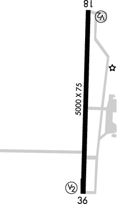
Runway 18/36
Dimensions:
5,000 × 75 ft
(1,524 × 23 m)
(1,524 × 23 m)
Weight Bearing Cap:
Single wheel: 33,000 lbs
Double wheel: 54,000 lbs
Double wheel: 54,000 lbs
Surface:
asphalt, no surface treatment, in excellent condition
Runway Edge Lights:
Medium
Comments:
n/a
| Designator: | 18 | 36 |
| Elevation: | 1,305.7 ft | 1,319.2 ft |
| Heading: | 179° magnetic 182° true | 0-1° magnetic 002° true |
| Gradient: | 0.27% up | 0.27% down |
| Traffic Pattern: | Left Pattern | Left Pattern |
| Markings: | non-precision, in Good condition | non-precision, in Good condition |
| Approach Lighting: |
|
|
| Displaced Threshold: | n/a | n/a |
| ILS/LOC: | n/a | SDF/DME |
| Obstructions: | Trees, Both-Sides, 26 ft high, 600 ft from end, 15:1 clearance slope | n/a |
| Comments: | n/a | n/a |
TFRs
Location: LBO
Please verify all content below using the FAA TFR Search Site or with a flight briefer.
TFR count: 0
NOTAMs
Location: LBO
Please verify all content below using the FAA NOTAM Search Site or with a flight briefer.
NOTAM count: 7
| Number: | Start Date: (UTC) | End Date: (UTC) | Condition: |
|---|---|---|---|
| 03/265 | 03/12/2025 1835 | 12/31/2025 2359 | OBST TOWER LGT (ASR 1065410) 374040.00N0924124.00W (2.5NM NW LBO) 1610.9FT (360.9FT AGL) U/S |
| 05/127 | 05/05/2025 1930 | 06/05/2025 2359 | OBST TOWER LGT (ASR 1007473) 373459.90N0924705.90W (7.4NM WSW LBO) 1650.9FT (277.9FT AGL) U/S |
| 04/437 | 04/23/2025 2124 | 07/23/2025 2359 | OBST TOWER LGT (ASR 1006843) 374227.70N0924245.90W (4.6NM NW LBO) 1696.2FT (434.1FT AGL) U/S |
| 4/1867 | 02/06/2024 1603 | IAP FLOYD W JONES LEBANON, LEBANON, MO.
RNAV (GPS) RWY 36, ORIG-C...
VGSI AND DESCENT ANGLES NOT COINCIDENT … | |
| 4/1560 | 02/05/2024 2029 | IAP FLOYD W JONES LEBANON, LEBANON, MO.
RNAV (GPS) RWY 18, ORIG-C...
DISREGARD NOTE: VGSI AND DESCENT ANGLE… | |
| 05/441 | 05/20/2025 0200 | 06/04/2025 0100 | OBST TOWER LGT (ASR 1280051) 374306.90N0923935.90W (4.2NM N LBO) 1489.8FT (259.8FT AGL) U/S |
| 05/596 | 05/26/2025 0131 | 09/23/2025 0131 | OBST TOWER LGT (ASR 1260107) 373730.50N0924117.30W (2.2NM SW LBO) 1554.1FT (258.9FT AGL) U/S |
Additional Remarks
Birds, Wildlife on & In vicinity of Arpt.
Source:
FAA
Federal Aviation Administration
For Clearance Delivery Contact Springfield Approach at 417-868-5620/5619.
Source:
FAA
Federal Aviation Administration
Sprayer Acft on and In vicinity of Airport During Spring and Summer Months.
Source:
FAA
Federal Aviation Administration
Noise Abatement
Instrument Procedures
Data Cycle:
Operations & More Information
Lat/Long:
- 37.64832, -92.65243
- 37° 38′ 54.0″ N, 92° 39′ 8.8″ W
- 37° 38.899′ N, 92° 39.146′ W
ARTCC:
Kansas City (ZKC)
App/Depart Control Facility:
SGF
Chart:
NACO: Kansas City Sectional
FSS:
Columbia (COU)
1-800-WX-BRIEF
1-800-WX-BRIEF
Wind Indicator:
Lighted
Mag Var:
03E (1990)
NOTAM Facility:
Seg Circle:
Yes
Beacon:
Present
Lighting:
Pilot Activated Lighting:
- medium intensity: 5 clicks in 5 secs
- high intensity: 7 clicks in 5 secs
AM
Actvt REIL Rwy 18 & 36; PAPI Rwy 36; MIRL Rwy 18/36 - CTAF.
FAA
Pattern Altitude:
No data provided. Assume 1000 AGL.
Special Operations:
Communications Card
| Type: | Frequency / Phone: | Sector / Comments: | Call Sign: |
|---|---|---|---|
| Approach/Departure | 121.1 | Springfield | |
| AWOS-3PT | 118.975T (417) 533-3419 | ||
| Clearance Delivery | 123.725 | Springfield | |
| Clearance Delivery Phone | (417) 868-5620 | Springfield Approach | |
| CTAF | 122.8 | ||
| UNICOM | 122.8 |
Navaids
Services
Fuel:
100LL Low-Lead, Jet A1 +Icing Inhibitor
AM
Engine Repair:
Minor
AM
Airframe Repair:
Minor
AM
Bottled Oxygen:
None
Bulk Oxygen:
None
Customs:
None
Transportation:
Courtesy Transportation
AM
Activities:
None Reported
Camping On Field:
None Reported
Aircraft & Activity
Webcams
METARs
TAFs
Contact Addresses
Airport Manager
Mike Wood
Lebanon, MO 65536
(417) 532-7879 (Office)
Owner
City of Lebanon
Lebanon, MO 65536
(417) 532-2156 (Office)