FAA Information Effective: Jul 10, 2025
All information is provided from the FAA unless otherwise noted.
(KONP) Newport Municipal Airport
1 rating | 1 review
Overview
Attendance:
Attended
Year-round, 7 Days a Week,0800-1700
FAA
Elevation:
160 ft (Surveyed)
Tower:
No
Airspace:
E
Fees:
Landing, Tie Down, Other
Click FBO link(s) below for details:
Click FBO link(s) below for details:
FBO Fee Details:
Newport Municipal AirportTimezone:
PDT (UTC-07:00)
Sunrise-Sunset:
5:53 am - 8:54 pm
Evening-Morning Civil Twilight:
9:28 pm
(Today)
(Today)
-
5:20 am
(Tomorrow)
(Tomorrow)
Minimum Fuel Prices:
$6.55
100LL (self)
$5.85
Jet-A (full)
$6.10
Jet-A-Premix/Prist (full)
Runway
Satellite
Sectional
FBOs
Submit New FBO
Newport Municipal Airport
No ratings | Be the first to review this business
Services Offered:
Car Rental
$6.55 | 100LL | self
$5.85 | Jet-A | full
$6.10 | Jet-A-Premix/Prist | full
Location:
On field: W
Phone:
(541) 867-7422
Freq. Monitored:
UNICOM: 122.8
Fees:
Landing, Tie Down, Other
Flight Training
Submit New Flight School
Other businesses
Submit New Business
AOPA Travel Discounts 
FlightBridge is the ultimate all-in-one travel booking platform built for the general aviation community. AOPA Members receive free access to FlightBridge with AOPA discounted rates automatically applied. Members save an average of 30% on hotel bookings! Learn more about FlightBridge HERE.
Local Food/Lodging/Activities
Local Attractions
Local Activities
Restaurants
Hotels and Lodging
Travel Discounts
(541) 867-3474
(541) 265-2424
(541) 265-9800
Lucky Thai Elephant
(541) 265-2959
(541) 265-8521
(541) 867-6002
Brewers on the Bay
(541) 867-3660
(541) 867-3670
(541) 265-8921
(541) 265-2979
(541) 994-9645
ONP
Oregon Coast Aquarium
NOAA Marine Operations
Hatfield Marine Science Center - OSU
Ocean Bleu Seafoods
Georgie's Grill
Lucky Thai Elephant
Embarcadero Resort
Fishtails Cafe'
Brewers on the Bay
House of Spirits
Yaquina Bay Lighthouse
Saffron Salmon
Mo's
Caravan Airport Transportation
Lincoln County Transit
Flying Clubs
Submit New Flying Club
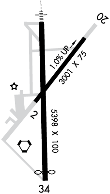
Runway 16/34
Dimensions:
5,398 × 100 ft
(1,645 × 30 m)
(1,645 × 30 m)
Weight Bearing Cap:
Single wheel: 75,000 lbs
Double wheel: 120,000 lbs
Double tandem: 170,000 lbs
Double wheel: 120,000 lbs
Double tandem: 170,000 lbs
Surface:
asphalt, no surface treatment, in good condition
Runway Edge Lights:
High
Comments:
n/a
| Designator: | 16 | 34 |
| Elevation: | 152.1 ft | 158.8 ft |
| Heading: | 162° magnetic 177° true | 342° magnetic 357° true |
| Gradient: | 0.12% up | 0.12% down |
| Traffic Pattern: | Right Pattern | Left Pattern |
| Markings: | precision, in Fair condition | precision, in Fair condition |
| Approach Lighting: |
|
|
| Displaced Threshold: | n/a | 300 ft |
| ILS/LOC: | ILS | n/a |
| Obstructions: | Trees, 450 ft Left ft of center, 24 ft high, 356 ft from end, 6:1 clearance slope | Trees, Both-Sides, 25 ft high, 467 ft from end, 10:1 clearance slope |
| Comments: | n/a | Rwy 34 PAPI Beyond 3Deg Left and 5Deg Right of Rcl Unusable FAA |
Runway 02/20
Dimensions:
3,001 × 75 ft
(915 × 23 m)
(915 × 23 m)
Weight Bearing Cap:
Single wheel: 33,000 lbs
Double wheel: 50,000 lbs
Double tandem: 84,000 lbs
Double wheel: 50,000 lbs
Double tandem: 84,000 lbs
Surface:
asphalt, no surface treatment, in good condition
Runway Edge Lights:
Medium
Comments:
n/a
| Designator: | 02 | 20 |
| Elevation: | 130 ft | 160.1 ft |
| Heading: | 022° magnetic 037° true | 202° magnetic 217° true |
| Gradient: | 1% up | 1% down |
| Traffic Pattern: | Left Pattern | Right Pattern |
| Markings: | basic, in Fair condition | basic, in Fair condition |
| Approach Lighting: | n/a | n/a |
| Displaced Threshold: | n/a | n/a |
| ILS/LOC: | n/a | n/a |
| Obstructions: | Terrain, 300 ft Right ft of center, 17 ft high, 875 ft from end, 39:1 clearance slope | Tree, 100 ft Right ft of center, 67 ft high, 1,085 ft from end, 13:1 clearance slope |
| Comments: | n/a | n/a |
TFRs
Location: ONP
Please verify all content below using the FAA TFR Search Site or with a flight briefer.
TFR count: 0
NOTAMs
Location: ONP
Please verify all content below using the FAA NOTAM Search Site or with a flight briefer.
NOTAM count: 4
| Number: | Start Date: (UTC) | End Date: (UTC) | Condition: |
|---|---|---|---|
| 07/002 | 07/02/2025 2102 | 07/11/2026 2359 | RWY 16 ALS NOT STD |
| 5/1976 | 07/21/2025 1802 | IAP NEWPORT MUNI, NEWPORT, OR.
VOR-A, AMDT 5A...
PROCEDURE NA FOR ARRIVALS ON ONP VORTAC RADIALS 260 CW TO 0… | |
| 3/7623 | 09/29/2023 1755 | IAP NEWPORT MUNI, NEWPORT, OR.
RNAV (GPS) RWY 16, AMDT 1A...
MISSED APPROACH: CHANGE MISSED APPROACH INSTRUC… | |
| 07/001 | 07/03/2025 0000 | 07/25/2025 1500 | AD AP SELF SERVE 100LL FUEL NOT AVBL DLY 0000-1500 |
Additional Remarks
Birds, Deer & Coyotes on and In vicinity of Arpt.
Source:
FAA
Federal Aviation Administration
For Cd If Una to CTC on FSS Freq, CTC Seattle ARTCC at 253-351-3694.
Source:
FAA
Federal Aviation Administration
Pilots Conducting Efvs Ops; be Aware Led Als in Use Rwy 16.
Source:
FAA
Federal Aviation Administration
Ppr for Acr Operations with More Than 30 Psgr Seats Call Airport Manager 541-867-7422.
Source:
FAA
Federal Aviation Administration
Noise Abatement
Instrument Procedures
Data Cycle:
Operations & More Information
Lat/Long:
- 44.58036, -124.05792
- 44° 34′ 49.3″ N, 124° 3′ 28.5″ W
- 44° 34.822′ N, 124° 3.475′ W
ARTCC:
Seattle (ZSE)
App/Depart Control Facility:
Unknown
Chart:
NACO: Seattle Sectional
FSS:
Mc Minnville (MMV)
1-800-WX-BRIEF
1-800-WX-BRIEF
Wind Indicator:
Lighted
Mag Var:
15E (2020)
NOTAM Facility:
Seg Circle:
Yes
Beacon:
Present
Lighting:
Pilot Activated Lighting:
- low intensity: 3 clicks in 5 secs
- medium intensity: 5 clicks in 5 secs
- high intensity: 7 clicks in 5 secs
AM
Actvt MALSR Rwy 16; MIRL Rys 02/20 & HIRL 16/34 and Papis Rwy 16 & Rwy 34 and REIL Ry 34 - CTAF.
FAA
Pattern Altitude:
No data provided. Assume 1000 AGL.
Special Operations:
Communications Card
| Type: | Frequency / Phone: | Sector / Comments: | Call Sign: |
|---|---|---|---|
| AWOS-3 | 133.9T (541) 867-4175 | ||
| CTAF | 122.8 | ||
| UNICOM | 122.8 |
Navaids
Services
Fuel:
100LL Low-Lead, Jet A
AM
Engine Repair:
None
Airframe Repair:
None
Bottled Oxygen:
None
Bulk Oxygen:
None
Customs:
None
Transportation:
None Reported
AM
Activities:
None Reported
Camping On Field:
None Reported
Aircraft & Activity
Webcams
METARs
TAFs
Contact Addresses
Airport Manager
Lance Vanderbeck
Newport, OR 97365
(541) 867-7422 (Office)
Owner
City of Newport
Newport, OR 97365
(541) 574-0603 (Office)