FAA Information Effective: Jul 10, 2025
All information is provided from the FAA unless otherwise noted.
(M13) Poplarville/Pearl River County Airport
No ratings | No reviews
Poplarville, MS
(601) 550-3059
Overview
Attendance:
Unattended
Unattended
FAA
Runways:
16/34
Runway length: 4,000 ft (1,219 m)
Elevation:
319 ft (Surveyed)
Tower:
No
Airspace:
Unknown
Fees:
Timezone:
CDT (UTC-05:00)
Sunrise-Sunset:
6:10 am - 8:00 pm
Evening-Morning Civil Twilight:
8:27 pm
(Today)
(Today)
-
5:44 am
(Tomorrow)
(Tomorrow)
Minimum Fuel Prices:
$5.15
100LL (self)
Runway
Satellite
Sectional
FBOs
Submit New FBO
City of Poplarville
No ratings | Be the first to review this business
Services Offered:
$5.15 | 100LL | self
Location:
On field: N
Phone:
(601) 550-3059
Freq. Monitored:
Fees:
Landing, Tie Down, Other
Flight Training
Submit New Flight School
Other businesses
Submit New Business
AOPA Travel Discounts 
FlightBridge is the ultimate all-in-one travel booking platform built for the general aviation community. AOPA Members receive free access to FlightBridge with AOPA discounted rates automatically applied. Members save an average of 30% on hotel bookings! Learn more about FlightBridge HERE.
Local Food/Lodging/Activities
Local Attractions
Local Activities
Restaurants
Hotels and Lodging
Travel Discounts
Flying Clubs
Submit New Flying Club
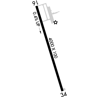
Runway 16/34
Dimensions:
4,000 × 100 ft
(1,219 × 30 m)
(1,219 × 30 m)
Weight Bearing Cap:
Single wheel: 25,000 lbs
Surface:
asphalt, no surface treatment, in fair condition
Runway Edge Lights:
Medium
Comments:
n/a
| Designator: | 16 | 34 |
| Elevation: | 302.6 ft | 318.9 ft |
| Heading: | 165° magnetic 163° true | 345° magnetic 343° true |
| Gradient: | 0.41% up | 0.41% down |
| Traffic Pattern: | Left Pattern | Left Pattern |
| Markings: | non-precision, in Fair condition | non-precision, in Fair condition |
| Approach Lighting: |
|
|
| Displaced Threshold: | n/a | n/a |
| ILS/LOC: | n/a | n/a |
| Obstructions: | Trees, Both-Sides, 55 ft high, 1,650 ft from end, 26:1 clearance slope | Trees, Both-Sides, 29 ft high, 800 ft from end, 20:1 clearance slope |
| Comments: | 335 Ft AGL Ant Twr on L Downwind Pat. FAA | Trrn Drops Off Abruptly 200 Ft Fm Thr. FAA |
TFRs
Location: M13
Please verify all content below using the FAA TFR Search Site or with a flight briefer.
TFR count: 0
NOTAMs
Location: M13
Please verify all content below using the FAA NOTAM Search Site or with a flight briefer.
NOTAM count: 7
| Number: | Start Date: (UTC) | End Date: (UTC) | Condition: |
|---|---|---|---|
| 07/348 | 07/12/2025 0005 | 07/25/2025 2359 | AD AP FUEL NOT AVBL |
| 06/809 | 06/21/2025 1230 | 07/26/2025 2030 | AIRSPACE UAS WI AN AREA DEFINED AS .5NM RADIUS OF 304735N0893023W (.3NM NNW M13) SFC-900FT AGL SAT 1230-2030 |
| 07/574 | 07/19/2025 1136 | 08/16/2025 0714 | OBST TOWER LGT (ASR 1295285) 304520.40N0892314.90W (6.3NM ESE M13) 408.8FT (261.8FT AGL) U/S |
| 06/370 | 06/10/2025 2215 | 09/08/2025 0400 | OBST TOWER LGT (ASR 1208553) 304401.70N0893234.40W (3.8NM SSW M13) 465.2FT (265.1FT AGL) U/S |
| 07/154 | 07/06/2025 1835 | 10/04/2025 0400 | OBST TOWER LGT (ASR 1039104) 303809.00N0892516.00W (9.9NM SSE M13) 694.9FT (499.0FT AGL) U/S |
| 07/440 | 07/14/2025 1116 | 10/12/2025 0400 | OBST TOWER LGT (ASR 1208209) 304755.60N0893949.80W (8.3NM W M13) 391.7FT (258.9FT AGL) U/S |
| 03/393 | 03/13/2025 1841 | RWY 16 PAPI U/S | |
Additional Remarks
For Clearance Delivery Contact Gulfport Approach at 228-265-6151, When Approach Clsd CTC Houston ARTCC at 281-230-5622.
Source:
FAA
Federal Aviation Administration
Ultralight Act on & In vicinity of Arpt.
Source:
FAA
Federal Aviation Administration
Noise Abatement
Instrument Procedures
Data Cycle:
Operations & More Information
Lat/Long:
- 30.78658, -89.50454
- 30° 47′ 11.7″ N, 89° 30′ 16.3″ W
- 30° 47.195′ N, 89° 30.272′ W
ARTCC:
Houston (ZHU)
App/Depart Control Facility:
GPT
Chart:
NACO: New Orleans Sectional
FSS:
Greenwood (GWO)
1-800-WX-BRIEF
1-800-WX-BRIEF
Wind Indicator:
Lighted
Mag Var:
02W (2020)
NOTAM Facility:
Seg Circle:
Yes
Beacon:
Present
Lighting:
Pilot Activated Lighting:
- high intensity: 5 clicks in 5 secs
AM
Mirl Rwy 16/34 Oper Dusk - 2100. Aft 2100 Actvt - CTAF. PAPI Rwy 16 & 34 Opr Consly.
FAA
Pattern Altitude:
No data provided. Assume 1000 AGL.
Special Operations:
Communications Card
| Type: | Frequency / Phone: | Sector / Comments: | Call Sign: |
|---|---|---|---|
| Approach/Departure | 124.6 | Gulfport | |
| Clearance Delivery Phone | (228) 265-6151 | Gulfport Approach | |
| Clearance Delivery Phone | (281) 230-5622 | When Approach Closed | Houston ARTCC |
| CTAF | 122.9 |
Navaids
Services
Fuel:
100LL Low-Lead
AM
Engine Repair:
Major
AM
Airframe Repair:
Major
AM
Bottled Oxygen:
None
Bulk Oxygen:
None
Customs:
None
Transportation:
None Reported
AM
Activities:
None Reported
Camping On Field:
None Reported
Aircraft & Activity
Webcams
METARs
TAFs
Contact Addresses
Airport Manager
Bradley Holliday
Poplarville, MS 39470
(601) 550-3059 (Office)
Owner
City of Poplarville & Pearl River
Poplarville, MS 39470
(601) 795-8161 (Office)