FAA Information Effective: Jun 12, 2025
All information is provided from the FAA unless otherwise noted.
(KMKA) Miller Municipal Airport
No ratings | No reviews
Miller, SD
(605) 853-2705
Overview
Attendance:
Attended
Irregular
FAA
Runways:
15/33
Runway length: 3,601 ft (1,098 m)
Elevation:
1,570 ft (Surveyed)
Tower:
No
Airspace:
Unknown
Fees:
None
Timezone:
CDT (UTC-05:00)
Sunrise-Sunset:
5:51 am - 9:23 pm
Evening-Morning Civil Twilight:
10:00 pm
(Today)
(Today)
-
5:14 am
(Tomorrow)
(Tomorrow)
Runway
Satellite
Sectional
FBOs and Other Businesses
Submit New FBO
AOPA Travel Discounts 
FlightBridge is the ultimate all-in-one travel booking platform built for the general aviation community. AOPA Members receive free access to FlightBridge with AOPA discounted rates automatically applied. Members save an average of 30% on hotel bookings! Learn more about FlightBridge HERE.
Local Food/Lodging/Activities
Local Attractions
Local Activities
Restaurants
Hotels and Lodging
Travel Discounts
Midway Drive In Theatermr Fri-Mon
Ranch Cafe
(605) 853-3441
Hi-Lite Lounge
(605) 853-9296
Dairy Queen
(605) 853-2399
MKA
Midway Drive In Theatermr Fri-Mon
Ranch Cafe
Hi-Lite Lounge
Dairy Queen
Flying Clubs
Submit New Flying Club
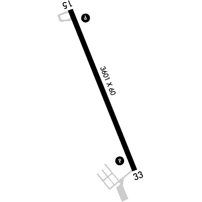
Runway 15/33
Dimensions:
3,601 × 60 ft
(1,098 × 18 m)
(1,098 × 18 m)
Weight Bearing Cap:
Single wheel: 125,000 lbs
Surface:
concrete, no surface treatment, in excellent condition
Runway Edge Lights:
Medium
Comments:
n/a
| Designator: | 15 | 33 |
| Elevation: | 1,560.8 ft | 1,569.6 ft |
| Heading: | 151° magnetic 158° true | 331° magnetic 338° true |
| Gradient: | 0.24% up | 0.24% down |
| Traffic Pattern: | Not provided. Assume LEFT traffic pattern | Not provided. Assume LEFT traffic pattern |
| Markings: | non-precision, in Good condition | non-precision, in Good condition |
| Approach Lighting: |
|
|
| Displaced Threshold: | n/a | n/a |
| ILS/LOC: | n/a | n/a |
| Obstructions: | n/a | Pole, 80 ft Right ft of center, 35 ft high, 1,370 ft from end, 33:1 clearance slope |
| Comments: | n/a | n/a |
TFRs
Location: MKA
Please verify all content below using the FAA TFR Search Site or with a flight briefer.
TFR count: 0
NOTAMs
Location: MKA
Please verify all content below using the FAA NOTAM Search Site or with a flight briefer.
NOTAM count: 4
| Number: | Start Date: (UTC) | End Date: (UTC) | Condition: |
|---|---|---|---|
| 03/069 | 03/13/2025 1153 | RWY 33 PAPI U/S | |
| 5/0918 | 06/09/2025 1820 | IAP MILLER MUNI, MILLER, SD.
RNAV (GPS) RWY 33, AMDT 1C...
MSA FROM RWY 33 25NM 3700.
THIS IS RNAV (GPS) RWY… | |
| 5/0917 | 06/09/2025 1820 | IAP MILLER MUNI, MILLER, SD.
RNAV (GPS) RWY 15, AMDT 1B...
MSA FROM RWY 15 25NM 3700.
CHANGE PBN REQUIREMENT… | |
| 05/108 | 05/30/2025 1836 | 06/30/2025 2359 | OBST TOWER LGT (ASR 1041174) 441843.00N0990336.00W (13.5NM SSW MKA) 2530.2FT (450.1FT AGL) U/S |
Additional Remarks
For Cd If Una Via GCO CTC Minneapolis ARTCC at 651-463-5588.
Source:
FAA
Federal Aviation Administration
Gco Avbl on Freq 121.725 (4 Clicks to Minneapolis Center and 6 Clicks to Flt Svcs)
Source:
FAA
Federal Aviation Administration
SuperAWOS/Automated UNICOM avbl (AUNICOM) 3 clicks for WX 4 clicks for radio check, CTAF
Source:
AM
Airport Manager
Noise Abatement
Instrument Procedures
Data Cycle:
Operations & More Information
Lat/Long:
- 44.52524, -98.95808
- 44° 31′ 30.9″ N, 98° 57′ 29.1″ W
- 44° 31.514′ N, 98° 57.485′ W
ARTCC:
Minneapolis (ZMP)
App/Depart Control Facility:
Unknown
Chart:
NACO: Twin Cities Sectional
FSS:
Huron (HON)
1-800-WX-BRIEF
1-800-WX-BRIEF
Wind Indicator:
Lighted
Mag Var:
07E (1995)
NOTAM Facility:
Seg Circle:
No
Beacon:
Not Present
Lighting:
Pilot Activated Lighting:
- medium intensity: 5 clicks in 10 secs
- high intensity: 7 clicks in 10 secs
AM
Actvt PAPI Rwys 15 & 33; MIRL Rwy 15/33 - 122.8.
FAA
Pattern Altitude:
Light Aircraft 2375 MSL
AM
Special Operations:
Communications Card
| Type: | Frequency / Phone: | Sector / Comments: | Call Sign: |
|---|---|---|---|
| CTAF | 122.9 |
Navaids
Services
Fuel:
100LL Low-Lead
AM
Engine Repair:
Minor
AM
Airframe Repair:
Minor
AM
Bottled Oxygen:
None
Bulk Oxygen:
None
Customs:
None
Transportation:
None Reported
AM
Activities:
None Reported
Camping On Field:
None Reported
Aircraft & Activity
Webcams
METARs
TAFs
Contact Addresses
Airport Manager
Terry Manning
Miller, SD 57362
(605) 853-2705 (Office)
Owner
City of Miller
Miller, SD 57362
(605) 853-2705 (Office)